

Meteorologist commenting on the interesting, the entertaining & the odd plus sometimes even weather.
- Tweets41.9K
- Following1.5K
- Followers17.5K
- Likes17.8K




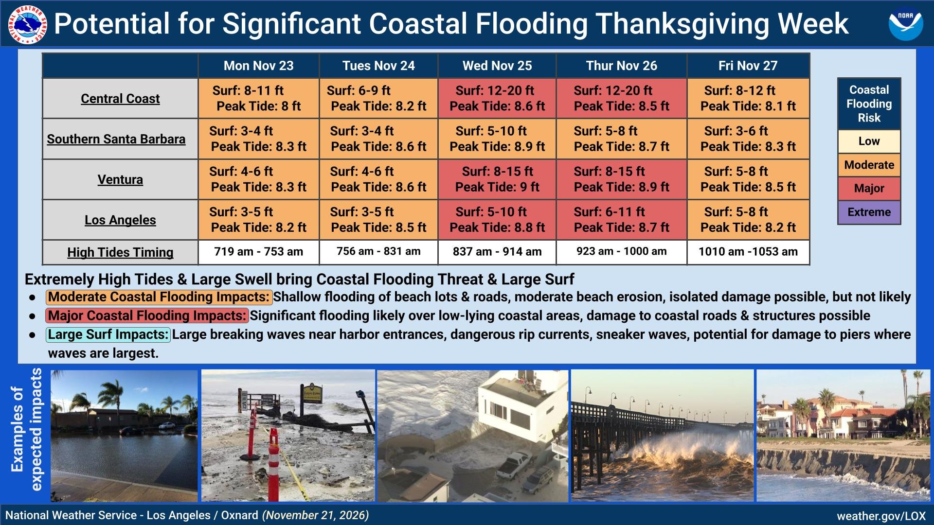
ALT Extremely high, record tides and large west swell brings a threat of moderate to major coastal flooding and high surf. Coastal flooding is likely throughout the week, especially for low lying, vulnerable areas. Tides and surf is forecast to peak Wednesday into Thursday, when the highest impacts are expected, with a greater potential for damage to coastal structures, roads, and piers. Now is the time to prepare. Follow guidance from local officials, use sand bags and barriers to protect property near the coasts, and make a plan in case of road closures. Boaters should follow guidance from harbor masters, and be aware of large breaking waves near harbor entrances.

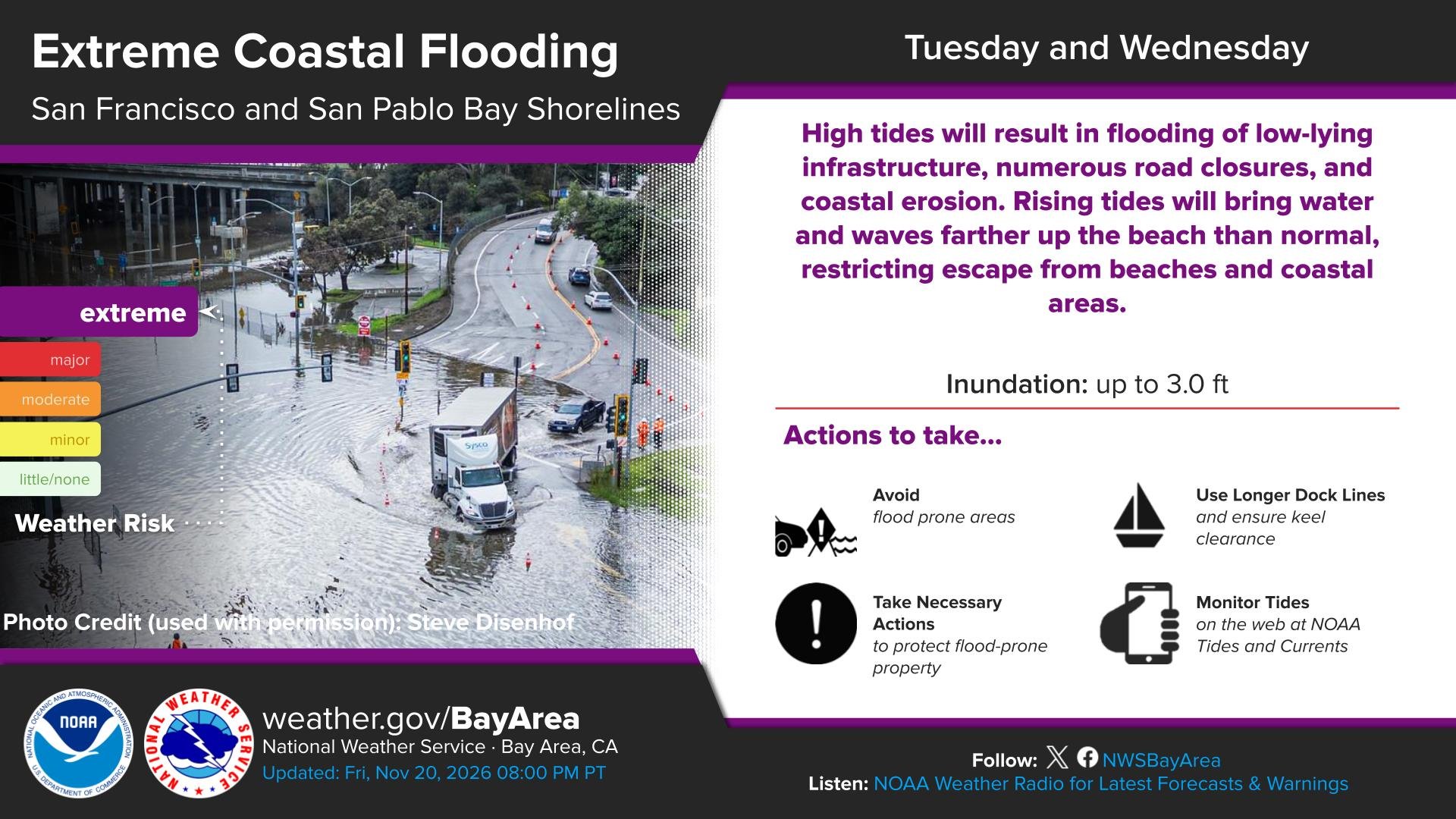
ALT Official social media graphic from NWS Bay Area describing the potential for "extreme" coastal flooding later this week around San Francisco Bay.

ALT Very high tides and high surf are forecast for next week, the week of November 23rd. If you live near the coast, now is the time to prepare. Heed advice from local officials, they know where problems are anticipated. Protect your property with sandbags or barriers, especially for vulnerable areas. If you plan to visit the coast, check for closures ahead of time. Go where there are lifeguards on duty and follow their guidance. Stay back from the water’s edge, and never turn your back to the ocean. Stay off rocks and jetties. If the area is wet from sea water, it is not safe from ocean waves.


ALT A Coastal Flood Advisory continues through 6 AM Monday for the San Pablo and San Francisco Bays, and through 4 PM Thursday for the Pacific Coast. Coastal flooding with up to 2.1 ft of inundation above ground level is possible in low-lying areas near shorelines and tidal waterways. High tides will result in flooding of low-lying infrastructure, numerous road closures, and coastal erosion. Rising tides will bring water and waves farther up the beach than normal, restricting escape from beaches and coastal areas. Take the necessary actions to protect flood-prone property. If travel is required, do not drive around barricades or through water of unknown depth.

ALT A Coastal Flood Warning comes into effect 6 AM Monday through 4 PM Thursday for the San Pablo and San Francisco Bays, while the Coastal Flood Advisory remains in effect through 4 PM Thursday for the Pacific Coast including Monterey Bay. Coastal flooding with up to 3.0 ft of inundation above ground level is possible in low-lying areas near shorelines and tidal waterways. High tides will result in flooding of low-lying infrastructure, numerous road closures, and coastal erosion. Rising tides will bring water and waves farther up the beach than normal, restricting escape from beaches and coastal areas. Take the necessary actions to protect flood-prone property. If travel is required, do not drive around barricades or through water of unknown depth.



ALT CONUS Precipitation Summary for 24-hours Ending 12 UTC, Thursday, 2026-11-19


ALT Day 1 Excessive Rainfall Outlook Wednesday, November 18, 2026 State: California Valid 2026-11-18 16:00Z - 2026-11-19 12:00Z Issued 2026-11-18 15:41Z | Weather Prediction Center Legend: Probability of excessive rainfall leading to flash flooding.* (*Within 25 miles of a point. May not represent localized flooding threat over burn scars.) High Risk, At least 70% (Magenta) Moderate Risk, At least 40% (Red) Slight Risk, At least 15% (Yellow) Marginal Risk, At least 5% (Green) Map Description: State map of California showing flash flood risk zones: Slight Risk (Yellow): Covers the central and southern coast and valleys from Santa Rosa, San Francisco, and San Jose south through Monterey and Santa Barbara. Marginal Risk (Green): Surrounds the Slight Risk area, extending north to Redding and Chico, inland through Sacramento, Stockton, Modesto, Fresno, and Bakersfield, and south toward Los Angeles.

ALT Day 1 Excessive Rainfall Outlook Wednesday, November 18, 2026 State: Florida Valid 2026-11-18 16:00Z - 2026-11-19 12:00Z Issued 2026-11-18 15:41Z | Weather Prediction Center Legend: Probability of excessive rainfall leading to flash flooding.* (*Within 25 miles of a point. May not represent localized flooding threat over burn scars.) High Risk, At least 70% (Magenta) Moderate Risk, At least 40% (Red) Slight Risk, At least 15% (Yellow) Marginal Risk, At least 5% (Green) Map Description: State map of Florida highlighting flash flood risk along the Atlantic coast and southern peninsula: Moderate Risk (Red): Narrow coastal strip from Daytona Beach south through Cape Canaveral and Melbourne to Ft. Pierce. Slight Risk (Yellow): Extends along the east coast from Jacksonville south through Palm Coast, Orlando, West Palm Beach, Ft. Lauderdale, and Miami. Marginal Risk (Green): Covers interior and southern areas including Gainesville, Okeechobee, and Marathon.


ALT A storm system is on its way to Southwest California, bringing moderate to heavy rain with totals of 1-3 inches across the region and 3-6 inches across the mountains and foothills. There is a 10-20% chance of thunderstorms, with the threat of locally heavy downpours and downburst winds. Additionally, snow levels will gradually drop to 5,000 ft through the storm. There is a high risk for significant roadway flooding, a high risk for strong creek flows, and moderate risk for rockslides and mudslides.

ALT Large Surf and Coastal Flooding are expected to continue through the week, peaking on Thursday. Highest for west-northwest facing beaches. Potential impacts include the following: Dangerous swimming & jetty conditions, shallow flooding of seawater over low lying beach walkways, parking lots, and roads, significant beach erosion likely. Locally higher impacts are expected along the Central Coast including impacts to roads, piers, and possibly structures. Remain far away from the water’s edge, do not swim in the ocean, stay off rock jetties, watch the big waves from a further distance than you think is safe, heed advice from local officials, continue to monitor latest forecasts.

ALT A graphic showing the total rainfall amounts expected through Tuesday, November 17th. The highest amounts expected along the northern CA and Oregon coasts, as well as the intermountain west.

ALT A graphic of the total snowfall expected across the intermountain west through Tuesday, November 17th. Highest snowfall amounts are expected in the higher elevations with max amounts of 8-10 inches in the northern Rockies.

ALT Map of predicted precipitation over the next 16 days from the ECMWF ensemble. In some wetter portions of Northern California, 6-10 inches of precipitation could fall during this period (with 4-5+ inches even in lower elevation portions of Bay Area/Central Valley).


ALT NOAA Weather Prediction Center map showing forecast precipitation across the western United States. The heaviest amounts are expected along coastal Washington, Oregon, and northern California, with widespread totals of 1–3 inches and localized amounts approaching 3 inches. Inland areas of the Pacific Northwest, Great Basin, and Southwest generally expect lighter precipitation, mostly under half an inch, with locally higher amounts in mountainous terrain.

ALT NOAA Weather Prediction Center map showing forecast snowfall across the western United States. Snow is primarily concentrated in higher elevations of the Cascades, Sierra Nevada, and Rocky Mountains. Forecast amounts generally range from a dusting to 2 inches, with locally heavier accumulations possible at higher elevations. Most lower-elevation areas are expected to receive little or no snow.


ALT A reasonably large atmospheric river made landfall today across areas of Northern California and into the Pacific Northwest. A second event is expected to bring more precipitation to the U.S. West Coast, along with the likelihood of snowfall into the Sierra Nevada's.


ALT Several periods of light to moderate rain are expected for SW California late Thursday night through next Wednesday as a series of disturbances move across the area. An initial wave is expected Thursday night through Friday night, followed by another wave Sunday through Monday night, and potentially a third impulse on Wednesday. Adjust outdoor plans in anticipation of wet and cooler conditions during this time.