

Rochester, MN
Joined May 2011
- Tweets18.1K
- Following2.5K
- Followers4.2K
- Likes5.7K

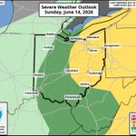


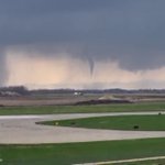



OHIO: Here’s the latest severe weather outlook for today. Expecting a line of showers and thunderstorms to develop along a cold front this afternoon and track eastward through the evening. A few storms could get strong enough to produce 40-60+ mph wind gusts. #OHwx

205
An ominous sight on the west side of Sioux Falls, SD where a Tornado Warning is in effect.
My sister sent me this video of what appears to be a wall cloud nearing the city.
Around 8:10 PM CDT, a tornado was confirmed on radar near Wall Lake. #SDwx

Severe Thunderstorm Warning issued for the counties of Franklin in Ohio until May 20 7:30AM EDT. Check 10TV.COM for severe weather updates.

1
131
How’s this for a view this morning?!
You’re looking at the Jackson Visitor Center located at Mount Rainier National Park. Definitely a lot of snow in the last couple of days!! #WAwx ❄️❄️

TORNADO SPOTTED! This is a tornado on the ground southwest of Rochester, MN moving towards the Rochester International Airport! #MNwx
📸: Minnesota DOT

607
#SafePlaceSelfie
Do you know where your safe place is at home, work, or school? Find it and take a selfie! @chris_tomer @MikeBehrensWX @JustinGehrtsWX @10TV

Check this out!! This is an image from LASCO Coronagraph, which is used to monitor solar activity, also capturing a comet heading towards the sun! That’s Comet C/2026 A1 (MAPS), which has been categorized as a Kreutz Sungrazer comet as it will pass incredibly close to the sun.

252

WHITEOUT: Nearly zero visibility in parts of western Wisconsin as very heavy snow is falling along I-94 near Osseo. No travel is advised as it may be pretty much impossible to get anywhere.
📸: Wisconsin DOT
📍: Osseo, WI

297
A rest area on I-65 near Roselawn, IN may have taken a hit from a tornado. Notice has the winds change direction through the video and intensity right before the camera loses power.
📸: Indiana DOT
A large crack in the ice has formed across Lake Erie today. Here's a satellite image taken around 2:30 PM EST showing the extent of the crack from near Cleveland across the lake to near Port Burwell in Canada. @10TV

WOW! A MAJOR X8.11 solar flare just occurred! This is one of the strongest solar flares of the current solar cycle (11 years).

So much snow!! This was a measurement in London, OH earlier this morning. Likely over a foot this afternoon!
📸: Melissa Fellure
📍: London, OH

2
343
It is not safe to be out on the roads today. This is a view of SR-315 where several cars have spun out and have gotten stuck in the snow.
📸: Ohio DOT

2
562

COLUMBUS! We set a new record high today with 65°! This breaks the previous record high of 62° set in 1949.
The cold front has moved through now and temperatures will drop through the 50s and 40s this afternoon and evening. @10TV

126
WHITEOUT: A blizzard is ongoing across Minnesota and Iowa as snow continues to fall. Winds are gusting over 40 mph in many locations leading to zero visibility. This is the scene along MN-60 near Windom, MN. #MNwx
📸: Minnesota DOT

