

Nonprofit organization tracking carbon in every tree and forest on the planet.
Pasadena, CA
Joined September 2022
- Tweets110
- Following466
- Followers797
- Likes73







CTrees retweeted

Sasaan Saatchi of Climate TRACE coalition member @CTrees_org recently wrote about the monumental difference this satellite will make for monitoring #carbon in tropical forests. ctrees.org/news/biomass-sate…

CTrees retweeted
NEW research published in @NatureClimate found that secondary forests with between 20-40 years of regrowth have up to 8x the carbon removal potential of new and mature forests per hectare. @CTrees_org ctrees.org/news/carbon-remov…


CTrees retweeted

🌿3-yr time-lapse of one of the Mother of Mothers trees of the Amazon rainforest 🌳🍃 likely one of the largest trees in the Amazon, with an astonishing crown diameter > 60 m and height > 50 m ! made with @NICFISatData 🛰️images. @CTrees_org #AmazonForest #TreeGiant #NatureWonder
CTrees retweeted
A new tool from Climate TRACE coalition members @CTrees_org allows you to track tropical forest degradation from roads, fires, and more tree cover loss using #satellite imagery and AI.
Check out REDD+AI:

Check out our new REDD+AI platform ctrees.org/reddai that shows tropical forest degradation—from logging, fire, and roads—and tree cover loss in evergreen forests with unprecedented detail. This is v1, so be kind :) v2 coming soon
@CTrees_org @RicardoDalagnol @NICFISatData

CTrees retweeted
Check out our new REDD+AI platform ctrees.org/reddai that shows tropical forest degradation—from logging, fire, and roads—and tree cover loss in evergreen forests with unprecedented detail. This is v1, so be kind :) v2 coming soon
@CTrees_org @RicardoDalagnol @NICFISatData
CTrees retweeted

📢🛰️🌳Forest degradation & tree cover loss in the tropics can now be seen w/ high resolution & attributions based on #ArtificialIntelligence and Planet @NICFISatData 5m satellite data
🪵🔥🛣️Available for viz at REDD+AI platform: ctrees.org/reddai
@CTrees_org @FabienWagner
CTrees retweeted
September 24th: Road to Belém: Raising Ambition for Jurisdictional Forest Finance panel discussion hosted by @CTrees_org. lu.ma/2aqhk9kd

CTrees retweeted
Today I gave an online talk at #GISFOREST event in Brazil on my research & @CTrees_org forest monitoring systems that track selective #logging & #roads
#CTrees technology & data help monitor forest management & illegal activities to enhance conservation & sustainable development

CTrees retweeted
Just discovered the most massive tree I've ever seen in the Amazon rainforest via satellite image—over 50 meters in crown diameter and more than 50 meters in height! 🛰🌳@CTrees_org @RicardoDalagnol

CTrees retweeted
Visited INPE this week and presented some updates on the research I lead at @CTrees_org. Top level discussions on forest degradation and applied AI for earth observation. Thanks @aragao_luiz @TREES_Research @dsrinpe for the invite ! :)

CTrees retweeted
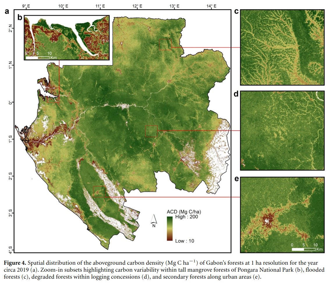
In 2020, 4 billion tons of live #carbon were stored in Gabon’s forests, according to new research from @CTrees_org.
Learn more about their findings from measuring the live carbon density of every hectare of forest in Gabon.
ctrees.org/news/gabon-carbon…
CTrees retweeted
📢🛰️New paper from Le Bien brings the most accurate #Carbon map of #Gabon to date based on #GEDI & #MachineLearning, verified using #ALS & National Plot Inventory, and shows its variability in the landscape and in forest management
doi.org/10.1088/1748-9326/ad…
@UCLAIoES @CTrees_org
CTrees retweeted
📢🌲Sharing our new paper led by Griffin Carter @gc_sci : "Detection of forest disturbance across California using deep-learning on PlanetScope imagery"
🔍Creek Fire in 2020 w/ CALFIRE map (red) and our 3x3 m detection (yellow)
📎 doi.org/10.3389/frsen.2024.1…
@UCLAIoES @CTrees_org

CTrees retweeted

We mapped a half billion individual farmland trees in India, and tracked their fate over a decade. Many large trees have disappeared. The paper in Nature Sus.: doi.org/10.1038/s41893-024-0…, Viewer: rs-cph.projects.earthengine.…. It's a new framework for temporal monitoring of single trees..

CTrees retweeted

🌿 Join our 13th EEBIOMASS #workshop on “High-resolution satellite imagery & #MachineLearning for #forest monitoring” on MAR 28, 14:30 - 16:30 CET.
👥 Meet our speakers: Martin Brandt, Eric Gorgens, Robson Lima, Ricardo Dalagnol
📢 Register here: survey.academiccloud.de/inde…

CTrees retweeted
📢🌳New paper led by @FabienWagner in RSE on tree's height mapping over California with #DeepLearning
I really like Fig 7 : it clearly shows how the model predicts height based on optical imagery very close to LiDAR even on STEEP terrain - crazy! 😮
doi.org/10.1016/j.rse.2024.1…


RELEASE: CTrees scientists led by @FabienWagner have mapped the height of all trees in California by applying a deep learning model to very high resolution aerial imagery.
The result is the most accurate map of the state's canopy height to date 🌐🌲ctrees.org/news/california-t…

ALT California canopy height map
CTrees retweeted
Our new published research on the Amazon’s 2023 Drought highlights our method for near real-time large scale mapping of water surfaces every 12 days using Deep Learning and Sentinel-1 SAR. mdpi.com/2716430
#amazonforest #drought @CTrees_org

CTrees retweeted
🛰️🌳🪵🔥Number of land use alerts in the Brazilian #Amazon in 2023 dropped to pre-2019 lvls. Still a lot of work to do for #ZeroDeforestation - letsgo!
📎 Data #LUCA @ bit.ly/ctrees-luca -@CTrees_org
PS: This feature to input your own GeoJSON ("new age shapefile") rocks.🚀

CTrees retweeted
🌍 Amazon's historic 2023 drought: Rio Negro River, one on the largest river of the Amazon, hits century-low by Oct/Nov😱Sentinel-1 SAR data & AI 🤖 reveal water surface decrease to 9,559.9 km², 68.1% of max. surface observed in 2022-23 🛰️🤖💧@CTrees_org arxiv.org/abs/2401.16393


CTrees retweeted

#GreenhouseGas emissions from tropical forest loss increased by 5% in 2022 from the year before, while temperate forests bolstered their carbon-absorbing capacity, according to @CTrees_org
Read the full news 👇
buff.ly/3v8hJxj
Via @MongabayOrg
