

Certified Broadcast & Consulting TV Meteorologist. I love weather & everything about it. I report on all things Meteorology, Astronomy, Geology & Geography.
Salt Lake City, Utah
Joined July 2014
- Tweets34.3K
- Following787
- Followers2K
- Likes32.5K


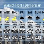


Nice, Then a Larger Storm This Weekend
Mild with a slight chance for night time showers the next two days. Partly cloudy until Friday, when there will be increasing clouds and rain showers developing. Heavier rain and thunderstorms this weekend, then drier and colder Monday. @weathercaster #utwx

Weak Hit and Miss Storms, but A Larger One is on The Horizon
We have a couple of weak fronts that will arrive Monday night and Tuesday night, so most of any measurable precipitation will not happen during the daytime. A larger system will bring widespread valley rain and mountain snow this weekend. @weathercaster #utwx

Great Views From Bell Canyon Reservoir
Fantastic colors today from Bell Canyon Reservoir, which is a beautiful lake that only requires a 1.3-1.5 mile hike, and is just south of Little Cottonwood Canyon. Bell Canyon is also called Bells Canyon. It is called both interchangeably depending on the source. @weathercaster #utwx
Video: Trent Sayer
Weak Storm, Then a Stronger Storm Late in the Week
A few lingering showers will dribble through the area tomorrow afternoon, while a weak storm brings a better chance for showers Monday night and early Tuesday. In between nice weather, until the end of the week, when a strong storm arrives. @weathercaster #utwx

Typical Fall Weekend, A Weak Storm Tuesday
There will be spotty showers this weekend, then a weak storm will push through the area on Tuesday. The remainder of the workweek will be seasonal, with partly cloudy skies and highs a bit on the cool side. Overnight lows dipping into the 30s. @weathercaster #utwx

Long Range Wet Weather to Continue
For much of the Southwest, including Southern Utah, and to some degree Northern Utah and the surrounding states, it will remain wetter than average for the end of October and the first week of November. Temperatures are forecast to be near average for this time of the year over much of the Western USA. @weathercaster #utwx


Rainfall Expected Through Friday at 6 PM
Here are the European and USA Computer model's forecast for rainfall up through 6 PM on Friday. As you can see, substantial precipitation is still expected across northern and parts of Eastern and Southern Utah. I'm still seeing .50" to .75", locally up to 1.25" along the Wasatch Front. The heaviest rainfall will be across far Northern Utah, because the rainfall will last longer on Friday afternoon into early evening. Some local flooding is possible, but northing like what has been happening around Hurricane and other parts of Southern Utah.


