

Chief Meteorologist for abc27 Harrisburg, PA. #WeAre alum, 5th generation farmer, droopy eye champion.
Joined December 2011
- Tweets12.3K
- Following469
- Followers6.2K
- Likes7K





For anyone heading out to a game this evening, we expect the line of storms will be out of the area before 7pm gametime:


Approaching narrow line of showers/storms producing a shelf cloud on the leading edge. Expect a 15-20 minute period of rain as this line pushes through.

Yes, it will get blustery and chilly for Saturday...HOWEVER, don't miss out on a breezy and very warm Friday before the front arrives into the evening.
**Could be our last time we warm into the 80s for the remainder of the year**

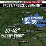
Frost Advisories just north of our viewing area. I still expect a few local areas to dip into the mid 30s overnight. Patchy frost particularly in the cooler valleys.


Late weekend outdoor plans will need to monitor the forecast. TD 9 is forecast to strengthen into the first Atlantic hurricane of the year. Our region is expected to see remnants of the storm Sunday into Monday. Our daily weather briefing at abc27.com.


A drier start to October with frost potential next week means farmer will be in full harvest mode to start the month.
abc27.com/weather/october-we…


Heads up Gratz Fair. Expect some heavy rain between 6:30-7pm. Rain should clear out shortly after 7pm:

Let's enjoy this week's weather as much as we can! Starting Sunday, several days of cool and damp weather develop into early next week.

Storms arriving 8pm to midnight. Similar to recent storms, expect frequent lightning and heavy downpours.

Quite the light show to our north! Can see the lightning from Harrisburg. These storms could reach parts of northern Dauphin county.

Sunshine returning as we move into this evening. This may trigger more storms across western PA during the evening, and could eventually reach our area likely after sunset.


A stray storm remains possible this evening, but better chances for storms will be Wednesday and Thursday as we remain in a favorable area for storm development.

One of those evenings where some places didn't get a drop, while others reporting 2-4" of rain. Heaviest rain occurred in southern Lebanon, northern Lancaster and central Dauphin counties:

This storm produced 3-4" of rain over Mount Gretna, southern Lebanon county. This storm also packing hail as it heads toward Ephrata, northeastern Lancaster county:


Thursday's storm will favor the evening hours (4-8pm), so any evening activities should monitor the radar tomorrow:
Can be tough to pin down the timing of these storm complexes in such a pattern, but models continue to suggest Tuesday night-Wednesday morning.