

Official X profile account for the Fort Worth Office of Emergency Management. This page is not monitored 24/7. If you have an emergency call 911.
Fort Worth, TX
Joined March 2009
- Tweets2.9K
- Following496
- Followers11.9K
- Likes2.3K






Same mission, different platform. Our online presence has been moved to help support our new department Emergency Management and Communications! The department enhances coordination and strengthens service initiatives to the community.
Follow us on our socials! @FortWorthEMC

July 1st, 2026. Good morning #FortWorth Today the City of Fort Worth will be conducting our monthly audible test of the Outdoor Warning Siren System at 1 PM CST. This is only a TEST. #NWSfortworth #txwx #dfww

6/3/2026 Today's Fort Worth Outdoor Warning System test is canceled due to forecasted overcast skies and potential storms in the area. The system is tested audibly on the first Wednesday of each month at 1 PM, with silent tests on the remaining Wednesdays. #FortWorth #NWS #txwx

Good afternoon,
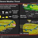
Scattered severe storms are expected this afternoon and evening and could bring the following:
- Large hail
- Damaging winds
- Locally heavy rain + isolated flash flooding.
OEM is monitoring the situation and we are ready to respond and support our community.

5/6/2026 Today's Fort Worth Outdoor Warning System test is canceled due to overcast skies. The system is tested audibly on the first Wednesday of each month at 1 PM, with silent tests on the following Wednesdays. #FortWorth #NWS #txwx

4
506
Check out this post on Nextdoor: nextdoor.com/p/LFtKZJqfnspk?…

687

3/4/2026
Today's Fort Worth Outdoor Warning System test is canceled due to overcast skies. The system is tested audibly on the first Wednesday of each month at 1 PM, with silent tests on the following Wednesdays. #FortWorth #NWS #txwx

Check out this post on Nextdoor: nextdoor.com/p/xJ9J_8P8Mp_M?…

1
528
1/23/2026
There have been minimal changes to the forecast during the past 24 hours other than minor refinements to timing and accumulation estimates.
A Winter Storm Warning is in effect for all of North Texas (beginning 6 PM this evening)


1/07/26
Good afternoon #FortWorth Today the City of Fort Worth will be conducting our monthly audible test of the Outdoor Warning Siren System at 1 PM CST. This is only a TEST. #NWSfortworth #txwx #dfww

12/3/25 Good morning #FortWorth Today the City of Fort Worth will be conducting our monthly audible test of the Outdoor Warning Siren System at 1 PM CST. This is only a TEST. #NWSfortworth #txwx #dfwwx
1
11
739
111/25 take extra time for your commute in the morning and use extreme caution! #fortworth

A Dense Fog Advisory is in effect for parts of Central and North Texas through 9 am. Visibility may drop to less than 1/4 mile at times through the night. Slow down and drive with extreme caution in the fog. #txwx #dfwwx

ALT A Dense Fog Advisory is in effect for parts of Central and North Texas through 9 am. Visibility may drop to less than 1/4 mile at times through the night. Slow down and drive with extreme caution in the fog.
Good Afternoon Fort Worth,
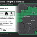
This afternoon into tomorrow, the Fort Worth area is under a “Marginal” Risk (1/5) for strong to severe thunderstorms and is also under a Flood Watch from 6 PM Sunday to 3 PM Monday.
Starting at 6 PM, spotty showers and thunderstorms will begin to enter the region, with the heaviest rain lagging behind it ahead of a frontal boundary. Similar to our last event, this system will bring two heavy waves of showers and thunderstorms. The first wave will arrive in Fort Worth around 1-2 AM on Monday, then around 5 AM the second and heaviest wave of storms will push through Fort Worth. This is when we will see our heaviest rainfall and strongest chance for severe weather, however the severe threat for North Texas is rather limited. After the second wave pushes through, showers and thunderstorms will continue until about 10 AM on Monday.
The main hazards with this system will be flash flooding, with a very low chance of hail and damaging winds, however most severe weather will occur south of the metro. Precipitation totals will most likely be between 1-3”, with the NWS calling for a 10% chance of precipitation up to 4”.
Stay tuned to NWS updates for the latest information on this developing system, and as always have multiple ways to receive warnings and stay weather aware!
#NWS #txwx #fwwx #dfwwx #KnowWhat2Do


⚠️Flash flooding will be the main concern Sunday evening into Monday morning. Please use caution when driving after dark - Turn Around, Don't Drown!


Good Afternoon Fort Worth,
Tomorrow Evening, Fort Worth and the greater DFW region will be under a “Marginal” Risk (1/5) for strong to severe thunderstorms with the main hazard concern being flooding.
Tomorrow afternoon, a strong upper-level disturbance will move in, producing torrential rains beginning early Sunday Evening and lasting well into Monday Morning. The main hazard with this system will be flash flooding, as the saturated ground from Thursday's event combined with heavy rainfall will produce high runoff and elevate the flooding risk. There is a low-end chance for severe weather including hail and a “non-zero” chance for a tornado or two, however lack of instability will most likely limit widespread severe weather.
Rain totals could reach 2-3 inches in some parts of North Texas, with the Fort Worth area most likely seeing between 1-2 inches. Current NWS forecasts project the highest precipitation to take place in the northern areas of DFW; however, these forecasts could shift so we will keep a close eye on those changes. Latest forecast model data shows rainfall arriving in Fort Worth between 6-8 PM on Sunday Evening, with consistent rainfall lasting until about 10 AM – 1 PM on Monday. Once the rain moves out on Monday, cooler drier conditions will take place, and the rest of the week will generally be dry and pleasant.
Stay tuned to NWS updates for the latest information on this developing system, and as always have multiple ways to receive warnings and stay weather aware!
#NWS #txwx #dfwwx #fwwx #KnowWhat2Do


11/20 3:20pm
⚠️Flash flooding is the main concern this evening. Please use caution when driving after dark - Turn Around, Don't Drown!

Good afternoon Fort Worth,
Tomorrow, our area will be under a “Marginal” Risk (1/5) for severe thunderstorms and heavy rainfall.
Beginning this evening, a two-wave storm system will begin to move through our area, with the first wave setting up west of Fort Worth around 12 AM Thursday. Our heaviest rain will occur between 2-4 AM, with on and off showers continuing to about 8 AM.
At about Noon tomorrow, the second wave of storms will set up west of Fort Worth and will begin to push through the area around 2 PM. Our heaviest rain will occur between 4-8 PM, with showers and thunderstorms lingering until about 10 PM.
Heavy rain and training of storms would cause urban and minor flooding, with rainfall totals up to 2-3” possible where training of storms occurs. The heaviest rain is expected on Thursday, particularly in the afternoon and evening hours, where the flash flood and flood threat is highest at this time. There is a low risk of severe weather, however some hail and flooding cannot be ruled out.
Stay tuned to NWS updates for the latest information on this developing system, and as always have multiple ways to receive warnings and stay weather aware! #NWS #txwx #fwwx #dfwwx #KnowWhat2Do

