




Pinned Tweet
HI-VIEW COMMENCES EXPLORATION PROGRAM IN TOODOGGONE MINING DISTRICT
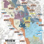
The 2026 program has planned for 50 line kilometres of induced polarization (IP) surveying, 50 square kilometres of geological mapping and prospecting, and approximately 4,000 soil samples covering more than 100 square kilometres. All soil samples will be analyzed using an ultratrace multielement package. Drill permits have been approved for the company's principal target areas of Lawyer’s East, Borealis, and the Golden Stranger with exploration activities focused around finalizing targets.
R. Nick Horsley, chief executive officer of Hi-View commented: "This exploration program will be focused on final target vectoring of porphyry targets focusing on the most advanced target areas. Once the data is collected from the priority targets the Company will look to advance towards a drill program.”
Target areas
Fieldwork is distributed across multiple target areas on the Property. Planned activities by area include:
· Lawyers East -- IP, soils, prospecting and mapping;
· Borealis -- IP, soils, prospecting and mapping;
· Black Pearl -- IP, soils, mapping and prospecting;
· Golden Stranger -- IP, soils and prospecting;
· Saunders -- IP, prospecting and mapping;
· Nub -- IP, soils and prospecting;
· Northern properties -- mapping and prospecting.
Additional target areas on the property include Harmon Peak, Ursus, Junker, Garnet and Oxide Summit.
Program details
IP surveying is planned over anomalies identified in the company's 2025 airborne magnetic data, in conjunction with areas that show coincident surface geochemical anomalies. Geological mapping will focus on detailing structure, alteration, veining and mineralization patterns in selected areas of interest, with the objective of vectoring toward porphyry- and epithermal-style mineralization. The program will validate legacy mapping and samples and examine new historically underexplored targets applying analytical techniques unused on the property (such as hyperspectral analysis, petrography and whole-rock geochemistry where necessary) to build the company's geological models and further delineate the company's targets.
Soil sampling will span prospective areas of the southern part of the property as well as Black Pearl, amongst the company's northern claims. Focus will be where rock exposure is more limited within the company's areas of interest and where legacy soil sample data were limited in results. The ultratrace multielement package is intended to detect low-level pathfinder elements, including tellurium and selenium, that are associated with porphyry-epithermal systems and are often missed at higher analytical detection limits.
Learn more about Hi-View Resources Inc.'s growing copper-gold land package in one of BC's most active exploration districts at: hiviewgold.com
$GXLD.CN | $GXLDF | $B630


HI-VIEW IP SURVEY IDENTIFIES MULTIPLE POTENTIAL PORPHYRY TARGETS AT THE BLACK PEARL, TOODOGGONE REGION, BRITISH COLUMBIA
Hi-View announces preliminary results from its 2026 exploration program at the Black Pearl target, part of its 100%-owned property in the Toodoggone District of north-central British Columbia (the “Property”).
Preliminary results from the induced polarization (“IP”) survey, supported by geological mapping and field observations, have identified compelling exploration targets consistent with the potential for a concealed porphyry system at depth. Geological observations suggest a possible vertical transition from higher-elevation, shallower low- to intermediate-sulphidation (“LS–IS”) epithermal alteration and mineralization at the Har showing to deeper-level pyrite-rich stringers that cut an intermediate to felsic dyke recently discovered near the Gord Davies West showing in the valley bottom.
This interpreted geological transition, together with coincident chargeability, resistivity, and magnetic anomalies identified during the 2026 exploration program, provides a strong basis for further investigation of a potentially buried porphyry system.
Exploration targeting in this area was further supported by a large, high-priority copper-silver-gold target identified in spring 2026 through Windfall Geotek Inc.’s artificial intelligence (“AI”)-driven machine learning system.
IP Survey Highlights
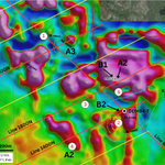
· The company completed 16 line-km of IP at Black Pearl. The survey tested an abrupt high magnetic anomaly flanking an E-W trending magnetic destruction anomaly, on the south side of the cliff face at Black Pearl.
· Target 1: Preliminary IP results outline a high chargeability anomaly (>30 mV/V) 1,000 m long (E-W) and 800 m wide (N-S). The anomaly begins at 200 to 300 m depth, extends to at least 400 m depth, and remains open at depth and towards the south. A narrow, north-northwest trending resistivity high anomaly coincides with the chargeability and magnetic anomalies (Figure 1 & 2).
· Target 2: A secondary chargeability high (>40 mV/V) and associated north-northeast trending resistivity high anomaly target is emerging to the east-northeast. The target extends beyond the Property boundary into TDG GOLD CORP. and continues back into Hi-View Property where BR 574 and McClair showings occur.
· Program Completed: 16 line-km of IP, 428 soil samples, and field mapping and rock sampling. Soil and rock assay results are pending.
R Nick Horsley, Chief Executive Officer of Hi-View, commented: “I believe the Toodoggone District will one day be recognized as one of the richest mineral belts in North America, and Black Pearl is emerging as one of its best porphyry targets. Our first 16 line-kilometres of IP have outlined a chargeability anomaly 1,000 metres long and 800 metres wide that remains open at depth and to the south. An anomaly of this size and strike has the potential to host a world-class discovery. It aligns with the magnetic and resistivity data, as well as surface geology that transitions from epithermal veins into breccia-hosted sulphides, the classic vectors we look for above a buried porphyry. Assays from 428 soil samples and our rock samples are pending and will help finalize target prioritization.”
Preliminary Mapping and Rock Sampling
At the Har showing, LS-IS epithermal-style calcite-barite-sulphide-bearing veins (Sample A; Figure 3) are predominantly shallowly south-dipping and subparallel to volcanic layering within porphyritic andesite of the Toodoggone Formation. Locally, steeply dipping to subvertical veins crosscut both the volcanic host rocks and intrusions of the Black Lake intrusive suite.
At lower elevations, the Gord Davies West showing is characterized by silicified breccia containing cubic galena and pyrite, with minor chalcopyrite. A few metres from the showing, a newly identified intermediate- to felsic-composition dyke is crosscut by sulphide-rich hydrothermal veins and exhibits mosaic brecciation (Sample B; Figure 3).
Sample A: A shallowly south-dipping barite-calcite ± sphalerite ± galena vein with pyrite-chalcopyrite in vein selvages. The vein cuts porphyritic andesite at higher elevations on the southern flank of the cliffs.
Sample B: K-feldspar-porphyritic intermediate to felsic dyke is strongly gossanous and silicified, with dark pyrite-rich alteration stringers locally producing a mosaic breccia. The dyke contains approximately 15% rounded, millimetre- to 0.5 cm-scale voids filled predominantly with barite and minor calcite. Barite appears to postdate the pyrite ± chalcopyrite stringers, locally infilling and crosscutting them. The pyrite ± chalcopyrite stringers define two principal orientations, E–W and N–S, and generally dip at moderate to steep angles.
View full release and learn more about Hi-View Resources Inc.'s growing copper-gold land package in one of BC's most active exploration districts at: hiviewgold.com
$GXLD.CN 🇨🇦 | $GXLDF 🇺🇸 | $B630 🇩🇪


Hi-View is pleased to announce that its Toodoggone land package, totalling >30,635 hectares, is now 100% owned. The Company has made all the final payments on all its optioned properties, with no further payments outstanding on any property within the package.
R. Nick Horsley, CEO of Hi-View, commented, "We are now in full control of over 30,000 hectares of highly prospective ground in the Toodoggone District. Once all of our assays and data are interpreted, I believe we will have some of the highest-quality porphyry targets in the camp. It has long been our belief that the Toodoggone region will eventually be recognized as one of the richest mineral belts in North America, and Hi-View will directly benefit from its aggressive acquisition strategy and grassroots exploration to date."
During the 2026 work program, Hi-View completed 63.78 line-km of induced polarization (IP) surveying, a 250 km² MobileMT survey, 3,251 soil samples, 337 rock samples and approximately 12 km² of geological mapping across ten target areas. Borealis and Lawyers received the largest share of work, with 41.54 line-km of IP and 2,346 soil samples combined. The program was designed to define priority targets and generate new targets for follow-up exploration. Samples have been submitted to ALS Global Laboratory in Vancouver, an ISO/IEC 17025 accredited facility. Assay results will be integrated with the IP and mapping data to rank targets and will be reported once received, reviewed and verified.
As previously announced on August 27, 2025 (see news release hereor available on SEDAR+), the Company has issued the final payment of $200,000 and 434,783 common shares to the vendor.
View full release and learn more about Hi-View Resources Inc.'s growing copper-gold land package in one of BC's most active exploration districts at: hiviewgold.com
$GXLD.CN 🇨🇦 | $HVWRF 🇺🇸 | $B630 🇩🇪

HI-VIEW ACQUIRES ADDITIONAL CONTIGUOUS MINERAL TENURES TO ITS JUNKERS PROPERTY IN THE TOODOGGONE MINING DISTRICT, BRITISH COLUMBIA
Hi-View announces that it has acquired additional contiguous claims to its Junker Property in the Toodoggone Gold & Copper District of northern British Columbia.
R Nick Horsley, Chief Executive Officer of Hi-View, commented: “Junkers is now seven claims and 3,473 hectares, and the additions bring the Junkers showing onto the property. This acquisition gives Hi-View another large-scale generative property in the Toodoggone.”
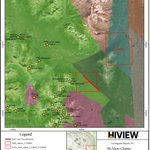
Junkers is seven claims and 3,473 ha in the northeastern part of the portfolio. The property dates from October 2025, when 1,372 ha of tenure applications were acquired and later registered as four claims. The newly added Junkers, Junker West, and Junker East claims to the north and northeast bring the Junkers occurrence onto the property, and the original four claims cover the southern and southwestern extensions of its stratigraphy and structures (Figure 1). The block has the greatest relief in the Company portfolio, rising from 1,300 m to 2,402 m in razor-backed ridges bounded by cliff faces, and is accessed by helicopter-only, about 36 km from Sturdee, 61 km from the Kemess airstrip, and 25 km beyond the road end at Lawyers.
The property is underlain by Lower to Middle Jurassic Hazelton Group marine sedimentary and volcanic rocks, the well-layered volcaniclastic unit that also hosts the Ursus skarn and the Harmon Peak veins, with a small Jurassic granodiorite body in the northeast of the block, at the corner of claim 1129846 and continuing north onto Junker East. The name comes from the Junkers Member of the Toodoggone Formation, the ash-flow tuff and rhyolite-dacite unit mapped at Oxide Summit.
The new claims comprise a 2021 helicopter-borne gradient magnetic survey over the core block that shows two strong anomalies that follow the East and West ridges, attributed in the survey report to the volume of magnetic rock exposed in them rather than to alteration or mineralization. A lineament analysis of the same data suggested a north-northwest-trending element crossing the West Ridge, coincident with the erosional notch that appears to feed the talus fan carrying a high-copper float sample at the occurrence and loosely associated with the anomalous 2004 samples in the West Valley. Elevated potassium and barium in the 2021 samples along that north-northwest trending lineament may indicate hydrothermal alteration. The occurrence itself consists of pyritic quartz veins and stringers carrying copper, lead, and silver with gold, and the 2021 float sample is chalcopyrite-rich.
Exploration began with a 1995 regional silt sample of 175 ppb Au from the creek draining the central basin. The 2004 Stealth Minerals prospecting program discovered the occurrence, a pyritic quartz vein subcrop returning 0.1% Cu and 1.08 g/t Au, with nearby quartz stringers at 0.2% Pb and 8.64 g/t Ag and float between 1 and 4.1 g/t Au. Rock samples from the same program in the project database ran 1,734 g/t Ag with 231 ppm Cu and 1,694 g/t Ag with 1.30 g/t Au and 0.88% Pb, with silts to 258 ppm Cu. The 2021 program added the airborne magnetics, reconnaissance mapping, a test line of contour soils and nine float samples from the talus fan, which ran 5.53%, 2.29%, 2.20% and 1.38% Cu with silver to 24 g/t, gold to 0.85 g/t and molybdenum to 104 ppm. A 2025 multispectral satellite analysis then picked out the occurrence along with 46 other sites for inspection.
During the 2026 exploration program the Company collected 4 grab samples from claim 1129845, 700 metres south of the Junkers mineral showing, where a 30m wide gossanous zone was identified including a prominent fault zone and silica and epidote veinlets with pyrite mineralization in the porphyritic andesite host rock. There has been no drilling or systematic soil sampling, and the southern claims have no sampling on record. Structural mapping and contour sampling at the exposed ends of the West Ridge, and reprocessing of the 2021 magnetics are the recommended next steps.
Terms of the Agreement
The Company has acquired 100% interest in the Property from an arm’s length vendor by issuing 125,000 common shares of the Company, making a $7,500 cash payment. The Property is encumbered by a two percent (2%) net smelter returns royalty which is payable to a previous owner of the Property, the payment of which will be assumed by Hi-View upon completion of the acquisition and will have the right to buy back one percent (1%) of the royalty for C$1,000,000.
View full release and learn more about Hi-View Resources Inc.'s growing copper-gold land package in one of BC's most active exploration districts at: hiviewgold.com
$GXLD.CN 🇨🇦 | $HVWRF 🇺🇸 | $B630 🇩🇪

HI-VIEW RESOURCES COMPLETES 2026 EXPLORATION FIELD PROGRAM IN THE TOODOGGONE MINING DISTRICT, BRITISH COLUMBIA
Hi-View has completed its 2026 exploration program at their Toodoggone projects in north-central British Columbia.
R Nick Horsley, Chief Executive Officer of Hi-View, commented: “Our team delivered an exceptional 2026 program, exceeding both scope and budget with a disciplined, multi-disciplinary approach that integrated geochemical sampling, advanced geophysics, and detailed geological mapping. The work has already generated a suite of compelling geochemical and geophysical anomalies across multiple target areas. While we await final assays and complete interpretation of the geophysical data, our preliminary results are highly encouraging. We are energized by what we’re seeing and look forward to sharing the full picture as we advance the most promising targets.
Nader Mostaghimi, Vice President of Exploration of Hi-View, commented: “Our 2026 exploration program has built meaningfully on the strong foundation established through previous work, while delivering significant advancements in our understanding of our projects. This summer’s mapping, sampling, and geophysical programs have provided greater definition of the geological controls on mineralization and allowed us to further refine and prioritize several key exploration targets. The progress made this year represents an important step forward in our exploration strategy, and we are encouraged by the potential these results present as we advance our robust and diverse group of projects toward the next phase of exploration.”
Program Highlights
🔶 63.78 line-km of induced polarization (IP) surveying across five target areas.
🔶 250 km² MobileMT Survey across the Golden Stranger, Lawyers North and East, and Borealis target areas.
🔶 3,251 soil samples collected.
🔶 337 rock samples collected.
🔶 Approximately 12 km² of geological mapping at 1:5,000 to 1:10,000 scale.
🔶 Work completed across ten target areas.
The program combined geochemical sampling, geophysical surveys and geological mapping methods. It was designed to define priority targets and generate new targets for follow-up exploration.
Samples have been submitted for analysis to ALS Global Labratory in Vancouver. This laboratory is accredited in accordance with the recognized International Standard ISO/IEC 17025. The Company expects to integrate gold assay and multielement results with the IP and mapping data to rank targets for follow-up work. Results will be reported once received, reviewed and verified.
View full release and learn more about Hi-View Resources Inc.'s growing copper-gold land package in one of BC's most active exploration districts at: hiviewgold.com
$GXLD.CN 🇨🇦 | $HVWRF 🇺🇸 | $B630 🇩🇪


HI-VIEW SUBMITS APPLICATION FOR SOFIA EAST CLAIM IN THE TOODOGGONE REGION
Hi-View announces the application, through staking, of the Sofia East Property in the Toodoggone Gold & Copper District of northern British Columbia. The property is contiguous to Amarc Resources Ltd.'s land package and adds the final open piece of Takla Group ground on the Pine trend to the Company's district-scale portfolio, expanding Hi-View's Toodoggone land position to 29,603 hectares.
R Nick Horsley, Chief Executive Officer of Hi-View, commented: “Staking Sofia East gives us the last open piece of Takla Group ground on the Pine trend, 10 km from Sofia and 12 km from Pine, where two major trends intersect. As we have advanced majority of our holdings we will continue to acquire low cost projects with the correct geology to continue grass roots exploration of the prolific Toodoggone District. We will review historical data and plan first-pass work.”
Sofia East is a single 1,693 ha claim (tenure 1139045) on the eastern flank of the Toodoggone camp about 10 km east of TDG Gold’s Sofia porphyry showing (MINFILE 094E 208), 12km northeast along the “Pine trend” from Amarc’s Pine porphyry deposit, and 1.8 km from the Nub claim. The claim is at relatively low altitude, mostly valley-floor to mid-slope ground of 969 to 1,772 m, gentle slopes, about 32 km from the Sturdee airstrip and 41 km from the Kemess airstrip, in the same helicopter-and-road setting as Nub.
The claim lies within the eastern Stikine terrane belt including Takla Group volcanics and along the contact of a north-trending regional-scale Finlay fault with west-flanking Early Jurassic granodiorite to granite intrusions towards the western portion of the claim boundary. The contacts at that scale however, are schematic and have not been refined over The Property ground. Regionally, northwest-trending normal faults and northeast cross-structures control intrusive emplacement and fluid pathways yet, a north-trending magnetic high anomaly (1st vertical derivative of magnetic field) within the Takla volcanics infers a northerly-trending control may play an important role in localization of fluids.
The neighbouring Sofia property has three mineralization styles that make the district position relevant. Low-sulphidation gold-silver veins along the 6 km Griz-Sickle-Quartz Lake trend returned up to 3.5 g/t Au and 33 g/t Ag over 11.6 m. High-sulphidation silica-alunite-illite zones at Alunite Ridge, BS Gold and Alexandra define a 5 km alteration corridor with soils to 0.9 g/t Au and 0.2% Cu. The Sofia showing itself is potassic-altered quartz monzonite with quartz-magnetite-chalcopyrite veinlets, where 2007 drilling by BCGold returned 0.22% Cu and 0.16 g/t Au over 10 m and the 2022 QuestEx program (eleven holes, 4,398 m) returned 100.5 m of 0.16 g/t Au and 0.14% Cu and 117.9 m of 0.26 g/t Au and 0.21% Cu, interpreted as peripheral porphyry mineralization in Takla basalts beside the intrusion. Elevated manganese, potassic alteration with secondary biotite and north-northeast vein orientations in that drilling are read as vectors toward a fertile porphyry centre that has not been found, interpreted to lie northeast of the 2022 drill area beneath the Toodoggone River valley.
The Property lies east of the drilled peripheral mineralization, on the projected extension of the Sofia stratigraphy and intrusive setting, in low altitude, covered valley ground of the kind that conceals porphyry centres. It adjoins the JOY project, which hosts the Pine, MEX and AuRORA porphyry deposits and is the northern extension of the Kemess district, and forms a land position with Nub between TDG’s and Amarc’s ground. The geophysical analogue is the northeast-trending magnetic high at Sofia, imaged by the 2015 deep IP as a near-vertical resistive core beneath the magnetic unit with an intensely chargeable cap and truncated on its northeast side by the Toodoggone River fault. The 2015 IP lines and the 2017 airborne magnetics end 6.5 to 7.5 km west of the claim, The first steps are to confirm the geology on the claim against the BCGS contact, compile the Cazador and QuestEx assessment reports over the area, extend the Nub IP and soil program across the claim, and map its intrusive contacts.
View full release and learn more about Hi-View Resources Inc.'s growing copper-gold land package in one of BC's most active exploration districts at: hiviewgold.com
$GXLD.CN 🇨🇦 | $HVWRF 🇺🇸 | $B630 🇩🇪

HI-VIEW RESOURCES TO ATTEND BEAVER CREEK’S PRECIOUS METALS SUMMIT
Hi-View announces that its Chief Executive Officer, R. Nick Horsley, will be in Beaver Creek, Colorado during the week of the 2026 Precious Metals Summit, which takes place September 22–25, 2026. The Precious Metals Summit is recognized as the world’s leading independent investment conference focused on explorers, developers, and emerging producers of gold, silver, and platinum group metals.
Mr. Horsley will be available in Beaver Creek for one-on-one meetings with institutional investors, analysts, and industry participants. These meetings will provide an opportunity to discuss the Company’s portfolio of gold, silver, and copper projects in British Columbia’s Toodoggone District and outline upcoming exploration plans.
R Nick Horsley, Chief Executive Officer of Hi-View, commented: “The Precious Metals Summit in Beaver Creek attracts many of the mining industry's leaders. Being here this week gives us the opportunity to meet with the financial community and industry peers to show how far we've advanced the Toodoggone portfolio this summer.”
Investors, analysts, and interested parties who wish to schedule a meeting with Mr. Horsley in Beaver Creek are invited to contact the Company at [email protected].
Learn more about Hi-View Resources Inc.'s growing copper-gold land package in one of BC's most active exploration districts at: hiviewgold.com
$GXLD.CN 🇨🇦 | $HVWRF 🇺🇸 | $B630 🇩🇪

HI-VIEW ACQUIRES THE JIM PROPERTY FEATURING GOSSANOUS ZONE IN THE TOODOGGONE REGION
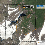
Hi-View announces that it has acquired the Jim Property in the Toodoggone Gold & Copper District of northern British Columbia. The Property is contiguous to Thesis Gold & Silver's land package and lies near Evergold Corp.'s Golden Lion project.
R Nick Horsley, Chief Executive Officer of Hi-View, commented: “The Jim Property acquisition further adds to our existing land position in the Toodoggone district. The property is surrounded by Thesis Gold & Silver's northern land package. With a gossanous zone visible at surface, we believe this could indicate hidden sulphide mineralization at depth, possibly associated with a copper porphyry system. We see this as a target worth following up on.”
The Property hosts the historic ‘JM’ showing, first documented in 1988 and sits adjacent to Thesis Gold & Silver's land package and near Evergold's Golden Lion project.
Malachite staining with associated chalcopyrite, was noted throughout the area, lining fracture planes and associated with quartz and calcite stringers within narrow shears. The combination of copper sulphides and oxides with gold and silver values, localized in fractures, shears, and quartz-calcite veining, suggests an epithermal hydrothermal system with stronger mineralization potentially concealed beneath the gossanous zone. Historically, the area has only been prospected so further mapping and analyses are warranted to follow up on. We see this as an opportunity to advance an epithermal target in a district that already hosts the Kemess, Aurora, Lawyers, and Baker deposits.
Terms of the Agreement:
The Company has acquired 100% interest in the Property from an arm's length vendor by issuing 100,000 common shares of the Company, making a $5,000 cash payment, and granting the vendor a 2% net smelter returns royalty (NSR) on the Property, of which the Company has the right to buy back 1% for $1,000,000.
Learn more about Hi-View Resources Inc.'s growing copper-gold land package in one of BC's most active exploration districts at: hiviewgold.com
$GXLD.CN 🇨🇦 | $HVWRF 🇺🇸 | $B630 🇩🇪

HI-VIEW RESOURCES CLOSES NON-BROKERED FLOW-THROUGH FINANCING
Hi-View is pleased to announce that, further to its news releases dated August 13, 2026 and September 4, 2026, the Company has closed its non-brokered private placement of charity flow-through units (the “Charity FT Units”). The Company issued 5,757,231 Charity FT Units at a price of $0.40 per Charity FT Unit for gross proceeds of $2,302,892 (the “Offering”).
Each Charity FT Unit consists of one common share in the capital of the Company (each, a “Common Share”) and one-half of one transferable common share purchase warrant (each whole warrant, a “Warrant”). Each Warrant entitles the holder thereof to purchase one additional non-flow-through common share (each, a “Warrant Share”, and together with the Common Shares and Warrants, the “Securities”) of the Company at $0.42 per Warrant Share for a period of 24 months from the date of issuance. Each Common Share and one-half Warrant will qualify as a “flow-through share” within the meaning of subsection 66(15) of the Income Tax Act (Canada).
The proceeds from the Offering will be used to incur eligible “Canadian exploration expenses” that qualify as “flow-through critical mineral mining expenditures” as both terms are defined in the Income Tax Act (Canada) and as “BC flow-through mining expenditures” as defined in the Income Tax Act (British Columbia) (the “Qualifying Expenditures”) related to the Company’s projects in British Columbia. The Company will renounce Qualifying Expenditures with an effective date of no later than December 31, 2026, in an amount of not less than the total amount of the gross proceeds raised from the issuance of the Charity FT Units, and incur such expenses by December 31, 2027. The flow-through critical mineral mining expenditures will be eligible for a federal 30% investment tax credit for any eligible individual investors and, for any individual investor who is resident or subject to tax in the Province of British Columbia, the Qualifying Expenditures will also be eligible for the 20% additional tax credit under the Income Tax Act(British Columbia).
In connection with the Offering the Company paid cash finder’s fees of $56,620.81 and issued 217,772 compensation warrants (“Compensation Warrants”) to a qualified arm’s length finder. Each Compensation Warrant entitles the holder thereof to purchase one common share in the capital of the Company (a “Compensation Warrant Share”) at $0.26 per Compensation Warrant Share for a period of 24 months from the date of issuance.
All securities issued are subject to a statutory hold period of four months and one day from the date of issuance.
The Securities have not been, nor will they be, registered under the United States Securities Act of 1933, as amended (the “U.S. Securities Act”), or any state securities laws, and may not be offered or sold within the United States, or to or for the account or benefit of any person in the United States or any U.S person, unless registered under the U.S. Securities Act and applicable state securities laws or unless an exemption from such registration is available. “United States” and “U.S. person” are as defined in Regulation S promulgated under the U.S. Securities Act. This press release shall not constitute an offer to sell or the solicitation of an offer to buy nor shall there be any sale of the securities in any state in which such offer, solicitation or sale would be unlawful.
Learn more about Hi-View Resources Inc.'s growing copper-gold land package in one of BC's most active exploration districts at: hiviewgold.com
$GXLD.CN 🇨🇦 | $HVWRF 🇺🇸 | $B630 🇩🇪
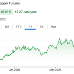
Copper futures at $6.83/lb, near record highs, on tight global supply 📈
BC's Toodoggone District sits in one of Canada's most active copper-gold belts. Hi-View is focused on advancing exploration across its Black Pearl, Lawyers East, Borealis and Golden Stranger projects ⛏️
Learn more about Hi-View Resources Inc.'s growing copper-gold land package in one of BC's most active exploration districts at: hiviewgold.com
$GXLD 🇨🇦 | $HVWRF 🇺🇸 | $B630 🇩🇪

With gold sitting above $4,600/oz USD, near its highest level in three months. Central banks bought a net 288.9 tonnes in Q2 2026, up 62% from a year earlier and the strongest second quarter on record, according to the World Gold Council. China alone has added to its reserves for 21 straight months.
🔗gold.org/goldhub/research/go…
Hi-View Resources is advancing its copper-gold portfolio in BC's Toodoggone District, one of Canada's most active porphyry and epithermal gold belts.
Learn more about Hi-View Resources Inc.'s growing copper-gold land package in one of BC's most active exploration districts at: hiviewgold.com
$GXLD.CN | $GXLDF | $B630

HI-VIEW IDENTIFIES FIVE HIGH-PRIORITY CHARGEABILITY ANOMALIES AT THE BOREALIS PORPHYRY TARGET IN THE TOODOGGONE
VANCOUVER, BRITISH COLUMBIA, AUGUST 6, 2026 – HI-VIEW RESOURCES INC. (“Hi-View” or the “Company”) (CSE: GXLD; OTC: GXLDF; FSE: B630) announces preliminary 2026 field results from the Borealis Project in the Toodoggone Mining District of north-central British Columbia. Hi-View has now completed 14 line-kilometres of induced polarization ("IP") survey over the historical Cas showing at the Borealis Project. The 2026 survey identified five chargeability anomalies, each representing a potential mineralized target for future drilling. The 2026 geological mapping and rock sampling over these areas have identified zoned alteration and localized copper mineralization suggesting a large-scale hydrothermal system. The Cas showing is located approximately 10 kilometres northwest from Centerra Gold's past-producing Kemess copper-gold mine. The Company will now be conducting three additional lines of IP survey to further define the targets. Rock and soil samples mentioned in this news release from the 2026 Borealis surface program have been submitted to ALS Geochemistry Ltd. (“ALS”) in North Vancouver, BC — an ISO/IEC 17025 accredited laboratory — for sample preparation and geochemical analysis. The samples were sealed in the field, stored securely, and transported by personnel of Apex Geoscience Ltd. of Edmonton, Alberta, to maintain chain of custody.
R. Nick Horsley, Chief Executive Officer of Hi-View, commented: “These new findings further confirm our hypothesis that Borealis contains a large hydrothermal system of the same style that created the porphyry complexes at Centerra’s Kemess and Amarc’s Joy projects. In the first few weeks of our field season, we have advanced from two historical IP targets to five distinct chargeability and resistivity anomalies. The program has reproduced historical signatures and provided new depth extensions, a previously unknown anomaly with copper mineralization at surface, and consistent porphyry-style alteration, giving us high confidence that the Borealis Project has potential for a significant discovery. With assays and hyperspectral analysis pending, new Mobile MT results imminent, and continued IP survey planned, these final datasets will enable further delineation of drill targets at Borealis.”
Highlights
· Five distinct strong-to-intense chargeability anomalies are preliminarily identified at Cas, up from two identified by Placer Dome’s historical work (1992), each representing a separate potential drill target.
· The 2026 IP survey reproduced the two main chargeability zones first outlined by the 1992 IP survey (Line 6000E).
· 2026 IP survey depth has extended sub-surface data from approximately 200 metres to 400 metres deep, defining a new high chargeability target at depth.
· Refined 2026 data show that the historical southern anomaly is in fact three separate chargeability anomalies, one of which remains open at depth (Line 1800N).
· A new, previously unidentified high-chargeability zone has been outlined southwest of Cas, coincident with copper mineralization mapped at surface (Line 1400N).
· A strong-to-intense chargeability anomaly on Line 2600N is associated with mapped crystal lithic tuff showing quartz-clay-pyrite (herein interpreted as "QSP") alteration and disseminated pyrite, also coincident with low resistivity.
Background
A 1984 drill campaign in the area included a diamond drill hole (DDH84-7; Figure 1) that reached a final depth of 43.2 m and did not intersect its intended target of a mineralized and altered N-trending fault west of the drill hole collar.
Historical IP surveying completed in 1992 produced two shallow, strong, high-chargeability zones at Cas, associated with pyritic clay alteration along the margin of a monzonitic intrusive body. The mapped intrusion produced a high-resistivity response typical of disseminated sulphide mineralization associated with copper porphyry systems.
Learn more about Hi-View Resources Inc.'s growing copper-gold land package in one of BC's most active exploration districts at: hiviewgold.com
$GXLD.CN | $GXLDF | $B630


Hi-View Resources Inc. CEO, Nick Horsley discusses sharpening drill targets with @miningcomau Danielle Doporto.
Join us and subscribe for updates at 👉 hiviewgold.com
Watch the full video 📹 youtu.be/MOG9R7G2kKU
$GXLD.CN 🇨🇦 $GXLDF 🇺🇸 $B630 🇩🇪

Copper and gold exploration doesn't happen in isolation. It happens where geology, infrastructure and jurisdiction all line up, and BC's Toodoggone District is proving to be exactly that kind of address.
Watch the latest CEO interview and see where the exploration story stands heading into the 2026 field season 👇🏼
youtube.com/watch?v=8UQ3lCQ5…
$GXLD.CN | $GXLDF | $B630
