

Borders, osint, & digital investigations | working @LHreports, sometimes more; past research @ForensicArchi
Joined August 2020
- Tweets1K
- Following1K
- Followers3.9K
- Likes3.2K




NEW: Since October 2023, the IDF Spokesperson's Unit has released dozens of 3D animations illustrating alleged Hamas, Hezbollah, and Iranian sites
The style is unmistakable: satellite zoom-ins, black & white wireframes, and red-textured houses - a new visual language of war
I’m in LA for @USCAnnenberg’s Open Source Journalism Conference the next couple days.
If anyone’s around and wants to catch up or talk open source journalism / or @LHreports work, give me a shout!
Really nice to be included in this @CJR piece on the future of visual investigations, alongside a great group of people from across the field.
I spoke a bit about how the online environment has changed as a space for open-source work and discussion.
cjr.org/feature/the-future-o…

I think we'll try and put out a more detailed methodology write up on the website in the next weeks!
Jack Sapoch retweeted

An FT visual investigation found systematic destruction across Israeli-occupied southern Lebanon, crippling systems essential to civilian life, from water and energy infrastructure to medical care. Raya Jalabi reports on the scale of the devastation. ft.trib.al/atpwoGT
This is just an overview of a specific corner of the larger effort, which pieces together the different effects of this damage. Find the full investigation below.
Appreciative to work on this w/ @rayajalabi @AditiHBhandari @samjoiner + @LHreports team
ft.com/content/25bc2df2-7ab8…

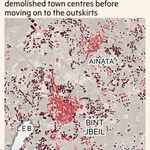
In some of the worst-hit villages, destruction started at the village centre and radiates outward over weeks
We cross-referenced these observations by conducting manual annotation of changes on s2 + high res imagery on building polygons in certain villages (see attached)


Most of the building damage we detected came after the April 16 ceasefire, meaning clearance of towns that were already under Israeli control.
Extending out across months, this was valuable as an indicator for research and inquiry.
For publication, we mapped dominant change patterns across a 250m hexagonal grid, with respect to whether dominant change was observed before/after the April ceasefire


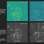
We split the timeline into two-week (cloud filtered) steps and compared each to the last (flagged w/ absolute decrease of 0.20 in saturation index), so we could see WHERE changed happened but also WHEN
Then we filtered the analysis to built-up areas and sieved out isolated flags

In false-color imagery, intact villages read as a mix of more saturated colors (vegetation, rooftops, mixed surfaces)
When demolished to rubble, that color collapses toward flat grey. We built a pipeline to measure that collapse, computed straight from the satellite bands
Sentinel-2 captures served as the base for temporal analysis, processed with a script in Google Earth Engine allowing us to track change across months and dozens of villages in single sweeps.
We focused on quantifying the visible shifts that explosive destruction produces
New collaborative investigation from @LHreports + @FT: we mapped how Israel has demolished village after village across southern Lebanon - much of it after a ceasefire.
A thread on the remote sensing damage analysis workflow we built to measure it 🧵
xitter.cf/FT/status/208741983520…

Analysis of satellite imagery, open-source data and verified footage shows that Israeli forces have systematically destroyed homes, roads, farmland and forests despite a ceasefire with Hizbollah. ft.trib.al/pw09Rva

Jack Sapoch retweeted

An excellent video on how eastern Libya helps arm Hemedti’s Rapid Support Forces, backed by the UAE.
Maybe other reporters have investigated the #Sudan war from eastern-Libyan soil; but I haven’t seen any. To me, this is the first, and it’s admirable work. Watch it on YouTube. @LHreports
youtube.com/watch?v=By8YVt4Z…

Jack Sapoch retweeted

New investigation shows how Libya has become a weapons trafficking and training hub for the RSF, who are committing horrific acts in Sudan, with the backing of the UAE.
Extremely important work by @JCSteers @LHreports @sudanwarmonitor and Evident Media.
Aydın Çıldır Airport is a major hub for these flights, which houses units from the Turkish Gendarmerie + Coast Guard. Both operate TB2s for maritime/border security (as does the Navy, from Çanakkale)
xitter.cf/AydinValiligi/status/2…
iha.com.tr/istanbul-haberler…


📍 Sahil Güvenlik Ege İHA Filo Komutanlığı
⚓ Ege Denizi’nde yürütülen deniz güvenliği faaliyetlerine havadan destek sağlayan Sahil Güvenlik İHA sistemleri, gözetleme ve denetim çalışmalarında etkin rol üstleniyor.
Sahil Güvenlik Komutanlığına bağlı unsurlarımızdan Sahil Güvenlik Ege İHA Filo Komutanlığını ziyaret eden Valimiz Sayın @DrOsmanVarol, komutanlık faaliyetleri hakkında yerinde bilgi aldı ve anı defterini imzaladı.
Sayın Valimiz, yürütülen çalışmaları yerinde inceleyerek personele görevlerinde başarılar diledi.


*The data is wrangled from adsb.lol via @bellingcat's Turnstone tool, then processed and visualized in Kepler.gl and finished in Davinci Resolve
A time-series viz of all publicly recorded* Bayraktar TB2 flights over western Turkey since late 2023
The tracks show how extensive/persistent these circular patterned surveillance flights are along the Aegean coast + Evros land border
Laiken's post raises an issue that appears along many fortified borders
On the EU/Belarus border, guards regularly post footage of moose + other large animals caught in razor wire along border fences - recent infrastructure that has disrupted historical patterns


