

Emmy-winning Meteorologist @ Sacramento Bee - @Univmiami 19 🙌 - Exploring/protecting 🌎 - Fan of deep dish and deep dives
Sacramento, CA
Joined February 2018
- Tweets4.2K
- Following1.8K
- Followers1.2K
- Likes27.1K






Sean Macaday retweeted

America’s newest national park is rock solid!
Chiricahua is officially our 64th national park. Welcome to the "Wonderland of Rocks."

ALT Lightning strikes beneath dark storm clouds over the rocky landscape of Chiricahua. Green vegetation surrounds clusters of towering rock formations, with a pink glow along the distant horizon.
Sean Macaday retweeted

The area burning today in San Clemente received over 1.60" of rain 5 days ago. So why is it burning?
Answer: Highly invasive black mustard, a CA non-native.
It dies each summer, leaving dry, highly flammable kindling that rainfall cannot revive.
Remove and plant natives.


#Rachel set from a landfall just south of the border, but I have a feeling the worst impacts are inland. Majove is pretty sparsely populated, but certianly some mountainous flooding risks even into Utah.

Pretty incredible, tropical storm watch up for San Diego. Decent chance a real tropical storm warning gets issued soon.
#Rachel is likely to make it ashore as a full fledged but transitioning tropical storm thanks the above average water temperature and its fast speed.
Coastal flooding will be a big issue. #cawx
An early October heat wave will hold steady across California and the western US into mid-October. Some blazing hot highs in the triple digits for SoCal, and much of the Central Valley will stick in the 90s without much of a breeze to help out.
#cawx
Sean Macaday retweeted
Posts have recently been circulating online claiming that it has "always been 100°F in October in Los Angeles."
These claims are misleading.
Historically, 100°F October days only occurred on 3-6 afternoons per decade. (1% - 2% of days)
Lately, they've gotten much more common.

Switching from TV to print has increased my respect for the care that goes into making a good headline. This is careless.

Climate scientists are warning that this year's El Niño could be one unlike we've ever seen before. Expected to be super-strong, the climate phenomenon is likely to fuel drought in some areas, flooding in others, and as many as 451,000 weather-related deaths. ktla.com/news/super-strong-e…

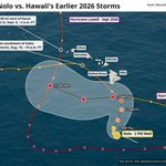
Newly formed Tropical Storm #Nolo will be the third hurricane to come awfully close to a landfall in Hawaii this season. And while a direct landfall is not likely, it will again bring intense rains. Hurricane watch up for the Big Island.

Just bonkers. #Polo has exploded into a Category 5 hurricane from a measly tropical storm just 24 hours ago. One of the strongest bouts of rapid intensificstion ever seen in the Eastern Pacific. Planetary coastally-trapped Kelvin waves have provided extra heat for the storms boost.
Matched against all recent storms, #Polo ties Milton from 2 years ago as the second most robust increase in wind speed, only falling short of Otis.

The hype surrounding #Marie is too high, largely thanks to a few single runs of deterministic models.
On the left, the average of Google's WeatherNext2 64 ensemble members. Not much rain for SoCal, but a few showers from monsoonal moisture in some scenarios.
On the right, a single run of the GFS. At this moment in weather modeling, the GFS is both more accessible to the public AND largely inferior to WN2.
Forecast for Marie will markedly improve today now that it has formed. #cawx

Sean Macaday retweeted
My hope was wrong this morning. Since the center of #MARIE has formed, I was hoping today's 12z suite would bring more clarity to the forecast track.
It has not.
It has just about as much discrepancy as ever. There is still very low forecast confidence with this thing.

A ~rough~ idea of California's snow season outlook as of now amid #ElNiño :
I took the CFSv2 precipitation and temperature anomaly outputs and applied adiabatic topology.
Warmer temps in the foothills could deter snowfall for many, but the signal remains for above-average snowfall at elevation, especially in the Sierra come December onward.
This does not take into account snowmelt or orographic effects. It is an early and rough estimate. #cawx


Early indications are that a wet winter is in store for California thanks to #ElNiño. Pretty much every climate model is pointing to above average precip come December & January.
This is only a single run of the CFSv2 pictured here, and real world dynamics would be much less smooth, but this provides a rough idea of what the state could reasonably expect. Actual rain events would have both higher and lower extremes.

