

New Zealand's weather service. Helping Kiwi's be ready, whatever the weather.
New Zealand
Joined December 2008
- Tweets54.1K
- Following1.4K
- Followers148K
- Likes11.8K




Here’s a look at the weather to start the week!
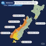
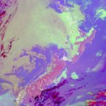
🌧️A fast-moving front makes its way up the country from early on Monday morning, bringing periods of rain to the whole country over Monday and Tuesday, heavy about the west coast of the South Island.
🍃Ahead of the front, gale northwesterly winds will affect much of the southern and eastern parts of the South Island from Monday morning, before arriving in Wellington Monday evening.
🚗 Travelling home after the long weekend? Stay alert, allow extra time for your journey, and drive to the conditions.
Keep up to date with the latest warnings and forecasts at metservice.com
🟠🟡Severe Weather Warnings & Watches🟡🟠
Heavy Rain and Strong Wind watches and warnings have been updated ahead of an upcoming active front.
Severe gale winds are expected in exposed areas over the eastern and southern South Island, and in Wellington.
Periods of heavy rain are expected over western areas of the South Island.
Keep up to date with the latest watches and warnings at metservice.com/warnings


Kia ora! ☀️
It’s shaping up to be another warm day across the east of the country, with persistent northwesterlies ahead of an approaching front.
🌡️ Highs of over 25°C are expected along the east coast of the South Island, as well as Hawke’s Bay. These warm temperatures are set to continue tomorrow before a front moves through, bringing a cooler west-southwesterly flow.
🥶 A noticeable change is on the way, with daytime highs in the east of the South Island potentially dropping by up to 12°C between Monday and Tuesday!
Make the most of the warmth while it lasts! 🌤️
🟠🟡Severe Weather Warnings & Watches🟡🟠
An active front, preceded by gale northwesterlies, moves over the South Island during Monday bringing very heavy rain to western areas and possible severe northwesterly gales for the southern and central South Island.
Watches and warnings are now in place for many parts of the South Island.
For further details, head to: metservice.com/warnings


☀️ Expect a warm weekend ahead, especially for those in the north and east of the country.
Clear, sunny skies combined with strengthening warm winds from the northwest 🌬️ will see some places reach for the 30s on Saturday. Both Hastings and Christchurch are currently forecast to reach a maximum temperature of 28°C.
Get the sunscreen out and drink plenty of water 💧 as you enjoy the weekend!
☀️ It's a repeat of yesterday! And the day before.... and the day before. 😴
Settled conditions continue across the country today as a ridge of high pressure continues to dominate. 🌤️ Some areas see a layer of cloud this morning, but that’ll start to burn off as the sun gets cooking. 🔥🌞

The sun is working hard today! ☀️
As the sun shines on the clouds from above, it works at evaporating them by lifting the air temperature, while the dew point stays constant🌡️
Here we can see low cloud and fog disappearing from the North Island, and cloud thinning over the sea ☁️
It'll be the same story for the rest of the week before a front arrives on Monday. Head to metservice.com for your forecast 👆
Ata mārie Aotearoa!
Here are the temperatures you woke up to this morning - then what to expect for today and tomorrow 🌞
It's a lot of sun with temperatures reaching 26°C in some places 🥵
How warm is it going to be at your place? Head to metservice.com/ to find out
Mōrena Aotearoa! 🌅
This is the satellite imagery for 6am 🛰️
In order to be able to see clouds using satellite imagery at night, a special night microphysics imagery is used. The light green cloud indicates lower level cloud, whereas the red/black cloud indicates higher level cloud.
Whilst clear skies have been a feature for many overnight, places in the west and central North Island are waking up to a 'blanket' of cloud. Christchurch also has some sneaking in ☁️ but its looking to burn off this morning as the sun rises! ☀️
To see how its looking at your place today, head to metservice.com

With the settled weather this week, we’ve been on the lookout for cool clouds. ☁️👀
Here’s a stunning 📸 of lenticular (aka mountain wave) clouds over Wellington Harbour. 💙
💬👇 Feel free to share your favourite cloud pics in the comments below. We love seeing them, and they always brighten our days! 😍

Morning Aotearoa! 👀Looks like we’ve got a dirty high over the country today😏
🌤️It’s not quite the clear skies you may have thought of when you heard the term “high”, however a setup like this is not uncommon. While standard high-pressure systems bring sinking air 💨⬇️ that clears out clouds, a dirty high traps moisture 💧leaving us with plenty of cloud cover 🌥️.
Nonetheless, many spots will have woken up to a sunny morning as seen in the bird’s eye view satellite image below. ☀️
🔎For a more detailed forecast of your area, check out metservice.com

The country is looking fiiiinnee today! 😎
🛰️🌞The satellite image shows clear skies for most of us, with a little cloud skirting around the southern and western coasts. 🌥️
It’s a bright and sunny start to the week, perfect weather to get outside and soak up some sunshine! 🌻🕶️
Also… is it swimming weather yet?? 👀🌊
To check out how the week looks for you, head to metservice.com

A fresh start for much of the country again today, especially in those frosty inland spots, with a few places dipping below 0°C this morning 🥶.
The good news? Temperatures are set to climb through the week 📈🌡️, with the warmest gains expected across eastern parts of the country ☀️.
For the latest forecast and what's happening in your area, head to 👉 metservice.com/national

🥶🌡️Another cold one! 🌡️🥶
A few more frosts about this morning for inland areas, but that also means another day packed with clear and sunny skies 🌞 😎
Those that have cloud now can expect some sunny spells later.
Check your forecast👉 metservice.com/national

🥶 Cold, and Frosty? 🥶
📈Those who woke up to clear skies will remain mostly clear, and those who woke up to cloud or showers will experience an improvement as well.
Check your forecast here: metservice.com/national

🕑Check our your next 48 Hours🕑
Hint: It's probably an improving trend!
Get your forecast here: metservice.com/warnings/home
🌧️Incoming Auckland🌧️
🚐Just in time for the morning commute, the rainband that's been trudging north is beginning to arrive in the city of sails. The heaviest rain can be expected closer toward midday. Temperatures are a much cooler behind this front too.
❄️Down south in Clutha, Dunedin an North Otago the rain is also bringing snow to about 800 metres. If you're driving around the south, keep an eye on higher passes as a few road snowfall warnings are in place.
Here's the Outlook for the Working Week🕴️
Bring a brolly, warm blanket, shorts and a t-shirt
☔️🌤️😎👕🧥
#4seasonsin1day
Your Severe Weather Update 🟡🟠
🟠🌧️ Buller until 10pm
🟡🌧️ Westland Ranges until 6pm today, then Taranaki Maunga, Tararua Range and Otago, Dunedin and Clutha through to tomorrow
🟡🌬️ Marlborough and Wellington through to 4am tomorrow
Head to metservice.com/warnings/home for more

ALT severe weather watches and warnings for NZ today and tomorrow