

Hey everyone! I'm Meteorologist Mike Witcher. Owner/operator and Chief Meteorologist for eastTNweather. An all digital weather platform for East Tennessee.
Knoxville, TN
Joined June 2009
- Tweets22.5K
- Following415
- Followers12K
- Likes3K



Good Tuesday morning.
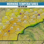
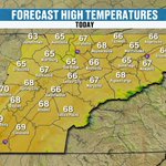
It's a chilly start, but not as rough as the last couple of mornings. No frost this time, though there's some patchy fog out there, so give yourself a little extra time if you're heading out early. Knoxville is at 39 right now, we're around 62 by lunch, and the afternoon tops out near 70 before easing to 65 around dinnertime.
Highs are upper 60s to low 70s pretty much everywhere, and the breeze won't be a factor.
Honestly a really nice day to get outside.
Locally owned and operated, AA Air with @centralcityhvac. Serving the greater Roane County and Knoxville Metro area, keeping you in your Comfortable Zone for over fifty years… visit your comfortable zone (dot) com or call 865-213-1354
@centralcityhvac; keeping you in your Comfortable Zone for over fifty years
@aaaircompany


3
126
Winter's First Warning Shot! Mountain Snow and a Sunday Hard Freeze. teapawt.net/i/broadcasts/2onzdqmAZ…

3
202
We are going to see some precipitation out of this system, which is good, because when we look above and beyond the 7-day forecast, we are looking at relatively drier than average conditions.
So we're going to be trending colder and drier than average back behind the system. And above and beyond the 7-day forecast, the Climate Prediction Center has been predicting the potential for those above average temperatures as well.
That's kind of the story: a midweek storm coming through, some frost to start the day, and I think that's going to be the story all the way through the week and even more so into the upcoming weekend.
@MonsterTreeServiceofKnoxville
Without leaves, structural problems are easier to identify. Dead branches, weak or damaged limbs, cracks, and hazardous trees can become especially dangerous when exposed to strong winds, heavy rain, ice, and winter storms common to East Tennessee.


3
371
Any chance of snow, the 12th through the 14th?
The ensembles are picking up on a good shot for some snowfall to occur across the mountains.
On average, about a half an inch of snowfall is looking more probable than anything else, but we could potentially see maybe upwards of about an inch of snowfall.
I'll keep you updated so check back in.
* MEDIC is the primary blood product provider for 24 hospitals and emergency air and ground transport services across 23 counties in East Tennessee and Southeast Kentucky.
* 1 in 7 of us will need a blood transfusion in our lifetime.
* Only 3% of eligible donors donate blood products.
•The shelf life for red blood cells is 42 days. The shelf-life for platelets is 5-7 days.
@medicblood


So, is snow possible?
The spine of the Appalachians looks like it's going to really get the snowfall with this one. Up towards West Virginia we've got Snowshoe, Mount LeConte, Clingmans Dome. Those areas are going to see some snow likely out of the situation.
What about the Plateau and the valley? Likely not the case, maybe a few snowflakes across the Cumberland Plateau.
When we're talking about the classic horseshoe, that's what we're going to be talking about this winter.
This is the higher terrain across the area, which has a better chance of seeing some snowfall in the wintertime.
Improving the lives of the people we serve
The @mcnabbcenter is the region’s leading nonprofit provider of mental health, substance use, social and victim services. We provide a quality and compassionate approach to care from infancy through adulthood.


So, the probability of snowfall Thursday night at 7:00 may start to increase Thursday into Friday morning, the chance for snow anyway across the mountains. That's going to be the story all day Friday across the highest peaks. Then as we get into Friday into Saturday, we'll start to lose that chance, and the snow machine kind of quiets down and comes to an end.
@MasterbatteryKnoxvilleTN
Master Battery serving Knox and surrounding communities for over 40 years. We now offer mobile installation services that allow us to come to you when battery has failed. We have what you need when you need it. Master Battery is the home of the best price, Guaranteed! So why pay more when you don’t have to.
Let's map it out for you.
Here's Wednesday, 5:00 in the evening, and here comes our cold front.
It's going to come through Wednesday night, Thursday morning time frame.
But notice the wraparound moisture.
Watch this. We're going to see the blue showing up across the higher elevations, the spine of the Appalachians.
@KnoxMission @KARMStores
Knox Area Rescue Ministries is a Christ-centered nonprofit dedicated to serving the homeless and vulnerable in the Knoxville area. Through shelter, meals, recovery programs, and supportive services, KARM works to restore lives with compassion, dignity, and hope.
Precipitation-wise, we're pumping it up to about a 60 to 80% chance of rain now for our Wednesday, Thursday time frame. I keep saying Wednesday, but Thursday. That storm system is going to move through on Wednesday, bringing us some rain showers, and it also has the potential of bringing us some snow showers, mainly across the higher terrain. This is not an official forecast by any stretch.
At @burks&ogle we’ve built a reputation for delivering strong outcomes. Our attorneys combine experience, focus, and a personal approach to every case we take.
We make sure you understand your options from the start. Then we help you build a clear, proactive strategy designed to win.


2
288
Yesterday we had temperatures in the 60s and 70s, and Chattanooga made it into the 70s, so it really turned out to be fantastic. Today a few pockets of 60s and 70s again, and the wind is not going to be an issue. That changes as we get into our Wednesday, when that cold front comes through and ushers in that drier, cooler air mass from Canada. Your evening forecast: 63 by 5, 56 by 7.
East Tennessee Basement Waterproofing the right way. The American way.
@americanfwusa


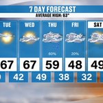
So, here's your 7-day forecast. We're going to be in the upper 60s today, Tuesday, and Wednesday. Then we drop into the 50s on Thursday, the 40s on Friday, and Saturday and Sunday we're going to be in the 40s and 50s. Those temps come back into the 60s as we get into next week.
@amelsecpa is a public accounting firm that serves businesses and individuals with Tax, Accounting/Bookkeeping, and Consulting needs. Our job is to make your job easier!

Saturday and Sunday are going to be the coldest mornings, where we actually have the potential for a hard freeze.
The average low temperature on Saturday by the ensembles is hovering right around 30 degrees.
When you look at our chance for a freeze, we're still looking at about a 60 to 80% chance for a freeze, and a hard freeze looks possible across some of the higher terrain. So again, it is still trending colder back behind the system.
@volunteerhomemortgage
You need a guide to lead you through the mortgage process so you can focus on finding the home you've been waiting for.


Here's that deep trough that's coming through during the middle part of the week, and that's going to set up shop and stick with us through the weekend. So here's our next shot of colder air. Low temperatures come up as the cold front approaches, and then they fall off. Notice Friday we're down to about 38. But notice Saturday and Sunday, those are going to be the coldest mornings.
@tnstandard is locally owned and operated by Kelton Balka, a fifth generation master plumber. He is a big believer in taking care of his customers which is why Tennessee Standard has thousands of five star reviews. If you’ve got an annoying plumbing issue, give him a call or book online on his website, tnstandard.com, he’d love to help you out.


Happy Monday, everybody.
This morning we start off with temperatures in the 30s, with a few pockets of near 40 across the southern valley, so a really nice quiet start to the day.
Temps are trending warmer this morning than what we were yesterday.
By lunchtime we're going to be in the low 60s, and when the kids are heading home from school, we're going to be in the mid 60s.
Above average weather is expected for the day today.
The wind is not going to be an issue today, but it will gradually increase as we get into Wednesday as that cold front comes through.
If you have evening plans tonight, it's 63 by 5 and 56 by 7.
@ruralmetrofiretn Rural Metro Fire Department has proudly served Knox County since 1977! We are funded solely from memberships with property owners but respond to everyone! Unfortunately those non-members will be billed for that service and it can be expensive. Avoid those high expenses, support your community Fire service and be invested in emergency services. Call 865-321-8613 for membership questions.


November Changes Settle In This Week! teapawt.net/i/broadcasts/2ReMdRKlB…

3
272
The Climate Prediction Center is finally picking up on that colder weather that's going to settle in as we get into next weekend. But above and beyond the 7-day forecast, in the 8 to 14 day outlook, they're also bringing back warmer than average temperatures. Lots going on here, and I'm going to continue to fine-tune it, so make sure you check back in each and every day as we get into next week.
Quick Lane Tire & Auto Center
Summer miles can add up. Get your vehicle ready for the road ahead at @rayvarnerford Quick Lane Tire & Auto Center. Schedule your service at stop by anytime


7
740
We'll go with a 40% chance of some precipitation on Thursday, and some of that is going to be in the form of frozen precipitation. Then we knock that down to about 20% on Friday, and the colder weather sets in Saturday into Sunday. Above and beyond the 7-day forecast, 6 to 10 and 8 to 14 days out, we may start to trend on the drier side.
@MonsterTreeServiceofKnoxville
Without leaves, structural problems are easier to identify. Dead branches, weak or damaged limbs, cracks, and hazardous trees can become especially dangerous when exposed to strong winds, heavy rain, ice, and winter storms common to East Tennessee.


Here's any chance of snow, November 12th through the 14th, again sticking with the ensemble forecast
It's about a 10% chance at best across the Plateau.
The best chance is going to be across the Smoky Mountains, where we're running about a 40 to 50% chance across the higher terrain.
The average snowfall, if we get it, is about a half an inch across the highest peaks, so it's not looking like a huge snow maker by any stretch of the imagination.
The high-end forecast could be upwards of an inch to 2 inches.
Welcome to these kinds of storm systems.
Come to a trusted source, and make sure you read the text as well.
This is not an official forecast by any stretch.
* MEDIC is the primary blood product provider for 24 hospitals and emergency air and ground transport services across 23 counties in East Tennessee and Southeast Kentucky.
* 1 in 7 of us will need a blood transfusion in our lifetime.
* Only 3% of eligible donors donate blood products.
•The shelf life for red blood cells is 42 days. The shelf-life for platelets is 5-7 days.
@medicblood


Notice how the probabilities start to increase throughout the day on Thursday.
The cold front is off to our east, the wraparound moisture starts to come in, and the probabilities for seeing any sort of snow start to ramp up across the higher terrain. Then as we get into Friday evening, there's a little bit of a chance for some light snow showers across the Plateau.
Make sure to check back in this week to see how things evolve.
Improving the lives of the people we serve
The @mcnabbcenter is the region’s leading nonprofit provider of mental health, substance use, social and victim services. We provide a quality and compassionate approach to care from infancy through adulthood.
So is snow possible around the region?
Yeah, it's possible.
It's not looking as intense as it was yesterday, and I think this model guidance has a much better handle on what we could see.
Right along the spine of the Appalachians, from West Virginia down to the Tennessee and North Carolina border, that's where I think we have the greatest potential for some light snow showers.
Now, notice the classic horseshoe shape around East Tennessee, with the higher terrain across the Plateau and the Smokies. You're going to hear me talk about that a lot this wintertime. The horseshoe effect is what we call that here in East Tennessee.
This is not an official forecast by any stretch.
@MasterbatteryKnoxvilleTN
Master Battery serving Knox and surrounding communities for over 40 years. We now offer mobile installation services that allow us to come to you when battery has failed. We have what you need when you need it. Master Battery is the home of the best price, Guaranteed! So why pay more when you don’t have to.


Let me walk you through our radar depiction, our Futurecast. It's likely to bring us some rain showers on the leading edge of the cold front, and then on the backside, we'll probably get some wraparound moisture. But then here comes the colder air. Our best potential for seeing any sort of frozen precipitation, at this point of the game, is going to be across the higher terrain and the northwest-facing slopes. This is not an official forecast by any stretch.
@KnoxMission @KARMStores
Knox Area Rescue Ministries is a Christ-centered nonprofit dedicated to serving the homeless and vulnerable in the Knoxville area. Through shelter, meals, recovery programs, and supportive services, KARM works to restore lives with compassion, dignity, and hope.
3
394