

Official Twitter Account for National Weather Service Wilmington OH. Details: https://xitter.cf/t.co/IijUOKg61A
- Tweets28.2K
- Following93
- Followers55.2K
- Likes3K




ALT Two graphs; one showing temperatures slightly above normal, and a second showing precipitation chances this weekend.

ALT Maps showing forecast highs and lows today, Monday, and Tuesday.

ALT Two graphs; one showing temperatures slightly above normal, and a second showing no precipitation through the week.

ALT Map showing that a dense fog advisory is in effect for Hardin, Auglaize, and Mercer Counties through 10 am.

ALT Two graphs; one showing temperatures slightly above normal, and a second showing no precipitation through the week.

ALT Two graphs; one showing temperatures slightly above normal, and a second showing no precipitation through the week.

ALT Two graphs; one showing temperatures slightly above normal, and a second showing no precipitation through the week.

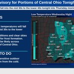
ALT A graphic showing temperatures ranging from the mid 30s to the lower 40s overnight.

ALT Maps showing forecast highs and forecast lows over the region for today through Friday.


ALT Maps showing forecast highs and forecast lows over the region for Tuesday, Wednesday, and Thursday.

ALT Maps showing forecast highs and forecast lows over the region for Tuesday, Wednesday, and Thursday.

ALT Low temperatures tonight in the middle 30s to lower 40s could result in patchy frost.

ALT Graphs showing forecast temperature and forecast chance of rain averaged over the area through Saturday.

ALT A graphic showing temperatures in the mid to low 30s Sunday night.

ALT Maps showing forecast highs and lows across the area Sunday, Monday, and Tuesday.
