

⚠️ Analysis of the skies of Chicagoland!
Chicago, IL
Joined June 2016
- Tweets2.2K
- Following769
- Followers2K
- Likes1.6K

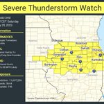


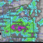


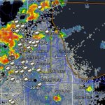


⚠️A severe thunderstorm watch has been issued for parts of Illinois, Indiana and Iowa until 2 AM CDT; includes city of Chicago!

144
Watching the potential for very strong storms this evening. Currently looks like the window for this activity is 11pm-12am.

A line of thunderstorms is moving eastward through Northern Illinois at 50 to 60 mph. This line is producing locally heavy rainfall and frequent lightning with the potential for strong wind gusts up to 70 mph!
ilwx #wiwx
207


⚠️A Severe Thunderstorm Warning continues for southern portions of Chicago, IL until 7:00 PM CDT. This storm will contain wind gusts to 70 MPH! #ilwx
1
395
Ongoing thunderstorms will continue through mid evening with some becoming severe. #ilwx
1
150
Thunderstorms are starting to take shape across northern Illinois and the Chicago metro! Storms are expected to persist through at least 8 PM CDT with few possibly becoming strong to severe with gusty winds and heavy downpours as the main threats.
50
Thunderstorms are expected this afternoon across the area. A general window of 12 to 8 PM through this evening is expected best timing!
39
⚠️The Illinois Environmental Protection Agency has determined that an Air Pollution Action Day will be declared for Wednesday July 5th for the greater Chicago Metropolitan Area through Wednesday night.

Spotty t-storm development remains possible through ~6 PM CDT especially in the indicated area below, though storms have struggled to get going so far.

71
Radar estimates and rainfall reports from personal weather stations and rain gauges indicate that widespread 3-7" rainfall totals occurred across central Cook County, with some localized totals higher than 8"!

3
245
⚠️Flash Flood Warning including Chicago IL, Joliet IL and Naperville IL until 1:15 PM CDT. Check your basements Chicago!
KLOT - Super-Res Reflectivity 1 09:42 #ilwx
1
622
⚠️Flash Flood Warning including Chicago IL, Joliet IL and Naperville IL until 1:15 PM CDT. Check your basements!
93
