RyanWeather.Com (@Ryan541) header
RyanWeather.Com (@Ryan541) profile picture

Southern Oregon and Northern California weather updates. My website links to weather data live from Medford, Oregon. Hourly weather updates 24/7/365.

Medford, Oregon
Joined April 2009
Photo by RyanWeather.Com (@Ryan541)Photo by RyanWeather.Com (@Ryan541)Photo by RyanWeather.Com (@Ryan541)Photo by RyanWeather.Com (@Ryan541)Photo by RyanWeather.Com (@Ryan541)Photo by RyanWeather.Com (@Ryan541)Photo by RyanWeather.Com (@Ryan541)Photo by RyanWeather.Com (@Ryan541)Photo by RyanWeather.Com (@Ryan541)Photo by RyanWeather.Com (@Ryan541)
A beautiful morning view in Lake County from the Fish Creek Rim webcam.
14
409
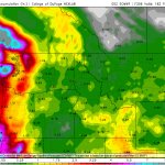
A look at where measurable precipitation is most likely to develop through 5 AM Friday morning across our forecast area.
1
8
159
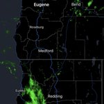
Radar returns this morning are showing showers moving mostly into Northern California.
1
5
136
High temperatures today will still trend a few degrees below normal. Here are the latest GFS model projections across the region.
2
4
189
Another day of clouds across the region as a front moves inland to our south and spreads showers into Northern California. This is where the highest potential for measurable rainfall is today.
1
7
195
Atmospheric River Expected to Affect the West Coast states
40
172
31
1,496
204,940
NWS Medford: “Dry conditions are expected through Monday. Rain chances return on Tuesday with a system moving into the area. Northern California and coastal areas have higher rain chances, while west side valleys and areas East of the Cascades have lower rain chances.”
10
299
RyanWeather.Com retweeted
😮Wow, just wow. Check out the SSTs. Crazy warm water (65°–75°F+) is surging N from SoCal right into the Central Coast. That means warmer beach nights, elevated tide levels, and wild marine life shifts! #cawx #ElNiño
9
82
5
440
35,293
It is a chilly morning at Crater Lake National Park, but the Sinnott Overlook webcam is capturing an earlier sunrise, post daylight saving time.
1
24
463
We will warm a few degrees today but still remain slightly below normal. Here is a look at the latest GFS model run projections for the entire region.
1
10
312
Satellite imagery this morning shows areas of clouds streaming overhead. Most of these are high and mid level. There are a few areas of low clouds and fog in the western interior valleys.
9
346
The European weather model is showing some very heavy rain and higher elevation snowfall potential. Estimates are still all over the place with each run. Confidence in seeing these amounts materialize is low at this time. It is worth keeping a close eye on however.
1
11
469
We are likely to see more fog and freezing fog overnight into tomorrow morning. Here is a look at where the risk is highest across the region.
2
10
362
We do have fresh snowfall on the Steel Visitor Center at Crater Lake and the Mt. Ashland lodge webcams this morning.
2
1
41
659
Another cooler than normal day is on tap across the region. Here are the latest GFS model run projected highs across the region.
2
9
269
Areas of fog and low clouds have developed overnight both east and west of the Cascades. You can see this quite well on the visible satellite imagery. Some areas are seeing dense freezing fog as well.
1
8
305
We are seeing some measurable rainfall this evening as showers continue to move across portions of the region. Here are the latest 24 hour precipitation amounts.
7
330
Radar is picking up on showers moving inland this afternoon. Here is a look at where they are currently focused.
6
234
A look at the most current precipitation estimates in terms of rain and snow through early Tuesday morning. Overall we are looking at very light amounts across the region.
7
317
It is a cool start to the morning with areas of frost and freeze conditions both east and west of the Cascades. Here are the current temperatures as of 7 AM.
2
6
258