

This feed is for fun and does not reflect the views of State College Area School District - The Weather Prognosticators of State High
State College, PA
Joined December 2016
- Tweets370
- Following28
- Followers588
- Likes292




SCAHSPrognosticators retweeted

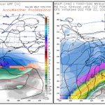
Both major Hi-Rez models seem to have a pretty significant front end snow thump before a change over to mix and eventually some drizzle for parts of the Hudson valley lower Hudson Valley mid Hudson valley north New Jersey in northeastern Pennsylvania into New England


SCAHSPrognosticators retweeted

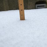
2 to 3 inches of snow across central PA. Roads are snow covered and icy.

SCAHSPrognosticators retweeted
⏲️STORM EVOLUTION⏲️
❄️Rain changes to snow quickly at onset
⏬Occasional heavy snowfall rates of 1"+ per hour can cause snow to stick on roads, even if temperatures are several degrees above freezing
🌧️Plain rain in the southeast
🔴Precipitation exits NE late tonight
#PAwx
(3/6)
SCAHSPrognosticators retweeted

Latest snowfall forecast has been widely upped region wide with as much as a foot of snow expected in higher terrain in New York!
Overall snowfall will heavily be elevation dependent but a very solid mid spring snowstorm for many!

SCAHSPrognosticators retweeted
First call looking at precipitation types for the latest storm threat late week.
It looks to be mostly an interior snow event in NY/NE with much sloppier precipitation types closer toward the coast and further SW. Going to be fun tracking this one!

SCAHSPrognosticators retweeted
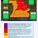
Thursday-Friday: Winter Storm Potential for PA
❄+4" of snow possible north of I-80
🧊 >0.25" ice possible in Laurel Highlands, trace to a few tenths elsewhere
🌨For more detailed info for this complex event visit weather.gov/ctp/winter
#PAwx


SCAHSPrognosticators retweeted
Sincerest apologies for the improper labels on the previous graphic. We've fixed the graphic and updated the forecast to reflect our latest thoughts. #PAwx

SCAHSPrognosticators retweeted

Tomorrow, Friday, Feb. 4, district schools will be closed due to forecasted icy conditions. The day will be made up on April 18.

SCAHSPrognosticators retweeted
Curious about when rain, ice, sleet, and/or snow will arrive at your location?
Check out our Weather Type Forecast and use the buttons at the bottom to click through the next few days!
➡️weather.gov/ctp/winter#tab-8
#PAwx


SCAHSPrognosticators retweeted
Two Scenarios have presented themselves in modeling.
First the warmer, more amplified scenario which would give northern interior areas a major snowstorm with interior regions an ice storm.
Then the colder scenario where interior regions get snow with coastal ice.


SCAHSPrognosticators retweeted
Tomorrow, Tuesday, Jan. 18, district schools will start with a two-hour delay due to road conditions from freezing and drifting snow, especially in the outlying areas.

SCAHSPrognosticators retweeted
Snow will overspread the area from south to north Sunday PM. A changeover to a wintry mix will occur from SE to NW across the area Sun night, and a period of plain rain is possible in the Susq Valley. Precip will taper off Mon AM, with lingering lake-effect across NW PA. #ctpwx

SCAHSPrognosticators retweeted
Today, Jan. 7, district schools will start with a two-hour delay due to snowy road conditions.

SCAHSPrognosticators retweeted
⏲️Snow will begin in SW PA in ~24 hours.
⚠️Winter Weather Advisory issued Thu PM - Fri AM.
🚗Travel impacts most likely Thu PM & Fri AM, mainly in southern PA.
👀Subtle changes in forecast snow amounts are guaranteed. 𝐏𝐥𝐞𝐚𝐬𝐞 𝐜𝐡𝐞𝐜𝐤 𝐛𝐚𝐜𝐤 𝐟𝐨𝐫 𝐮𝐩𝐝𝐚𝐭𝐞𝐬.
#PAwx

SCAHSPrognosticators retweeted

It will take 2 storms but heck of a week of winter weather for the ne coming. IN 1996 it was 1


SCAHSPrognosticators retweeted
A winter storm watch remains in effect for much of central PA for accumulating snow beginning late tonight and ending Fri morning. Expected amounts range from 2-4 inches in the northwest to 6-9 inches in the southeast. Snow may be heavy at times tomorrow #PAwx
