

🌍🛰️ Remote Sensing and Spatial Data Science at German Aerospace Center, Geonerd.
Rosenheim, Deutschland
Joined February 2018
- Tweets36
- Following164
- Followers109
- Likes292




Sandro Groth retweeted

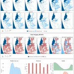
Great PICO poster @SpatialSandro
💧Water segmentation and unet algorithms #EGU24 #remotesensing
~geoservice.dlr.de/web/


Happy to present insights to our work on hydrological drought mapping from space at the #EGU23. More to come in the next months!
Link to our Abstract: doi.org/10.5194/egusphere-eg…


Sandro Groth retweeted

Zwei der vier Gaslecks in der Ostsee an der Pipeline #Nordstream1 - eingefangen vom @CopernicusEU-Satelliten #Sentinel1A am Abend des 29. September. 🛰
Der Radarsatellit kann die Meeresoberfläche durch Wolken und Nebel hindurch abbilden - bei Tag und Nacht. 🌙

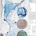
@WHO warns of major water- and vector-borne disease outbreaks amid the historic #PakistanFloods due to long-lasting flood water. We at @DLR_de #ZKI used satellite data to generate a flood duration map to support emergency response in identifying affected areas.

The product is based on 117 @CopernicusEU #Sentinel-1 images taken between 1st of August and 5th of September and complemented by a seasonal reference water mask to distinguish between "normal" water extent and floods. More information at: activations.zki.dlr.de/de/ac…
Sandro Groth retweeted

Das Deutsche Zentrum für Luft- und Raumfahrt (@DLR_de) in Oberpfaffenhofen bietet nun einen Service im Netz an, mit dem Waldbrände tagesaktuell und im zeitlichen Verlauf beobachtet werden können. Der Dienst ist für alle kostenlos. Wie das funktioniert. sz.de/1.5643294?utm_source=T…
Happy to share our work on a global seasonal and permanent reference water product based on #Sentinel2 and #Sentinel1 for improved #flood mapping, which was recently published in RSE:
authors.elsevier.com/c/1f5Mg…

Sandro Groth retweeted

Great to see so many of our #eagle students and staff members at #lps22 @eo_wuerzburg @Uni_WUE #earthobservation #remotesensing - photo via @lalsdestiny

Sandro Groth retweeted

New high-res #satellite imagery (10:36 am local time, August 16) of the chaotic scene underway at #Kabul’s Hamid Karzai International Airport in #Afghanistan as thousands of people converged on the tarmac & airport runways as countries attempt to evacuate personnel from the city.


Sandro Groth retweeted

The @IPCC_CH report is stark and upsetting; it tells us unequivocally that human activity has warmed the atmosphere, ocean and land, and we are only years away from going beyond the 1.5 degree warming limit agreed by world leaders.
Sandro Groth retweeted

Today we are releasing the Open Buildings Dataset, a new open-source dataset containing the locations and footprints of >500M buildings with coverage across Africa, which can support numerous scientific and humanitarian applications. Read more at goo.gle/3751HVR

Sandro Groth retweeted

We provide our first workshop on how journalists can use #RemoteSensing for their work. For this workshop we are using the @sentinel_hub's EOBrowser and the data from @ESA_EO. The workshop will be conducted in German. Feel free to join us 🛰

Besonders für Klimathemen sind Satellitendaten nützlich: Waldbrände, Küstenlinien, Agrarflächen. In unserem kostenlosen CORRECTIV.Lokal Workshop am 27.05 mit @niklas_jordan lernst du, wie du diese Daten für deine lokale Berichterstattung nutzen kannst. correctiv.org/lokal/workshop…
Sandro Groth retweeted

🔴 With support of @EUSPACEIMAGING we have finally integrated @Maxar's #WorldView data. Check our 🆕 #SentinelHub blog post ➡️
medium.com/sentinel-hub/ther…
#neverenoughdata 🛰️🛰️🛰️😃 #remotesensing #EO

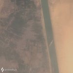
Something got stuck here.. Massive container ship blocking the #SuezCanal, caught by @CopernicusEU #Sentinel-2 satellite.
Images downloaded from @sentinel_hub
#EarthObservation #RemoteSensing


Big ship queue forming, as seen by #Sentinel-1 radar satellite, which luckily also had an acquisition today.

Update: Traffic jam is definitely getting worse.
#Sentinel-1 Images, Credits: @sentinel_hub:


Sandro Groth retweeted

Here it is! The first processed image you see below displays #Sentinel6 sea level anomaly data! To find out more about the first altimeter data collected by #Sentinel6 Michael Freilich, visit: bit.ly/3m18uF3

Sandro Groth retweeted

LIFTOFF🚀🛰️!
#Sentinel6
Tune into esawebtv.esa.int to follow the live transmission and follow @esaoperations for more detailed updates 🕹️
Sandro Groth retweeted

Phi-sat-1 - a satellite with #AI on-board performing cloud mask in Space! This experiment announced two years ago at #phiweek was an important experiment to understand & start exploring the potential of #AI, deep learning and processing in Space.
🔴 phiweek.esa.int

Sandro Groth retweeted

90% of programming is asking the right question so the answer shows up on page 1 of Google’s search results
Sandro Groth retweeted

Mapped: Global warming – past and future – at a local scale carbonbrief.org/mapped-how-e…
#Climate #Temperature #GlobalMap