

Former weatherman for @BTW21LIVE to Weekend Weather Forecaster @WITN. Photography and hiking a hobby. @Nike is my Motto, “Just Do It”
Joined January 2015
- Tweets5.2K
- Following556
- Followers314
- Likes10.5K




We will see a blend of clouds and sunshine, as well as a few light passing showers at times. Temperatures will be in the upper 60s to low 70s, and lows in the 40s and 50s.
More sunshine returns for Election Day Tuesday & Wednesday. #NCwx
As we start November, temperatures will feel closer to average, with highs in the 70s today & Monday. Lows will be in the 40s and low 50s. Clouds depart later Monday and skies clear Tuesday morning.
We start a warm up in time for Election Day. #NCwx
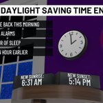
If you are waking up this morning and thinking you slept in later, no worries! We received an extra hour of sleep as we gained an extra hour of sleep last night.
Be sure to turn the clocks back one hour this morning if you forgot. Also, change the smoke detectors batteries.


Happy Halloween, ENC! Our spook-tac-u-lar dat will feature all treats, no tricks for the Halloween weekend. A mix of clouds and sunshine remains, with highs in the 70s, and lows in the 50s. Northeast winds will subside into Sunday.
Clouds linger into Mon.
We will see a nice and warm afternoon, with temperatures in the 70s, northeast breezes around 10-20 mph, and lows in the 50s.
The continued warmth remains through Friday and into Halloween. Winds relax as well, as the King Tide ends Saturday. #NCwx
The same song and dance continues into this afternoon and over the next several days. We will be in the 70s to near 80°, winds slowly relaxing, and lows in the upper 40s and low 50s.
Coastal areas will need to continue to watch for flooding. #NCwx
Continue to enjoy the ongoing fall weather over the next few days, as skies will be calm and quiet. Temperatures will be in the 70s and lows in the upper 30s and lower 40s tonight. Not a widespread frost, but a cold start to Tuesday morning. #NCwx
The same song and dance remains into the last Sunday of October, but also watch for northeast breezes, which could impact coastal areas thanks to the King Tide this week. Flood alerts are issued until Wednesday afternoon.
We are in the 70s as highs. #NCwx
Get out and enjoy the fall-air this weekend, with a mix of clouds and sunshine, and temperatures in the 60s and 70s. Lows fall to the 50s, as we will see mix of clear skies and clouds.
A copy and paste forecast remains for Sunday.
Staying dry into Monday.
The fall air will be the theme to end the week out, with northeast winds relaxing. Highs will top out in the upper 60s and low 70s.
After waking up into the upper 40s and low 50s, plenty of sunshine lingers across ENC. We hold in the upper 60s and low 70s.
Another dry and fall day will continue into the afternoon across ENC remains, with highs in the upper 60s and low 70s. Winds will relax, but a light breeze along the coast continues.
More of the same into Friday and the weekend, as winds increase. #NCwx
A temperature whiplash is underway in Eastern NC this weekend, as a cold front will bring showers, northerly wind, and a blast of chilly air for Sunday morning.
Are you ready for a true, fall feel?

For the summer weather fans, this is your time to enjoy the afternoon, with highs in the upper 80s to near 90°. A mix of sun and clouds remains, with lows falling to the 70.
A cold front brings showers, gusty winds, and cooler temperatures this weekend.
The late season summer pattern will remain into Friday, with highs in the upper 80s to near 90°, as record highs are possible. Winds out of south will make it feel humid. Lows fall to the 60s.
A cold front moves in this weekend, with a drop in temps.
The cool and crisp afternoon will continue across Eastern NC on this Monday, with a mix of clouds and sunshine, and temperatures in the 70s and low 80s. Quiet skies remain tonight, with lows in the 50s and 60s.
Comfortable Tuesday; Late week warm up. #Ncwx
A Tornado Watch is issued for parts of Eastern North Carolina until 5 PM Sunday. Most of the active weather has remained out to the west of I-95 to central NC. No active waning's here in ENC, but heavy rain from a cold front arrives this afternoon. #NCwx
For the rest of your Saturday, the remnants of Isaias will continue to pass by Eastern NC, giving us a chance of heavy rain and possible flooding tonight.
A slight risk of severe weather is in place for Sunday, as cold front will spark more rain. #NCwx

Our overcast and warm day will continue this afternoon, with highs will be in the 70s, and lows in the 60s.
More clouds in the morning, as we have in the lower 70s, but rain chances increases in the afternoon. Heavy rain filters in through Sunday. #NCwx