

Official account of the United Nations Satellite Centre - UNOSAT, UNITAR, imagery analysis, #satellite solutions, #GIS
Geneva, Switzerland
Joined May 2010
- Tweets7.4K
- Following869
- Followers13.1K
- Likes6.7K




🌊Floods in #Senegal: @UNOSAT released new satellite flood mapping to support @OCHAROWCA , following the activation of @DisastersChart.
➡️unosat.org/products/4262
#Senegal #Floods #WestAfrica

@UNOSAT activated emergency mapping and triggered @DisastersChart on behalf of @UNDP to support emergency response to the M7. 7 #earthquake that struck 12 km WSW of Pitaloza Arriba, #Panama, on 09 October 2026.
@UNDP @Earthquake
@UNOSAT has been activated @DisastersChart in response to #Nepal Budhi Gandaki river mudflow and floods to support @OCHA emergency operations.
Initial findings from satellite imagery analysis are now available on the live webmap:
➡️unosat.org/products/4263

An important milestone for children in Timor-Leste! The Government of Timor-Leste has launched the CCRI-DRM Report and Geospatial Platform, led by the Ministry of Finance and INETL, with support from UNICEF and @UNOSAT.
@UNITAR_ED @UNITAR @UNICEFTL

Timor-Leste CCRI-DRM is launched!
The platform identifies where children face climate and disaster risks across all 13 municipalities. Drive smarter planning & stronger resilience.
🗺️ shorturl.at/bxZJI
@UNTimorLeste


UNOSAT retweeted

Timor-Leste CCRI-DRM is launched!
The platform identifies where children face climate and disaster risks across all 13 municipalities. Drive smarter planning & stronger resilience.
🗺️ shorturl.at/bxZJI
@UNTimorLeste
UNOSAT retweeted

Pleased to meet Greek PM @PrimeministerGR @kmitsotakis
at #ParisSpaceSummit. We discussed cooperation with @UNOSAT @UNITAR, bringing Greek Earth Observation expertise & public–private partnerships to support Member States, humanitarian action and climate resilience. @UNITAR_ED

UNOSAT retweeted
Space cooperation must deliver for people.
Proud to sign the Space for Climate Observatory Charter for @UNITAR at #ParisSpaceSummit, bringing 25 years of @UNOSAT expertise to turn satellite data into decisions that protect lives & build resilience.
@UNITAR_ED @CelineJurgensen


UNOSAT retweeted

#ParisSpaceSummit | 👏 @UNOSAT pour la signature de la Charte internationale de l'Observatoire spatial pour le climat
Plus de 40 pays et organisations travaillent ensemble pour mettre l’espace au service du bien commun et de l’action climatique. Une avancée majeure ! 🌍🛰️

@UNOSAT has released initial estimates of flood and landslide extent in Rasuwa district, Nepal, using Sentinel-2 & Planet imagery to support damage assessment & coordination of relief efforts on the ground.
➡️: unosat.org/products/4257
#Nepal#DisasterResponse#SatelliteImagery

@UNOSAT is supporting the response to devastating floods and landslides in Nepal, providing satellite-based damage assessments to guide relief efforts on the ground.
Initial analysis for Rasuwa & Nuwakot districts based on Sentinel-2 & Planet imagery.
➡️unosat.org/products/4258

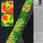
Analysis by @UNOSAT, supporting the oPt Education Cluster's response in Gaza, indicates ~ 44% of potential kindergarten and school-aged students remain unreached.
Consult here:
unosat.org/products/4249
unosat.org/products/4248
@GlobalEdCluster @ochaopt @UNICEF @save_children

Following the International Charter activation for #Bangladesh, our FloodAI Dashboard is continuously monitoring flood conditions and providing up-to-date exposure statistics to @WFP and other humanitarian partners.
unosat.org/products/4246
@Bangladesh @WFP @DisastersChart

Damage analysis for the 24 June 2026 #Earthquake is now available for El Cambur, El Castaño and Taborda south of Puerto Cabello, using VHR WorldView-3 imagery provided by @DisastersChart and analysed by @UNOSAT.
@abae_ve @onuvenezuela @ONUVEGinebra @ONUVENuevaYork @UNOCHA

Consult and download the related geodata from the @UNOSAT live web map and for updates on ongoing satellite-based analysis:
experience.arcgis.com/experi…
@abae_ve @onuvenezuela @ONUVEGinebra @ONUVENuevaYork @UNOCHA
We have been activated to support emergency operations related to the 24 June 2026 #earthquake in #Venezuela.
Consult SMCS for satellite-based analysis: smcs.unosat.org/event/417
@onuvenezuela @ONUVEGinebra @ONUVENuevaYork @UNOCHA @DisastersChart @noradno @MFA_Lu @GDACS

Consult our webmap related to the #earthquake in #Venezuela here: experience.arcgis.com/experi…
Our upcoming analysis will be released on the #UNOSAT portal: unosat.org/products/
@GAC_Corporate @onuvenezuela @ONUVEGinebra @ONUVENuevaYork @UNOCHA @DisastersChart @noradno @MFA_Lu
🌍 UN Satellite Centre rosters are open:
🛰️ Geospatial Analysts (GVA)
bit.ly/4cWy5N9
🧠 QA/QC & Training Specialists (GVA) bit.ly/42h4OGX
🛰️ Geospatial Analysts (Remote) bit.ly/3QM9bY6
🧠 QA/QC & Training Specialists (Remote) bit.ly/4eyHWdg

UNOSAT retweeted

First 48 hrs after a crisis matter.
Today in Geneva, Shoko Noda @shokonoda & Michelle Gyles-McDonnough @UNITAR_ED launch a strengthened partnership between @UNDP and @UNOSAT to deliver impact analysis in 48 hrs.
Faster data = faster recovery
#DisasterResponse #SatelliteImagery


UNOSAT retweeted

When crises strike, the first 48 hours are key.
Today in Geneva, @shokonoda & Michelle Gyles-McDonnough @UNITAR_ED launch a strengthened partnership between @UNDP and @UNOSAT to deliver impact analysis in 48 hrs.
Faster data = faster recovery.
🛰️ go.undp.org/5ye
