

Verifiable Earth Observation Intelligence 🌍🛰 Free access to conservation and common good projects🌿 Join the waitlist ⬇️
Joined September 2026
- Tweets51
- Following13
- Followers40
- Likes3





Yapacana National Park in the Venezuelan Amazon covers more than 320,000 hectares of forest, tepui and white-sand savanna. There is no road network to speak of. A ranger patrol cannot cover it, and nobody is pretending otherwise.
One Sentinel-2 scene from January 2025, over a 1,163 km² window inside the park, returns four clusters with the signature of alluvial working: stripped ground plus turbid pond water, together, at a size that rules out natural clearings. One of them dominates — a single pitted, ponded site of the kind that does not occur naturally.
The interesting result here is the negative one. The frame contains a great deal of naturally bright ground — the white-sand savanna of the Guiana Shield looks, to a careless threshold, exactly like a mine. It is not flagged, because bare brightness alone is not the test; the ponding has to be there too. Finding nothing across the other 1,159 km² is what makes the four worth driving to.
This is the shape of the work for a protected-area authority. Not "watch everything". Reduce a thousand square kilometres to a short list, on a schedule, and spend the fuel budget on the short list.
Conservation and non-profit use of Zephyr is free. zephyr-space.com
#Conservation #Amazon #EarthObservation #Sentinel2 #ProtectedAreas #Venezuela #RemoteSensing

13
This is a post about a measurement that is correct and misleading at the same time, which is worth more than another chart.
Lake Kariba, on the Zambia–Zimbabwe border, is the largest artificial lake in the world by volume and it supplies most of the electricity for both countries. Through 2024 it fell to the lowest usable storage on record: 11.9% in July, 5.6% by mid-October, against 20.2% on the same date a year earlier. Zambia shut the Kariba North Bank power station in September.
Measured from orbit, over a 1,793 km² section: surface area fell from 1,036.6 km² in October 2021 to 957.0 km² in December 2024. Down 75.8 km². Down 7.3%.
Both figures are right. A reader given only the satellite number would conclude the lake is basically fine.
The reason is geometry. Kariba is a drowned gorge, not a shallow pan — steep sides, enormous depth. You can take out almost all of the usable volume and the shoreline barely moves. Surface area is a reasonable proxy for storage in a shallow reservoir and a terrible one in a deep one, and nothing in the imagery tells you which kind you are looking at.
So the discipline is: publish the area you measured, publish the storage figure from the authority that gauges it, and never let the first stand in for the second. Satellite area without bathymetry is not a volume estimate. The violet is real and the 7.3% is real — the crisis is about an order of magnitude worse than it looks.
Request access at zephyr-space.com
#Hydropower #WaterSecurity #EarthObservation #Sentinel2 #Energy #Africa #Drought

After a storm, an insurer may need flood extent on tens of thousands of parcels inside a week. A commodity buyer re-checks every supplier plot each quarter against deforestation rules. A pipeline operator monitors a corridor on every satellite pass, forever.
Nobody is going to notarise those one at a time.
That is the problem with most provenance schemes, and it is not a technical one. If recording where a result came from costs a decision — someone has to think this one matters, open a tool, sign something — then it happens for the flagship analysis in the annual report and not for the forty thousand assessments that actually moved money. And you cannot know in advance which result will be challenged. It is never the one you expected.
So the receipt is written by the pipeline, not by a person. Every run produces one the way every run produces a GeoTIFF. There is no selection step, because a selection step is where provenance goes to die.
Two things make that affordable rather than aspirational.
Commitments go out in batches, so the marginal cost of one more receipt is not a line item anyone has to defend in a budget meeting. And the person asking the question never sees any of it — you ask for flood extent, you get flood extent. No wallet, no gas, no extra step, no training.
Which means when someone asks two years later "was this one of the ones you recorded?", the answer is not a search through a log. It is yes, because there is no other kind of run.
zephyr-space.com
#EarthObservation #DataIntegrity #Provenance #Insurance #SupplyChain #RemoteSensing #FlareNetworks
@FlareNetworks

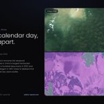
Two Sentinel-2 scenes over Poyang Lake, China's largest freshwater lake. Both are 6 September. One is 2020, the other 2022.
Water surface in the 2020 scene, across a 1,093 km² window: 761 km². The same window on the same calendar day two years later: 106 km². Down 86%. The violet polygon — lakebed that held water on that date in 2020 and did not in 2022 — covers 654 km².
Choosing the same calendar day is not a stylistic choice. Poyang is a flood-pulse lake: it swells with the Yangtze in summer and shrinks every winter by design, and a comparison across seasons produces a dramatic number that describes the calendar rather than the drought. Fixing the date removes that argument before anyone can make it, which is why the figure survives contact with a sceptic.
The context is not subtle. In 2022 the lake entered its dry season roughly a hundred days early and hit the lowest level since records began in 1951. Poyang is a Ramsar wetland and the main wintering ground for most of the world's Siberian cranes; it also buffers the middle Yangtze and supplies irrigation across Jiangxi.
Request access at zephyr-space.com
#Drought #WaterSecurity #EarthObservation #Sentinel2 #China #Wetlands #ClimateRisk

57
Every vendor in Earth observation will tell you they keep an audit trail. They do. They also control it.
That is not an accusation, it is a structural fact, and it is the one thing in this field that no amount of better science fixes. The imagery is open. The indices have been in the literature for decades. Two competent teams given the same question will usually land on the same answer. None of that helps with the question that actually gets asked in a dispute: is the answer I was handed in March the answer that existed in March?
Which scenes did it read. Which model version ran. Did a threshold move quietly afterwards. Those are all things a vendor can answer, and all things a vendor answers about itself.
So we stopped asking to be believed.
Every run folds the exact scenes it read, the operator chain, the model version and the result into a single digest, and commits that digest to a public ledger — where the clock belongs to a network with no interest in what we concluded. The record exists somewhere we cannot reach it. This is how audibility is granted.
zephyr-space.com
#EarthObservation #DataIntegrity #Provenance #Auditability #RemoteSensing #Geospatial #FlareNetwork

In May 2024 the Guaíba at Porto Alegre peaked at 5.33 metres, beating the 1941 record by 57 centimetres. More than 90% of Rio Grande do Sul's municipalities were affected and around 600,000 people were displaced.
Measured over a 1,042 km² window: 127 km² of ground that was dry on 24 March and under water on 21 May. Water already standing before the event — the Guaíba itself and the Jacuí channels — covered 165 km².
Separating those two numbers is the entire job. A flood map that counts the river as flood is worse than useless to a loss adjuster, because it is confidently wrong in a way that looks authoritative. So the pre-event water surface is computed first, dilated to absorb normal bank movement, and subtracted. Red is new water only.
You can see where it lands: the Jacuí delta islands, the Canoas and Esteio industrial belt, and the ground around the airport. Those are the polygons you intersect with a policy book, a building footprint layer, or a municipal boundary.
Request access at zephyr-space.com
#Flood #Insurance #EarthObservation #Sentinel2 #DisasterResponse #Brazil #ClimateRisk

45
After a flood the hard question is not where the water is. It is which water is new.
Sindh, Pakistan, in the 2022 monsoon. Red is water present in the September scene and absent in May — 9.68% of this window. Blue was already standing in the dry-season image.
Telling them apart is the entire job. An inundation figure that quietly counts lakes and irrigation storage is not conservative, it is wrong, and it is wrong in the direction that sends people and money to the wrong district.
Zephyr is in early access — request access at zephyr-space.com
#EarthObservation #RemoteSensing #Sentinel2 #FloodMapping #Pakistan #HumanitarianTech #DisasterResponse

16
Every vendor in Earth observation will tell you they keep an audit trail. They do. They also control it.
That is not an accusation, it is a structural fact, and it is the one thing in this field that no amount of better science fixes. The imagery is open. The indices have been in the literature for decades. Two competent teams given the same question will usually land on the same answer. None of that helps with the question that actually gets asked in a dispute: is the answer I was handed in March the answer that existed in March?
Which scenes did it read. Which model version ran. Did a threshold move quietly afterwards. Those are all things a vendor can answer, and all things a vendor answers about itself.
So we stopped asking to be believed.
Every run folds the exact scenes it read, the operator chain, the model version and the result into a single digest, and commits that digest to a public ledger — where the clock belongs to a network with no interest in what we concluded. The record exists somewhere we cannot reach it. This is how audibility is granted.
zephyr-space.com
#EarthObservation #DataIntegrity #Provenance #Auditability #RemoteSensing #Geospatial #FlareNetwork
@FlareNetworks

1
19
"Is it built yet?" is a question with a surprising amount of money attached to it — for lenders, insurers, suppliers, traders, planning authorities and anyone holding a contract with a milestone in it.
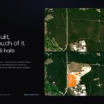
Over a 51.6 km² window at Grünheide in Brandenburg, comparing July 2019 with August 2024: 45 hectares of new built surface, in 5 structures over 2 hectares each.
Request access at zephyr-space.com
#Construction #EarthObservation #Sentinel2 #Infrastructure #Insurance #Geospatial #Germany

11
If your work is non-profit or conservation, Zephyr is free. Not a trial, not a watermarked export, not a cut-down tier — the same engine, the same run record, the same files out.
Who that covers: conservation NGOs, protected-area and park authorities, ranger teams, academic monitoring programmes, and public-interest investigations.
The reason is not charity. It is that the people with the sharpest questions in Earth observation are usually the ones with no budget for it.
The card shows Lake Urmia in north-western Iran — a Ramsar site, a UNESCO Biosphere Reserve, and until recently one of the largest saline lakes on Earth. Across a 1,963 km² window: water surface 1,366 km² in July 2019, 540 km² in July 2025. A loss of 820 km², down 60%. Violet is lakebed that was under water six years ago.
That window is a section of the lake, not the whole of it, and the distinction matters — Iran's own environmental authority put the entire lake at roughly 581 km² in summer 2025, down from about 2 billion cubic metres of water in 2024 to half a billion. What is left behind is salt, and the public-health concern is airborne salt reaching the millions of people living around the basin.
None of that analysis is hard. It is two scenes, one index, a season match and about two minutes of compute. It should not be a procurement exercise for the people trying to document it.
What you get is the full chain: ask in plain language, get a georeferenced result, export GeoJSON or GeoTIFF, pin it as a monitor that re-runs on every pass. What we ask is that you tell us the question you are trying to answer.
Get in touch — zephyr-space.com
#Conservation #EarthObservation #RemoteSensing #Sentinel2 #WaterSecurity #OpenData

When a wildfire is declared out, the emergency moves downhill.
Fire at high severity does not only remove the trees. It bakes the soil into a water-repellent crust and burns away the roots and litter that used to hold it together. The first heavy autumn rain then runs straight off instead of soaking in — and a catchment that used to absorb a storm delivers it, all at once, to whatever sits below: a road, a culvert, a village.
So the operational question after a fire is not only how much burned. It is also which ground burned hard enough to stop absorbing water, and what lies downslope of it.
This is Robledo de Chavela, west of Madrid. Of a 597 km² window, 15.2 km² burned at high severity. That is the ground that matters for the months that follow: where to stabilise slopes, which culverts to clear, which valleys to warn, and where replanting will not take without help.
The figure is deliberately tight. Thresholding the burn ratio alone would also have counted farmland that simply dried out between June and September, which looks identical to fire in that index. Requiring a genuinely charred surface as well removes it. That precision is not pedantry — an inflated burn map sends a finite remediation budget to slopes that never needed it, and leaves the ones that did.
Zephyr can make useful the information that you and your community need most for your planning, emergency response and prevention.
Zephyr is in early access — request access at zephyr-space.com
#EarthObservation #RemoteSensing #Sentinel2 #Wildfire #PostFireRecovery #DebrisFlow #CivilProtection #Geospatial

People hear "on-chain" and picture the data going on-chain. It does not, and it should not — a flood mask is megabytes and nobody wants to pay to store it on a ledger, or to publish a customer's concession boundaries to the world.
What goes on-chain is a fingerprint.
The run finishes. The scene identifiers, the operator chain, the model version and the result are folded into one digest. The digest is committed. Anyone can read it back.
The card shows the fields for a real run: the Sindh floodplain, Sentinel-2 scenes S2A_42RVQ_20220513 and S2A_42RVQ_20220910, chain fetch → ndwi → change → clean → measure, result new flood across 9.68% of the frame. Keep the artefact and you can recompute the digest and see it match. Change one pixel, one threshold, one scene, and it does not.
This is the useful property, and it is a modest one stated plainly: nobody has to trust the storage. Not us, not our host, not the customer's own IT department. The artefact either hashes to the committed digest or it does not, and that check is arithmetic rather than a conversation.
The read is public. No account, no API key, no permission from us — that is not a feature we are proud of, it is the entire point. An integrity guarantee you have to ask us for is not an integrity guarantee. Verify, don't trust.
zephyr-space.com
#DataIntegrity #Provenance #EarthObservation #RemoteSensing #Reproducibility #Sentinel2 @FlareNetworks

21
Illegal gold mining does not hide well from orbit, and it does not need a before-image to find.
La Pampa, Madre de Dios. Alluvial mining does two things rainforest never does: it strips the canopy to bright bare river sediment, and it leaves pools of turbid, sediment-loaded water. Bare ground is brilliant across the visible bands with almost no vegetation signal; the ponds reflect more green than near-infrared, the inverse of anything alive. Two tests, one scene.
That matters operationally. Change detection needs a clean, season-matched baseline, and in the western Amazon you can wait months for two comparable cloud-free scenes. A single-scene signature runs on whatever came down this week.
MAAP records 28,292 hectares cleared by mining in the southern Peruvian Amazon between 2021 and 2023, and 2,554 more in the first quarter of 2024 alone. Almost all of Peru's mining deforestation is concentrated in this one region.
What imagery cannot tell you is which of these workings holds a licence. That needs the mineral-rights register. Detection narrows the search; the paperwork decides who to act on. We can compute both.
Zephyr is in early access — request access at zephyr-space.com
#EarthObservation #RemoteSensing #Sentinel2 #IllegalMining #Amazon #Peru #ResponsibleSourcing #ESG

20
The Evros fire of August 2023 was sadly one of the largest wildfire ever recorded in the European Union. It burned for 17 days through the Dadia–Lefkimi–Soufli forest, one of the most important protected areas in Europe for raptors.
Perimeter maps were published within days. Perimeter is the easy part, and it is not what recovery planning needs.
Measured over a 1,979 km² window, comparing 3 August with 12 September: 161.9 km² — 16,194 hectares — burned at high severity. A further 2.2% of the frame falls in the moderate class, which is computed and deliberately not shown on the card.
That omission is the point of the post. The standard burn index, dNBR, drops sharply between an early-August scene and a September one across whole landscapes that never saw fire, simply because the vegetation dried out. Publish dNBR alone across a Mediterranean summer and you will report a burn scar the size of a county that does not exist. So a second test is applied: the ground has to be genuinely charred in the shortwave infrared, not merely less green than it was. Only the class that passes both is drawn.
High severity is the operational number. It is where canopy is gone rather than scorched, where soil is hydrophobic, where the debris-flow risk sits in the first rains, and where natural regeneration will not happen on its own. Those are different interventions from a light burn, and they need to be mapped separately or the money goes to the wrong hillsides.
Request access at zephyr-space.com
#Wildfire #EarthObservation #Sentinel2 #Greece #Forestry #DisasterResponse #Resilience

23
Every EO vendor keeps an audit trail. They also control it.
So we stopped asking to be believed. Each run folds its scenes, chain, model version and result into one digest, committed where we can't reach it.
Integrity, not correctness. Different claims.
zephyr-space.com
#EarthObservation #DataIntegrity #Provenance #Auditability #RemoteSensing #Geospatial #FlareNetwork @FlareNetworks

8
Radar does not care whether the transponder is switched on.
This is Sentinel-1 synthetic aperture radar over the Singapore anchorage. Water is radar-dark; a steel hull is a bright point target. Every ring is a detection — no optical imagery, no daylight, no cloud-free pass required.
On its own that is a vessel count. Crossed against AIS, it becomes something else: the ships present in the water and absent from the record. That gap is where fisheries enforcement, sanctions monitoring and port-state control all begin.
Two honest limits. A radar detection tells you a vessel is there, not what it is or who owns it — identity needs AIS, registry data or higher-resolution imagery. And Sentinel-1's revisit means a snapshot every few days, not a live track; matching a detection to an AIS position is only meaningful when the two are close in time.
Within those limits it is the most reliable wide-area maritime picture available from open data, and it costs the same whether you watch one anchorage or an entire EEZ.
Zephyr is in early access — request access at zephyr-space.com
#EarthObservation #SAR #Sentinel1 #MaritimeSecurity #IllegalFishing #AIS #Geospatial #OpenData

Storm Daniel put Greece's main agricultural belt under water in September 2023. Copernicus rapid mapping put the flooded area near 73,000 hectares.
This is the Karditsa plain, before and after. Red is water present in September and absent in the July scene — 16.97% of the frame.
Look at the shape of it. The flood front follows field boundaries, irrigation channels and the drainage network; it is not a smooth lobe. That texture is the whole value of a 10-metre mask over a headline figure: it tells a loss adjuster which parcels, an agronomist which crops, and a civil-protection officer which roads are cut.
Thessaly produces a significant share of Greece's agricultural output. Cotton, maize and orchards were still standing when this image was taken. The difference between "the plain flooded" and "these 4,000 parcels flooded, here" is the difference between a news story and a payment.
Zephyr is in early access — request access at zephyr-space.com
#EarthObservation #RemoteSensing #Sentinel2 #FloodMapping #Greece #Agriculture #Insurance #Geospatial

Lake Powell is near its record low. The gauge says so; we wanted an independent reading, so we measured the water surface instead.
A 315 km² section above Page: 41.5 km² of water in August 2023, 31.4 km² in August 2026. A net fall of 24%. Violet is the 11.2 km² that was wet and is now dry.
Three deliberate choices, each of which would break the result if dropped.
August 2023 followed an exceptional snowpack that lifted Powell about 65 feet that summer, so the baseline is a local high. The fall is real and the comparison is fair, but the starting point flatters it.
Zephyr is in early access — request access at zephyr-space.com
#EarthObservation #RemoteSensing #Sentinel2 #ColoradoRiver #Drought #WaterManagement #Geospatial

2
36
In the summer of 2022 the Po ran lower than it had in living memory. Here is the number instead of the adjective.
Water surface near Casalmaggiore: 7.1 km² in August 2021, 5.4 km² in July 2022. Violet is riverbed that was under water and is exposed.
Same window, same sensor, same season.
What makes this operationally interesting is not the drought, which everyone could see. It is that the measurement is repeatable on a schedule. The same chain run every pass turns a one-off headline into a monitored quantity: abstraction licensing, hydropower planning, irrigation allocation and inland navigation all need the trend rather than the anecdote.
The Po basin supplies a large share of Italian agriculture and hydroelectric generation. Measuring it from orbit costs the same whether you do it once or every ten days.
Zephyr is in early access — request access at zephyr-space.com
#EarthObservation #RemoteSensing #Sentinel2 #Drought #WaterSecurity #Italy #Agriculture #ClimateRisk

1
37
When the Kakhovka dam failed on 6 June 2023, a reservoir roughly the size of the Great Salt Lake drained in under a week.
This is a 50 km stretch of it. Water surface in the frame: 173.6 km² in May, 14.6 km² by July. Violet is bed that held water and became dry rock — 91.4% of the surface in this window. The blue thread is the Dnipro channel, which the reservoir had drowned since 1956 and which reappeared within days.
Anyone with the scene identifiers can recompute this and get the same answer, which is the difference between a finding and an illustration.
Zephyr is in early access — request access at zephyr-space.com
#EarthObservation #RemoteSensing #Sentinel2 #Ukraine #WaterSecurity #Geospatial #DisasterResponse #OpenData

1
30