

Making use of advanced space & geospatial tech to model future scenarios & provide info that can improve efficiencies, reduce risk & inform better decisions.
- Tweets175
- Following25
- Followers34
- Likes113

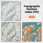



ALT Graphic titled "Topographic Position Index (TPI)", featuring three topographic map panels against a pale, textured terrain background. The upper-left and lower-left panels show a detailed landscape with subtle elevation shading in white, grey, teal and orange. The lower-right panel presents a more pronounced TPI classification of the same terrain, with teal representing areas below the surrounding average elevation and orange representing areas above it. Each map includes a north arrow and a scale bar. An orange button labelled "Article" appears beneath the title.


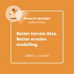
ALT Square orange graphic with a white rounded rectangular border. At the top, a circular illustration depicts a desk lamp in brown and orange tones. Beside it, the heading reads “Research Spotlight” in bold white text, with “Gully Erosion” underneath. The main message, in large, bold white lettering, reads: “Better terrain data. Better erosion modelling.” At the bottom, white text reads “DEMSA | 2 m DEM”. The design uses a consistent orange, white and brown colour palette.

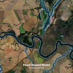
ALT A satellite image overlaid with blue and green flood hazard zones along a winding river, showing surrounding agricultural land, vegetation and a road. The image is labelled “Flood Hazard Model – working example”.

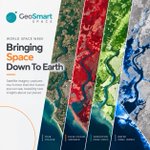
ALT A GeoSmart Space graphic for World Space Week titled “Bringing Space Down To Earth.” The image shows four vertical satellite-image views of the same coastal landscape and winding river, demonstrating different ways of interpreting Earth observation data: True Colour, False Colour Infrared, Vegetation Index (NDVI) and Water Index (NDWI). The images use progressively different colour schemes to highlight vegetation, water and other landscape features. Text explains that satellite imagery captures much more than the human eye can see, revealing new insights about our planet. The GeoSmart Space logo appears at the upper left.


ALT The infographic is titled “Viewshed and Line-of-Sight Analysis Over a High-Resolution Digital Surface Model.” It shows a telecommunications mast on elevated terrain, with lines radiating to surrounding areas to illustrate visibility. Green areas are visible, while orange areas are not visible because of vegetation, terrain, or urban features. A 20 km search radius is indicated. Panels on the left show key applications: telecommunications masts, renewable energy such as wind turbines, wireless internet and IoT coverage, and environmental impact studies. Panels on the right show custom deliverables, including visibility rasters, line-of-sight networks, and comprehensive PDF maps. The GeoSmart logo appears at the bottom right.


ALT Infographic titled “Ground Truthing” explaining why validating elevation data is important. On the left, illustrated icons accompany benefits: validating the vertical accuracy of elevation datasets, confirming products meet performance standards, quantifying uncertainty with recognised statistical measures, identifying and correcting systematic elevation bias, increasing confidence for applications like hydrology, engineering, agriculture, mining, and environmental studies, and ensuring decisions are based on data that accurately reflects real-world conditions. On the right, three illustrated panels show the workflow: (1) collecting survey-grade GNSS ground control points in the field, (2) extracting and comparing DEM elevations with surveyed locations on a 3D terrain model, and (3) assessing accuracy using statistical measures including MAE, standard deviation, and the 90th percentile error (P90). The design uses GeoSmart’s teal and orange colour palette on a light background.

ALT A square social media graphic titled "Where Water Goes" explores how terrain influences vegetation water use across the Western Cape, South Africa. The upper half features a detailed map of the province overlaid on a satellite image. The landscape is colour-coded using a terrain classification legend, with pale turquoise representing flat plains, greens indicating tablelands and plains with increasing relief, yellows and oranges showing plains with hills, reds and browns representing open hills and mountains, and shades of grey marking low to high mountain ranges. The mountainous Cape Fold Belt stands out prominently in grey across the southern part of the province. A north arrow appears in the lower-left corner of the map, while a scale bar from 0 to 200 km is shown in the lower-right. The bottom section has a dark teal background with the large white title, the subtitle "How terrain shapes vegetation water use in the Western Cape", and a rounded white rectangle labelled "Article".


ALT The image shows a stylised map interface with streets, buildings, and place names in a light grey background. Several coloured circular markers—orange, pink, and teal—are scattered across the map, suggesting data points or areas of activity. Below the map, a large orange panel contains bold white text reading “Web map service,” followed by “noun phrase.” Beneath this, a definition explains that it is “a way to view maps online by requesting images from a server, rather than downloading the underlying data itself.” The overall design is clean and modern, resembling an educational or social media graphic about GIS concepts.

ALT A colourful digital elevation model (DEM) map showing rugged mountainous terrain with varying heights represented in green, yellow, orange, red, and white. A white text box overlays the image with the title “SUDEM+” and the subtitle “A New Standard for Accurate and Reliable Elevation Data,” alongside a small label reading “Article.”