




Jack_Dev retweeted

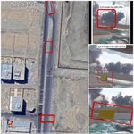
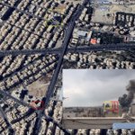
Israeli airstrike near Khan Younis, Gaza.
31.340149, 34.310288
@GeoConfirmed #Gaza


Three Palestinian terror operatives who emerged from a tunnel in southern Gaza's Khan Younis yesterday were targeted in an airstrike, the military says.
The IDF says the tunnel shaft was located on the western, Hamas-side, of the "Yellow Line."
After troops identified the trio emerging from the tunnel, an airstrike was carried out against the shaft and the operatives, the military says, adding that secondary explosions were seen, indicating the presence of explosives in the tunnel.
Jack_Dev retweeted

Geolocation| Yellow block placed by Israeli forces amid destruction near the destroyed Shujaiya Park, now turned IDP Camp, Gaza City, Northern #Gaza.
Approx. 400m west of the formal yellow line
31.501853, 34.467644
🗓️Night of 10-11 Oct. 2026
@GeoConfirmed
teapawt.net/qudsn/status/210918673…


Jack_Dev retweeted
Geolocation| Crater and destruction, including multiple tents after an Israeli airstrike on the Al-Gharabli building, on Omar Al-Mukhtar Street, Gaza City, Northern #Gaza
A warning was reportedly given
31.502432, 34.465589
🗓️Night of 8-9 Oct. 2026
teapawt.net/F24online/status/21085…


Jack_Dev retweeted
Geolocation| The destroyed Martyrs Monument at the Birzeit University after it was reportedly taken away by Israeli forces in Birzeit, Ramallah and Al-Bireh Governorate, occupied #WestBank
31.958740, 35.181575
🗓️Early morning of 5 Oct. 2026
@GeoConfirmed
teapawt.net/qudsn/status/210698234…


Jack_Dev retweeted
Geolocation| Small UAV, likely operated by Israeli forces, flying above Palestinians walking in the street, next to the heavily damaged Yemen Al-Saeed Hospital, Jabalia Camp, North #Gaza
31.536143, 34.496016
🗓️15 Sep. 2026
@GeoConfirmed

Jack_Dev retweeted
What appears to be a Elbit Hermes 900 UAV flying over the Tel Al-Hawa neighborhood of Gaza City, as captured on 3 April 2024 Google Earth imagery.
31.503870, 34.438534
@GeoConfirmed

Jack_Dev retweeted

Additional confirmation of the location of the house that was the target:


(Possibly) The house from which locals claim the senior official was kidnapped.
01/09/2026
31.5177076, 34.4378787
8G3PGC9Q+35J6FQ7
@GeoConfirmed @viditbot

Jack_Dev retweeted

Geolocation of an Israeli Strike on a reported Qassam [Hamas] Weapons production site.
Location: 31.431650, 34.381523
8G3PC9JJ+MJ Al Zawayda, Deir Al Balah Governorate, Gaza Strip.
@GeoConfirmed

The Israeli Air Force bombed a Hamas weapon production site in the central Gaza Strip and killed a commander in the terror group in separate strikes today, the military announces.
A strike in the Maghazi camp killed Ismail Abu Ful, who the military says was the commander of an arms production site.
The IDF says "the terrorist took an active part in manufacturing explosive devices and anti-tank rockets" for Hamas, and he was "eliminated to remove the threat."
In a separate strike in the nearby town of az-Zawayda, the IAF struck a weapons manufacturing site "near an aid distribution point operated by an international organization," according to the IDF.
Shrapnel from that strike, which came after a warning by the IDF for residents of the area, reportedly killed a four-year-old boy and injured six others.
"This is another example of Hamas’s systematic use of and embedding within civilian infrastructure, including aid distribution centers, to advance and execute terror attacks against IDF troops operating in the Yellow Line area and against Israeli civilians," the military says.
The IDF says the arms production site shows that Hamas "systematically violates the ceasefire agreement while attempting to rehabilitate its military capabilities and strengthen its force buildup."

Footage blowing up village Bani Hayyan southern Lebanon 33.242154, 35.496483 @GeoConfirmed


This quoted post is unavailable.
Jack_Dev retweeted

A new video shows the destruction of the Azadi Sports Hall, a 12,000-seat sports arena in west Tehran, nearly six months after it was bombed in the early days of the US/Israel war with Iran.
Location: 35.722083, 51.269058
@GeoConfirmed

THREAD: Verified videos of the Iran/US/Israel war - 5 March
The 12,000-seat Azadi Sports Hall, part of the Azadi Sports Complex in west Tehran, was the target of an air strike this morning. The stadium was severely damaged.
Location: 35.722083, 51.269058
@GeoConfirmed
Jack_Dev retweeted
In the night of 21-22 July, Israeli forces seemingly placed another yellow block at Salah Al-Din Street, south of the Dawla roundabout in the Al-Zeytoun neighborhood of Gaza City, Northern #Gaza
31.490505, 34.452431
370m west of the official yellow line.
teapawt.net/NemoAnno/status/207926…
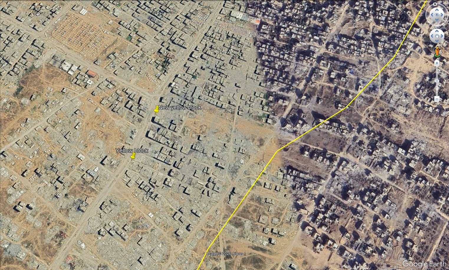

Geolocation| Yellow block and vehicle tracks on Salah Al-Din Street, south of the Dawla Junction in the Zeytoun neighborhood, Gaza City, Northern #Gaza
31.489306, 34.451556
🗓️16 July 2026
More than 300 meters NW of the official yellow line.
@GeoConfirmed
teapawt.net/nowgnna/status/2077462…


Jack_Dev retweeted
GeoConfirmed announcement.
Following the ill-advised decision to discontinue support for the Google Earth desktop application and to redirect users to the less functional online version, we are witnessing yet another misstep by Google with far-reaching consequences.
The fight against engagement farmers, disinformation campaigns, and adversarial actors seeking to influence public discourse is already an immense challenge. Satellite imagery has long served as a critical benchmark in countering disinformation and verifying claims, and Google Earth was one of the most important tools in this effort.
It is with great concern that we are already observing individuals exploiting the new Google Earth web tool to make military positions, relabel buildings as schools,... and experiment with manipulating the information environment. In effect, users can now fabricate or alter satellite-derived visuals to support false narratives.
The primary, and perhaps only, practical use of this tool appears to be the creation and dissemination of mis- and disinformation. Users can fabricate scenes or objects that do not exist, or alter real locations to depict false realities, and then distribute these manipulated visuals online as if they were authentic.
Fact-checkers may soon find themselves verifying Google satellite imagery using...Google satellite imagery, rather than fact-checking the original claims.
As some experienced geolocators have noted: “We just realized that geolocators are going to have to waste time geolocating fake Google Earth images now to debunk disinformation. This is fucking chaos.”
We urge @Google to reconsider this decision.
@googleearth should aid the global effort against dis- and misinformation, not inadvertently enable it.
Do not become like X.

Today we’re bringing AI image generation with Nano Banana to Google Earth, letting you virtually reimagine anywhere in the real world. 🍌 goo.gle/44SUsOP
For the first time, you can generate custom images using Google Earth’s satellite, aerial, and 3D imagery. 🌎
Jack_Dev retweeted
Newly published CCTV footage shows the moment the Shajareh Tayebeh primary school and a nearby IRGC compound in Minab, Iran, were targeted by Tomahawk missiles on 28 February, killing 120 children.
CCTV: 27.101690, 57.080159
Minab school: 27.109804, 57.084732
@GeoConfirmed
Jack_Dev retweeted

Geolocation #368: Dar Al Al-Muttaqin Mosque Bombed and Destroyed in Gaza City
غارة اسرائيلية تدمر مسجد دار المتقين بجانب ملعب/مخيم اليرموك في مدينة غزة
🗓️July 28, 2026
Next to Al Yarmouk Stadium/IDP, Al Daraj quarter, Gaza city, Palestine
📍31.516650, 34.456481


Jack_Dev retweeted
Columns of smoke rise from a naval base and university owned by Iran's Islamic Revolutionary Guard Corps (IRGC) in the northern town of Zibakenar on the shores of the Caspian Sea following US strikes.
Location: 37.441677, 49.864212
@GeoConfirmed
Jack_Dev retweeted

Israeli one-way attack drone/missile remnants displayed by Civil Defence spokesperson Mahmoud Basal after a strike that killed Firas Ahmed al-Masri, his wife, and four children in Gaza City.


Jack_Dev retweeted
Geolocation| Yellow block and vehicle tracks on Salah Al-Din Street, south of the Dawla Junction in the Zeytoun neighborhood, Gaza City, Northern #Gaza
31.489306, 34.451556
🗓️16 July 2026
More than 300 meters NW of the official yellow line.
@GeoConfirmed
teapawt.net/nowgnna/status/2077462…

Jack_Dev retweeted
Geolocation #364: Airstrike on an Apartment in Gaza City Kills a Family of Five, Including 3 Children
غارة على شقة في حي الرمال بمدينة غزة تقتل أسرة من 5 أفراد بينهم 3 أطفال
🗓️July 18, 2026
Lababidi roundabout, Al Rimal Quarter, Gaza city, Palestine
📍31.529036, 34.452669


Jack_Dev retweeted
Geolocation #363: Strike on Funeral Kills 9 Palestinians in Al Nuseirat
استهداف جنازة في النصيرات يقتل 9 فلسطينيين
🗓️July 17, 2026
Al Nuseirat, Central Gaza, Palestine
📍31.447181, 34.385747

Jack_Dev retweeted
🧵Geolocations of 2 yellow blocks, likely placed by the Israeli military, roughly 330 & 380 meters northwest of the formal yellow line in the Shuja'iyya neighborhood, Gaza City, Northern #Gaza
This is SW from 2 other blocks placed in mid June 2026.
teapawt.net/NemoAnno/status/206665…

Geolocation| 2 yellow blocks, reportedly placed by Israeli forces, at the Sanafur Junction in the Al-Tuffah neighborhood of Gaza City, Northern #Gaza
31.506660, 34.471156
🗓️15 June 2026
@GeoConfirmed
teapawt.net/Sa7atPl/status/2066431…
