

News/Talk KRMS, The Voice of the Lake of the Ozarks. 1150am, 97.5fm & 103.3fm
- Tweets55.7K
- Following271
- Followers1.4K
- Likes138









ALT This graphic displays a severe thunderstorm warning plotted on a map. The warning is in effect until 2:15 AM CDT. The warning includes Eldon MO, Versailles MO and Stover MO. This warning is for Northwestern Miller County in central Missouri and Morgan County in central Missouri. The threats associated with this warning are wind gusts up to 60 MPH and pea sized hail. There are 26,861 people in the warning along with 15 schools and 0 hospitals.

ALT This graphic displays a severe thunderstorm warning plotted on a map. The warning is in effect until 2:15 AM CDT. The warning includes Eldon MO, Versailles MO and Tuscumbia MO. This warning is for Northwestern Miller and Eastern Morgan Counties. The threats associated with this warning are wind gusts up to 60 MPH and pea sized hail. There are 21,075 people in the warning along with 12 schools and 0 hospitals.

ALT This graphic displays a severe thunderstorm warning plotted on a map. The warning is in effect until 2:15 AM CDT. The warning includes Eldon MO, Tuscumbia MO and Barnett MO. This warning is for Northwestern Miller and Southeastern Morgan Counties. The threats associated with this warning are wind gusts up to 60 MPH and nickel sized hail. There are 14,330 people in the warning along with 8 schools and 0 hospitals.


ALT This graphic displays a severe thunderstorm warning plotted on a map. The warning is in effect until 2:30 AM CDT. The warning includes Wardsville MO, Russellville MO and Saint Thomas MO. This warning is for Southern Moniteau County. The threats associated with this warning are wind gusts up to 60 MPH and pea sized hail. There are 8,345 people in the warning along with 8 schools and 0 hospitals.

ALT This graphic displays a severe thunderstorm warning plotted on a map. The warning is in effect until 2:45 AM CDT. The warning includes Rolla MO, Dixon MO and Belle MO. This warning is for Maries County in central Missouri, Miller County in central Missouri, Northern Pulaski County in central Missouri, Northwestern Phelps County in east central Missouri and East central Camden County in central Missouri. The threats associated with this warning are wind gusts up to 60 MPH and nickel sized hail. There are 58,945 people in the warning along with 26 schools and 1 hospital.

ALT This graphic displays a severe thunderstorm warning plotted on a map. The warning is in effect until 2:15 AM CDT. The warning includes Eldon MO, Tuscumbia MO and Olean MO. This warning is for Southeastern Morgan County Is Cancelled. The threats associated with this warning are wind gusts up to 60 MPH and nickel sized hail. There are 9,731 people in the warning along with 8 schools and 0 hospitals.

ALT A Tornado Watch has been issued for areas east of Highway 65 until 11 PM this evening. While the primary hazards with any strong storm will be damaging wind gusts up to 60-70 mph, quarter-sized hail and a couple tornadoes are also possible. Have multiple ways to receive warnings!

ALT This graphic displays a severe thunderstorm warning plotted on a map. The warning is in effect until 11:45 PM CDT. The warning includes Bolivar MO, Buffalo MO and Pleasant Hope MO. This warning is for Southwestern Dallas County in southwestern Missouri, Southeastern Cedar County in southwestern Missouri, Polk County in southwestern Missouri and Northeastern Dade County in southwestern Missouri. The threats associated with this warning are wind gusts up to 60 MPH and penny sized hail. There are 37,617 people in the warning along with 21 schools and 1 hospital.

ALT This graphic displays a special weather statement plotted on a map. The statement is in effect until 9:45 AM CDT. The statement includes Rolla MO, Saint James MO and Doolittle MO. STRONG THUNDERSTORMS WILL IMPACT SOUTHEASTERN MARIES AND PHELPS COUNTIES THROUGH 945 AM CDT. The threats associated with this storm are wind gusts up to 55 MPH and penny sized hail. Seek shelter in a sturdy structure until the storm passes.

ALT This graphic displays a flash flood warning plotted on a map. The warning is in effect until 10:00 AM CDT. The warning includes Rolla MO, Saint James MO and Northwye MO. This warning is for Southeastern Maries County in central Missouri and Northern Phelps County in east central Missouri. Avoid walking or driving through flood waters! Move immediately to higher ground! There are 41,335 people in the warning along with 12 schools and 1 hospital.

ALT This graphic displays a special weather statement plotted on a map. The statement is in effect until 9:30 AM CDT. The statement includes Waynesville MO, Saint Robert MO and Dixon MO. The threats associated with this storm are wind gusts up to 55 MPH and penny sized hail. Seek shelter in a sturdy structure until the storm passes.

ALT This graphic displays a severe thunderstorm warning plotted on a map. The warning is in effect until 8:45 AM CDT. The warning includes Eldon MO, Osage Beach MO and Village of Four Seasons MO. This warning is for Western Maries County in central Missouri, Miller County in central Missouri, North central Camden County in central Missouri and Southeastern Morgan County in central Missouri. The threats associated with this warning are wind gusts up to 60 MPH and pea sized hail. There are 40,034 people in the warning along with 17 schools and 0 hospitals.
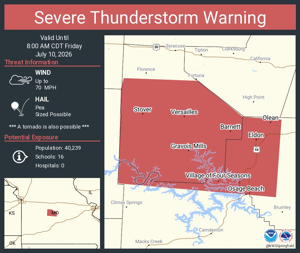
ALT This graphic displays a severe thunderstorm warning plotted on a map. The warning is in effect until 8:00 AM CDT. The warning includes Eldon MO, Osage Beach MO and Versailles MO. This warning is for Northeastern Benton County Is Cancelled. The threats associated with this warning are wind gusts up to 70 MPH and pea sized hail. There are 40,239 people in the warning along with 16 schools and 0 hospitals.