
senior scientist, PhD 2000 meteorology & oceanography (Utrecht Univ., NL). WMO O3/UV SAG, AGU, EGU, EUMETSAT roadmap AI/ML, WMO expert team nowcasting Africa
tweets and opinions are always personal …
Joined July 2010
- Tweets6.3K
- Following119
- Followers590
- Likes1.4K




Pinned Tweet
This expanding list of essays discussing emerging problems with science and scientific research will serve as a pinned tweet for a long time.
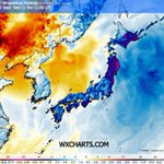
het was koud in Japan de afgelopen dagen.


🥶Early #cold records in #Hokkaido, Japan (11 Nov 2026):
Asahikawa: 🌡️−12.5°C — earliest ≤−12°C reading by 11 Nov in ~120 years (−13.0°C on 11 Nov 1906).
Horokanai: 🌡️−20.2°C — Japan’s earliest sub−20°C reading, breaking the 1988 record. Diamond dust observed.


34

dr. Jos PhD retweeted

I'm seeing increased organization of science academies to push government on issues.
I do not expect it to end well.
If the academies act like just another advocacy network they will deepen public distrust in science and lose government support.
nasonline.org/news/s20-press…

EUMETSAT MTG kleurencomposiet satellietbeeld van nachtelijke mist (gifgroen, 3-6 UTC; alleen bruikbaar 's nachts). Een dunne mistlaag: de Veluwe en Heuvelrug steken er bovenuit. De paarse plekken zijn thermische anomalien van industriele warmtebronnen (quiz: welke zijn te zien?).
1
95
dr. Jos PhD retweeted

Image of the Week: MTG-I2 in action! 🛰️
Last week we revealed the 1st visuals from MTG-I2 just over 2 months after launch.
Captured on 3-4 Nov this video shows convective clouds building over the NW Sahara, transitioning from true-colour to high-res visible & infrared imagery🧵
The 2026 Antarctic stratospheric vortex was stable and cold. Favorable for lots of ozone destruction but that did not materialize. Late to start, by the end of September it ran out of time for a deep ozone hole. The reason: much less ozone depleting substances than 25 years ago.

2
45
Bakken aan regen verwacht in vrijwel alle Europese regio's grenzend aan de Middellandse Zee de komende twee weken.

2
64
dr. Jos PhD retweeted

Before the Moho, there was the bora rotor 🌀
Andrija Mohorovičić is famous for discovering the crust–mantle boundary (1910).
Less known: about twenty years earlier, as a professor at the Royal Nautical School in Bakar, he published what appears to be the first drawing of a complete atmospheric rotor, including the reversed flow at the surface. It was in the bora (bura).
On 18 October 1888, during bora, he saw a large cumulus sitting still over Bakar Bay while clouds above it raced away in strong northeasterly flow. New cloudlets kept forming on one edge and fragments evaporated on the other, which meant rising air on one side and sinking air on the other. Surface winds over Rijeka Bay blew back against the bora. His conclusion was that the air was rotating about a horizontal axis.
The note appeared in Meteorologische Zeitschrift in 1889, with commentary by editor Julius von Hann, and was translated into English the same year. Hann, Wegener and Küttner all cited it.
Then the diagram, printed in a separate appendix, was forgotten until it was rediscovered in 2005.
Twenty years later Mohorovičić used the same approach, careful observation followed by physical reasoning, and found the Moho.
📄 Grubišić, V. & Orlić, M. (2007): Early observations of rotor clouds by Andrija Mohorovičić. Bull. Amer. Meteor. Soc., 88(5), 693–700. doi.org/10.1175/BAMS-88-5-69…
Animation: GPT6 Astra
#bura #bora #Mohorovičić #meteorology #HistoryOfScience
dr. Jos PhD retweeted

More data from the SMILE mission have just been released. Here are the images reprocessed into a polar projection. A stunning substorm progression can be seen with multiple onests spreading east, west, and poleward. These views are incredible!
dr. Jos PhD retweeted

A moment of silence for the NAM forecast model which is retiring tomorrow morning after 20 years.
dr. Jos PhD retweeted

Ik roep het al een tijdje. Nu concludeert de overheid het zelf ook: het overgrote deel (80%) van de 'klimaatwinst' door reductie van CO2-emissie in de NL industrie sinds 2021 is gevolg van productiedaling en is dus feitelijk slechts verplaatsing van emissies.
#grafiekvandedag

dr. Jos PhD retweeted

The jaw-dropping Sentinel-2 satellite pass of 190 MPH Hurricane Melissa, on this day in 2025.

dr. Jos PhD retweeted

A year ago I made this wild animation of Hurricane Melissa.
It broke my brain a little.
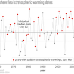
Er is wat "gedoe" over een mogelijk op hande zijnde verstoring van de polaire stratosferisch vortex en verzwakking van westenwinden (correct) en het opbreken ervan (incorrect). Het gaat primair om een verschuiving en een mogelijke tijdelijke splitsing ...
1
101


dr. Jos PhD retweeted
Ongewenste waarheid?
RIVM berekent over de periode 2010-2019 in NL een oversterfte van circa 12000 mensen per jaar door kou*.
Energiearmoede lijkt een belangrijke rol te spelen.
#grafiekvandedag
*en 350 per jaar door hitte.

dr. Jos PhD retweeted

Zeer relevant nieuws weer. 📢
Rampscenario👇 stijging zeespiegel IPCC gaat uit v kettingreactie bij instorten gletsjers Antarctica.
MAAR: studie 1.500 gletsjers, kettingreactie NIET TE ZIEN. 😳
Dusss: extreemste zeespiegelstijging van de baan. 🥳
news.mit.edu/2026/satellite-…

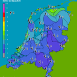
Windrichting en stroming over het IJsselmeer precies goed voor een lange "fetch" tussen Enhuizen en Stavoren waardoor er een buienrijtje ontstaat richting de stad Utrecht?


61
