Official Observer for The Weather Network. Weather fanatic, Bowling fanatic, Three Stooges fanatic. I am a victim of circumstance...

Windsor,Ontario
Joined October 2009
Tony Annyschyn retweeted
HAZMAT: Raw video of the hazmat situation in Toledo, OH. The chemical has been identified as glycidyl methacrylate from a 5,500 gallon tank. A mandatory 1 mile evacuation radius and 3 mile shelter in place order remains in effect!
34
145
33
513
152,256
Tony Annyschyn retweeted
A Frost Advisory is in effect for parts of Southeast Michigan tonight. Frost could harm temperature sensitive vegetation. Take steps now to protect tender plants from the cold. #miwx
11
23
2,507
Tony Annyschyn retweeted
A Freeze Warning and Frost Advisory are in effect for Southeast Michigan tonight. Frost and freeze conditions could kill crops and other sensitive vegetation. Take steps now to protect tender plants from the cold. #miwx
15
1
47
4,977
Tony Annyschyn retweeted
Significant Weather Outlook for Friday 👇 Wind gusts of 70-80km/hr possible across parts of Southern #Ontario with the strongest gusts being near Lake #Huron #OnWX #ONStorm
5
9
1
49
6,662
Tony Annyschyn retweeted
This is LATE for a last 30C in Windsor, Ont. I hope you didn't close the pool! @weathernetwork
3
2
2
21
853
Tony Annyschyn retweeted
Hot spot across Canada this hour is #Windsor...sitting at a balmy 29.2°C with a humidex of 36 🥵 #OnWX #ONStorm
3
7
2
38
4,872
Tony Annyschyn retweeted
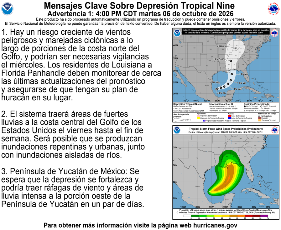
Tropical Depression Nine has formed in the Gulf! It's forecasted to strengthen into a Hurricane by Friday then track northward towards Southern #Ontario Great uncertainty remains if we'll see any impacts and by then it will just be the remnants of the weakening storm At this point it may reach us by Sunday PM but only the 🇪🇺 model is most bullish bringing the swath of rain into the region with the north shores of Lk #Erie and Ontario seeing the heaviest rainfall Both 🇺🇸 and 🇨🇦 models have little to no impacts Will monitor and update! #OnWX #ONStorm
4 PM CDT Tue Oct 6 (Advisory 1) Key Messages for Tropical Depression #Nine. Latest info: hurricanes.gov 4 PM CDT martes 6 de octubre (Aviso 1) Mensajes clave sobre la depresión tropical #Nueve. Más información: hurricanes.gov
4
13
1
53
10,405
Tony Annyschyn retweeted
The @westernuNTP team is confirming an additional Tornado in Deep SW #Ontario from the storms that went through on September 3rd 2026 An EF0 tornado occured South of #Windsor in River Canard Max wind speed of 125km/hr with a length of 5km and width of 200m #OnWX #ONStorm
1
6
1,916
Tony Annyschyn retweeted
Fall officially begins Tuesday evening, but it already feels like it today and will for the rest of the week. Expect highs in the 60s with a cool breeze and grey skies.
1
1
6
670
Tony Annyschyn retweeted
A special weather statement has been issued for Monroe MI, Lambertville MI and Temperance MI until 12:00 AM EDT
3
7
2,601
Tony Annyschyn retweeted
(11pm Tuesday) Severe Thunderstorm Warning continues for most of Lenawee County. 60 mph wind gusts and quarter-size hail are possible. #miwx
2
4
734
Tony Annyschyn retweeted
(9:30am Tuesday) Any thunderstorms this morning shouldn’t be severe. However, there’s a small chance that a few strong to severe ones could fire this evening, particularly over the southern half of the area. A strong wind gust is the primary threat.
3
8
896
Tony Annyschyn retweeted
Showers and thunderstorms may develop along a cold front between 4pm and Midnight today. An isolated severe thunderstorm is possible. The severe risk is mainly south and west of I 94.
1
8
1
23
3,630
Tony Annyschyn retweeted
⛈️ Showers and thunderstorms will develop ahead of a cold front Wednesday afternoon and evening. Some storms could be strong to severe with damaging wind gusts up to 60 mph and heavy rain being the primary threats. An isolated tornado is possible.
19
90
7,346
12:10pm CDT #SPC Day2 Outlook Slight Risk: from eastern Ohio into western New York spc.noaa.gov/products/outloo…
1
24
2
84
17,803
Tony Annyschyn retweeted
Another potentially stormy Wednesday looms for southern Ontario. Heat, humidity and a frontal system will create the threat of severe storms, which may bring heavy rain, localized flooding, and wind gusts reaching up to 80 km/h. #ONstorm #ONwx @WxMelinda21 theweathernetwork.com/en/new…
29
3
98
11,851
MULTIPLE TORNADO TOUCHDOWNS: @NWSDetroit confirming two (2) tornado touchdowns on Thursday afternoon, including the one on Detroit's East End and into Belle Isle, but also Environment Canada confirming the tornado crossing the Detroit River, and touching down again in East Windsor, Ontario as a high-end EF-1 Tornado. Here's what we know as of Saturday Morning, and a map of the tornado from Detroit over into Windsor... #MIWX #ONWX #Detroit #Windsor #Ontario #Tornado #SevereWeather
2
2
270
#ONStorm #ONwx 🌪️ CONFIRMED: EF1 TORNADO HIT WINDSOR ON THURSDAY The Northern Tornadoes Project (NTP) has officially confirmed that a tornado touched down in Windsor on Thursday, September 3. The tornado has been given a preliminary rating of EF1, with maximum winds estimated at 165 km/h. The rating is based on both structural and tree damage observed across the area. This appears to have been the continuation of the same tornado that tracked through Detroit, where the U.S. National Weather Service confirmed EF2 damage. The tornado then crossed the Detroit River and Belle Isle before continuing into Windsor, making this a rare international tornado track between the United States and Canada. Additional details from the NTP are expected soon, including more information about the tornado’s path and damage. Our thoughts remain with everyone affected by Thursday’s destructive storm across Windsor, Essex County and Kent County. 💙
3
20
3
112
12,807
Tony Annyschyn retweeted
The @westernuNTP team is confirming an EF1 tornado occurred in #Windsor on September 3rd 2026 Max wind speeds of 165km/hr #OnWX #ONStorm
1
8
36
3,590
An EF-2 tornado has been confirmed on #Detroit's East Side & Belle Isle. This tornado lasted 4 minutes and had peak winds of 115 mph.
1
1
3
418