Climate scientist @UCLA. @UWaterloo/@Laurier Alum. Raptors, Eagles, LFC fan

Los Angeles, CA
Joined April 2009
We're headed for an El Niño that is — quite literally — off the charts. WMO's Global Seasonal Climate Update shows that El Niño is forecast to exceed the scale of global monitoring charts. Its impacts will be felt well into 2027. Read the full update: bit.ly/4z2MhwQ
20
426
52
683
48,682
While local impacts from the upcoming El Niño are tough to forecast, we can expect to see the effects of all that warm water reflected in the occurrence of heavy rainfall events globally in 2027. Our recent work also shows an important role for warmth in other tropical basins.
😮 Comparing El Nino’s Current State: 2026 makes 1997 look like Child’s Play! Who lived in #Florida in 1997-1998? I was a whipper-snapper weatherman in #Tampa back then. It was a crazy winter. The strongest El Niño on record brought Florida’s worst #tornado outbreak and more than triple the normal winter rainfall. 🌧️ In the image below I made an apples to apples comparison of sea surface temperature anomalies on Oct 20th. I thought it would reveal a closer comparison. Instead it shows 2026 is simply in a league of its own. Thus we expect big impacts on the winter weather. It’s important to note though that every El Niño event is different. We know it will be very active and wet in Florida, but we simply don’t know exactly how and where it will materialize. Tornadoes are more likely, but not guaranteed. It will be rainier than normal, but 3-4X like 1997? We just don’t know yet. #elnino #elniño
2
1
76
Chad Thackeray retweeted
😮 Comparing El Nino’s Current State: 2026 makes 1997 look like Child’s Play! Who lived in #Florida in 1997-1998? I was a whipper-snapper weatherman in #Tampa back then. It was a crazy winter. The strongest El Niño on record brought Florida’s worst #tornado outbreak and more than triple the normal winter rainfall. 🌧️ In the image below I made an apples to apples comparison of sea surface temperature anomalies on Oct 20th. I thought it would reveal a closer comparison. Instead it shows 2026 is simply in a league of its own. Thus we expect big impacts on the winter weather. It’s important to note though that every El Niño event is different. We know it will be very active and wet in Florida, but we simply don’t know exactly how and where it will materialize. Tornadoes are more likely, but not guaranteed. It will be rainier than normal, but 3-4X like 1997? We just don’t know yet. #elnino #elniño
13
31
3
135
4,800
Chad Thackeray retweeted
A storm system headed for S California will bring widespread rain to the area late tonight thru Thursday. There is a chance of thunderstorms with potential for heavy downpours, lightning, strong wind gusts and a very small chance of a brief tornado. #CAwx
27
148
62
1,217
116,912
Chad Thackeray retweeted
JUST IN: France appears to have just broken its national 1-hour, 2-hour, and 3-hour rainfall records, pending official confirmation. Solenzara, on the island of Corsica, has recorded a jaw-dropping 380 mm (15 inches) of rain since 9 a.m.
11
181
14
607
46,410
Chad Thackeray retweeted
The Trump administration’s cuts to weather satellites will set the country back nearly a decade, experts say. The loss of data used to observe, forecast and research extreme weather could prevent the US from making major advances in weather prediction in the coming years. cnn.it/4k6eD4o
1,441
3,367
645
10,988
3,351,810
Chad Thackeray retweeted
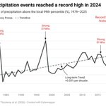
A new study confirms the record-high frequency of heavy precipitation events globally in 2024. scim.ag/3VQ5L92
1
8
1
24
2,724
Chad Thackeray retweeted
Gusty #SantaAnaWinds will be common region-wide tomorrow through Saturday. Some areas that don't typically see gusty Santa Ana Winds, such as the Los Angeles Basin, may see breezy east winds Friday and Saturday. Plan for power outages and travel delays. #CAwx
4
56
6
148
13,244
The strongest and most widespread offshore wind event in some time will occur in California, creating hazardous fire weather through the rest of the week. Conditions will be the worst Thursday and Friday. Winds should be the strongest in the typical Santa Ana wind corridors in SoCal, with widespread gusts of 35-55 mph and as high as 50-70 mph in the most wind-prone places. In NorCal, winds could gust to 40 mph in exposed spots like the North Bay and the west slope Northern Sierra. Temperatures will be above average, and humidity will be very low everywhere. Recent rains have absolutely had some positive impact on fuel moisture, but it won't be enough in many places to cancel out fire risk. Some areas didn't even get anything from our recent storms. Even then, there are past examples of devastating wildfires occurring following substantial rainfall, so everyone needs to stay vigilant. Public safety power shutoffs are expected in large swaths of both NorCal and SoCal, so make sure you visit PG&E and SCE's websites so you can plan accordingly. Take the necessary precautions so you can quickly evacuate in the event of a wildfire. Stay safe! #CAwx
18
94
17
410
40,235
The intensifying El Niño is likely to bring above-average temperatures to much of the globe and shift rainfall patterns, increasing the risk of drought and floods in different regions. Read the latest WMO Global Seasonal Climate Update: bit.ly/4hFr1XD
4
145
22
288
29,549
Chad Thackeray retweeted
Strong winds are coming Thursday through Saturday for portions of Los Angeles, Ventura, Santa Barbara, and San Luis Obispo Counties. Thursday Night through Friday is the most concerning. Here are some expected impacts and actions you can take to be ready. #cawx
4
72
5
159
15,582
Rachel and its moisture will spread over portions of the Southwest United States and northern Baja California peninsula through this weekend. This will lead to increasing coverage of rainfall and for the potential for significant flash and urban flooding.
21
126
34
892
88,958
El Niño continues to strengthen, with a strong-to-very strong El Niño likely through January-March 2027 (remaining greater than an 83% chance). An #ElNino Advisory remains in effect. #ENSO cpc.ncep.noaa.gov/products/a…
5
144
12
407
32,442
Chad Thackeray retweeted
Daily record high temperatures for today have been broken or tied across 8 locations today, and tying or breaking high temperature records at a few locations will still be possible through Thursday. #CAWx #CAHeat
9
41
5
129
13,330
Chad Thackeray retweeted
The brand new ECMWF El Niño forecast has just arrived, and it's quite something. It shows the El Niño peaking around or just above 4°C in December. But what's most notable is the duration of record-breaking conditions, with with many members remaining above 3°C into April!
22
199
26
738
77,532
Chad Thackeray retweeted
As we all know it's been a very hot summer. To put this summer into context, 2026 ranks as the hottest summer of all time (June 1-Oct 4 in Downtown LA). Here is a graphic to illustrate. #LAHeat #LAwx
31
155
29
717
74,793
Chad Thackeray retweeted
Downtown LA is now at 102, which breaks the daily record! 🥵
3
15
5
60
5,066
Chad Thackeray retweeted
11 AM HST Wed Sep 23 (Advisory 13) Key Messages for Tropical Storm #Nolo. Latest info: hurricanes.gov
1
41
1
85
18,108
Chad Thackeray retweeted
It was a record breaking day...
8
72
3
278
20,828