

*Not Meteorologists, however years of extreme weather chasing experience UK & abroad. From Kent, UK.
Kent, UK
Joined July 2012
- Tweets3.2K
- Following531
- Followers3K
- Likes4.4K


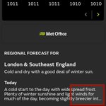


Very pronounced sun halo up here in London this morning ☀️😇
This is due to the light being reflected / refracted by ice crystals in the very high clouds.
Often a sign of deteriorating weather within the following 24 hours

KentStormChasers retweeted

20 years ago today Birmingham was struck by this T5/6 tornado. torro.org.uk/pdf/Birmingham_…

KentStormChasers retweeted

Good morning. Tens of thousands of lightning strikes were recorded yesterday as active thunderstorms swept through parts of England and Wales, with some of these producing large hail.
More storms will be possible today across the far south of England, Wales and even south-west Ireland.

KentStormChasers retweeted

New ESSL study: Lightning kills about 64 people per year across Europe, 78% of them being men. In Eastern Europe, most victims were at work, whilst in Western Europe people were typically engaged in leisure activities. Read more here: doi.org/10.1175/WCAS-D-24-00…


Open letter to the @metoffice requesting information on the feasibility of releasing advanced doppler radar products to researchers and weather enthusiasts here in the UK.
Please show your support by liking / commenting to see how many people would be interested! 🌪️

KentStormChasers retweeted
Yesterday was quite an active day for NW Europe with over 20,000 lightning strikes detected. Not bad for December!
It will remain quiet for the next week or so as high pressure takes over, so I wouldn't expect any more convective activity until the new year.

KentStormChasers retweeted

🌍🚀 New MTG Satellite Imagery from @Eumetsat Now on Ventusky in High Resolution! 😍 Experience stunning, natural-looking visuals created by combining visible and infrared spectral bands. 🌈 These images offer unmatched clarity for tracking real-time weather events. Learn more in the article: my.ventusky.com/guide/news/h…

KentStormChasers retweeted

More footage of a circulation near Luton today ... xitter.cf/Met4CastUK/status/1837…


KentStormChasers retweeted
Has anyone been wondering why there's been a decline in #thunderstorms in recent summers in your part of the UK? In my latest blog for @Netweather I look at the decline in thunder days & explain a possible reason: i.e. warming arctic could be behind it
netweather.tv/weather-foreca… – at Whyteleafe, South East

KentStormChasers retweeted
THIS WEEK ...
No sign of any summer warmth.
Our anomaly charts shows how temperatures compare to normal for early June.
🟥Warmer than normal
⬜️Temperature around average
🟦Cooler than normal


RT @Ventuskycom: The chance of seeing the aurora borealis has started to increase again in the past few hours, but it is not reaching the…
KentStormChasers retweeted

A thundery plume is possible later on Wednesday into Thursday this week. Main risk currently further East across East Anglia, South East England & the East Midlands. Details will be resolved in the coming days. More information at: ukcwp.com/general-weather-ne…

KentStormChasers retweeted
Wet, windy & cool tomorrow with an initial cold front which could form a squall line although AROME does seem to be overzealous with them most of the time so I would expect something a bit more broken up! Showers following in after could have rumbles of thunder & hail with them.