



mera retweeted

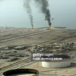
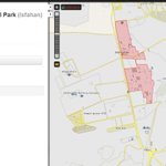
Explosions seen from Al Jahra Stables (اسطبلات الجهراء) towards Ali Al Salem Airbase.
Pov C: 29.322155, 47.578158
h/t @MeraMeraska @john_marquee
@GeoConfirmed @FaytuksNetwork

mera retweeted
GeoConfirmed Iran.
Smoke is rising from an airstrike in the direction of an underground military complex in Khomein, southwest of Tehran.
Point of view - 33.63796, 50.089849
J3QQ+5WQ Khomeyn, Markazi Province, Iran
Location of underground military facility: 33.561729, 50.131174 (See our map)
GeoLocated by @WillUnderhill23 and @MeraMeraska
Geolocation:
xitter.cf/WillUnderhill23/status…
Geo of the base: xitter.cf/MeraMeraska/status/202…
Location:
geoconfirmed.org/iran/28231a…
Sources:
xitter.cf/DrEliDavid/status/2027…
t.me/kianmeli1/80872
Visit our map: geoconfirmed.org/iran

mera retweeted

Iran 🇮🇷 28/02/2026
Smoke rising from an airstrike likely on a tunnel military complex in Khomein, southwest of Theran.
33.637960, 50.089849
@GeoConfirmed

mera retweeted
Per these two geolocations, we can triangulate that this area is most likely what caught fire this evening. Appears to be a depot/ junkyard within the military complex.
h/t @MeraMeraska and @FaytuksNetwork community
xitter.cf/andynovy/status/201986…
xitter.cf/andynovy/status/201986…
@GeoConfirmed


mera retweeted
GeoConfirmed Announcement.
For the OSINT community:
GeoConfirmed QGIS Plugin is now available.
Query GeoConfirmed's conflict geolocations directly from QGIS with:
• Boolean keyword search
• Faction & date filtering
• Spatial filters (radius, canvas extent, within polygon)
github.com/Silverfish94/GeoC…
Please provide feedback in PM if you have feedback.

mera retweeted

Geolocation: Hamas appears to stage hostage remains discovery: body bag buried then "uncovered" by excavator for Red Cross witnesses. Shuja'iyya, Gaza.
Location: 31.5057910, 34.4766970
@GeoConfirmed


An Israeli military drone video shows Hamas staging the recovery of the remains of a hostage it returned to Israel last night.
The remains were identified as belonging to Ofir Tzarfati, whose body was recovered by the IDF in the Gaza Strip in December 2023, less than two months after his abduction during the Hamas onslaught.
The video shows Hamas operatives bringing a body bag from a building to a hole that was dug in the ground, before covering it in dirt. The operatives are then seen digging up the body bag they had just hid with an excavator, before dumping it nearby.
Red Cross representatives are seen arriving, as the excavator dumps more dirt on the body bag. The Hamas operatives then dig up the body bag in front of them, with one seen taking pictures with his phone.
mera retweeted
GeoConfirmed Investigation - October 7th 2023 - Publication of the map.
geoconfirmed.org/7oct
Also named Operation Al-Aqsa Flood - Black Sabbath - Simchat Torah Massacre - the 7 October attacks.
In the early morning of October 7th, different factions, likely coordinated by The Palestinian Joint Operations Room, launched a major attack launched on Israeli territory. It is considered one of the deadliest days in Israeli history, with a total of 1,195 people killed according to official figures, including 815 Israeli civilians (including 36 children), 71 foreign nationals, and 379 members of Israeli security forces. In addition, 251 hostages were taken, many still in captivity, creating the worst hostage crisis in Israeli history.
(Sources: france24.com/en/live-news/20…
csis.org/analysis/hamass-oct…
en.wikipedia.org/wiki/Octobe…)
The GeoConfirmed volunteer team has undertaken the ambitious task of investigating and documenting the events of that day.
For over 2 years, our volunteers have collected and analyzed publicly available footage, establishing their locations and a timeline of the events. Despite experience monitoring multiple conflicts, the footage from that day is among the most disturbing that they have ever encountered. However, due to the proliferation of misinformation about these events, we believe it is important to organize the footage in one place and index it in space and time so that anyone with doubts can see what happened with their own eyes.
Though we have chosen to publish our map, there are still hundreds of additional frames awaiting analysis. But, given the gravity of the events on that day, we have decided to move forward with publication of our map, rather than waiting for the analysis of the additional frames, which could take several more months. The time of our volunteers is a finite resource, and we continue to monitor global conflicts, including the wars in Ukraine, Myanmar, Gaza, Sahel region and more. Our hope is that publication now will encourage others to share open-source efforts at documenting the October 7th attack.
Terminology
For this investigation, the following terminology is used:
Militants: Individuals assessed to be Palestinian, carrying weapons or identified by other markings like headbands.
We use this as a category for all militant groups involved in the attack. Other options were fighters, insurgents, terrorists, or unlawful combatants, but because the appropriate use of such designations depends on many factors, some hard to measure, we decided to use the term “militants.”
Israeli Security Personnel: Individuals identified by their uniforms and gear, including military (IDF), police, and other armed security.
Palestinian/Israeli Civilians: Individuals dressed in civilian clothing, without any visible weapon.
Methodology
A significant portion of the footage in this investigation comes from GoPro cameras worn by militants involved in the attack, most collected after they were killed by Israeli security personnel. Other footage was recorded by first responders, security forces, and civilians using cell phones, dash cams, and surveillance cameras. Almost all of it is collected from social media networks such as X/Twitter and Telegram.
Geolocations are determined using well-established methods, comparing features visible in the footage with satellite and panorama imagery that is publicly available from tools like Google Earth and Google Street View. Each geolocation is accompanied by a proof, an annotated diagram used to explain the geolocation analysis, typically as X/Twitter posts published by our volunteers. Readers can thus verify for themselves the geolocations published on our map.
The timeline of events is based on comparison of the footage, sun angle, and other contextual clues. While locations can be determined precisely, timing is an informed assessment.
Militant Groups
(Picture source: longwarjournal.org/archives/……)
There are different Palestinian militant factions under an umbrella group known as The Palestinian Joint Operations Room, and some of those factions are designated as terrorist organizations by the US, EU and other nations.
eur-lex.europa.eu/legal-cont…
Militant groups can at times be recognized by the well-known color and style of headbands that they wear. At other times, a group’s participation can be inferred when they publish footage and claim responsibility on their official social media channels.
For our October 7 map, we have chosen to align the pin colors with the corresponding militant groups involved. For example, if you want to view all geolocated footage involving hostages, you should select the hostage icon from each faction (represented by different colors) to display all related incidents on the map.
Identified participation of militant groups based on the visual headbands in footage regarding Oct 7th 2023:
(Some of those also identified by @BBC Verify: bbc.com/news/world-middle-ea…)
Green: Hamas, Izz ad-Din al-Qassam Brigades
Map colour: Dark Green
Black: Palestinian Islamic Jihad (PIJ), Al-Quds Brigades
Map colour: Black
Black: Palestinian Mujahideen Movement, Mujahideen Brigades
Map colour: Grey
White: Palestinian Freedom Movement, Al-Ansar Brigades
Map Colour: White
Red: Popular Front for the Liberation of Palestine (PLFP), Abu Ali Mustafa Brigades
Map Colour: Red
Red: Democratic Front for the Liberation of Palestine, National Resistance brigades, also known as Martyr Omar Al-Qassem Forces or Martyr Omar Al-Qasim Forces.
Map Colour: Pink
Yellow: al-Aqsa Martyrs' Brigades
Map Colour: Yellow
Other used colours:
Dark Blue: Israeli Security Personnel
Light Blue: Israeli Civilians
Brown: Palestinian civilians
Light Green: Palestinian Militants of unknown affiliation
Purple: Unknown affiliation (Could be Israeli or Palestinian)
(Picture source: en.milligazete.com.tr/press_……)
Based on all the footage we have seen, some of our insights about this attack:
On October 7, 2023, Hamas launched a coordinated and unprecedented attack on Israel. The assault began around 6:30 a.m., at sunrise, with a massive barrage of rockets fired from Gaza into southern and central Israel, overwhelming defense systems.
As rockets rained down and all non-essential Israeli personnel and civilians took shelter, the first wave of militants from various factions began their assault on the heavily fortified border.
To initiate the attack, they deployed bomber drones to disable the remote-controlled machine guns positioned on the watchtowers. Using explosives and bulldozers, they breached the border fences and walls, creating multiple entry points.
Some militants infiltrated Israel by sea near Zikim, while others used motorized paragliders to cross into Israeli territory, tactics that had been rehearsed in joint drills prior to the attack.
After the border defenses were breached, the militants advanced toward IDF bases, where they killed and captured Israeli soldiers. Due to the lack of defenses and the rapid pace of the operation, the militants soon began raiding nearby kibbutzim. They showed no mercy to anyone they encountered, resulting in the deaths of hundreds of civilians—sometimes in extremely brutal ways, including throat-cutting. Cars and houses were set on fire.
During the attack, homes were set on fire, and widespread looting took place, with Palestinian militans and civilians stealing property, equipment, and even animals from the affected communities. The sheer number of attackers, including both militants and civilians, overwhelmed local defenders and contributed to the scale of violence and abductions.
Based on available footage, the first wave consisted of well-equipped militants wearing military gear and carrying weapons, from RPGs to sniper rifles.
They used trucks, including technicals, and motorcycles to move quickly.
This initial group was followed by a second wave: armed Palestinian civilians: dressed in civilian clothing but carrying weapons. Before noon a third wave arrived: Palestinian civilians, numbering in the hundreds or possibly thousands, who crossed the border to loot Israeli kibbutzim.
Footage also showed not only militants but also Palestinian civilians taking hostages during the chaos. As hostages were transported back to Gaza, the hostage-takers were cheered by Palestinian civilians, some of whom spat on or beat the captives as they passed. Armed militants also brought some hostages to Palestinian hospitals.
It took the IDF several hours to, and in some areas multiple days, to fully clear the region of militants, as they confronted the aftermath of one of the largest terrorist attacks in Israel’s history.
We want to caution you that some of the footage from October 7, 2023, shared in this thread may be very graphic, as we have selected videos to highlight the intensity and harshness of the events on that day.
Credits
This is a @GeoConfirmed Investigation conducted by @TwistyCB, @GeoRaccoon, @davidnewschool, @COUPSURE and @MiddleEastBuka, @adler_zvi and @KJ_X23 with the support of @PowerPigeon2.
We want to thank all the other geolocators and the full geolocation community, without their geolocations and support this investigation wouldn't have the same value as it has now.
In the following days/weeks/months we will keep updating this map when new geolocated footage emerges.
If you like our work you can buy us a coffee.
buymeacoffee.com/geoconfirme…
This helps:
Improving our maps and user interface.
Improving data management.
Buying Sat Img for confirmations and investigations.
More information about our work:
World: geoconfirmed.org/world (500+)
Ukraine: geoconfirmed.org/ukraine (49000+)
Sahel: geoconfirmed.org/sahel (830+)
Syria: geoconfirmed.org/syria (1050+)
Israel: geoconfirmed.org/israel (6400+)
Iran: geoconfirmed.org/iran (300+)
Yemen: geoconfirmed.org/yemen (200+)
Myanmar: geoconfirmed.org/myanmar (780+)
Cartel Map: geoconfirmed.org/cartel (500+)
Thanks to all our volunteers all over the world!
1/x


mera retweeted
After Joshua Molle, a 21 year old student from Tanzania, was stabbed to death by militants of the Al-Aqsa Martyrs' Brigade, visible in other footage, they stamp on his body, and start shooting at his head. Civilian Looters are just walking by.
31.4702, 34.49443
FFCV+3QM Nahal Oz, Israel
GeoLocated by @TwistyCB
Geolocation:
xitter.cf/TwistyCB/status/…
Location:
geoconfirmed.org/7oct/bba48e…
Sources:
t.me/southfirstresponders/47…
xitter.cf/TwistyCB/status/…
Visit our map: geoconfirmed.org/7oct
10/x

mera retweeted

The reason for the secondary explosion in Tel Nof, is that the factory containing explosives located in this location was hit.
The impact was massive and caused damage to surrounding buildings, with a fairly deep fissure forming at the impact's epicenter.
31.83070°, 34.82166°

mera retweeted

The largest aid flotilla in history has been attacked twice in two days whilst in port in Tunisia. Open source analysis suggests an incendiary munition is to blame, contradicting official statements. bellingcat.com/news/2025/09/…

mera retweeted

I was pleased to contribute to this clear write-up from my former @Arms_Research colleague, Trevor Ball (@Easybakeovensz):
bellingcat.com/news/2025/09/…
My full comments are appended below.
mera retweeted

Update!
These past few weeks I’ve been setting up my next venture: Working independently as an OSINT analyst and media literacy lecturer.
If you or your organization are looking for support in OSINT, media literacy, or verification, I’d be happy to connect: [email protected]

mera retweeted

Decided to try my hand at a go fund me, this money will be primarily used to purchase higher resolution satellite imagery within the Gaza strip.
gofundme.com/f/aid-stinkys-o…
mera retweeted

We at the Institute found new activity at one of the Esfahan tunnel entrances that occurred during the last few days.
The northernmost tunnel entrance shows vehicles present and that access to the tunnel portal, which was previously blocked by backfilled dirt, has been gained within the last week.
The middle tunnel entrance shows activity in mid-July, including heavy machinery present, but no significant progress appears to have been made towards establishing tunnel portal access as of the end of July. The roadblocks on the road to the southernmost tunnel entrance remain; no activity is visible there.
Also at the main Esfahan site, minimal activity is visible around the destroyed buildings at the aboveground sites. Some roads have been cleared of debris but there is minimal vehicle presence. Several of the roads around the facilities remain uncleared from debris, with roadblocks installed.
At Fordow, the latest imagery of Fordow shows a new road being constructed towards the top of the lower hills on the east side of the Fordow site, away from the mountain containing the enrichment plant, but still within the outer security perimeters.
The earthworks in the area of the two ventilation shafts appear to have ceased. There is also no observable activity at the primary tunnel entrances leading into the enrichment facility.

mera retweeted
Reportedly a Druze civilian being executed in central Suwayda next to governate building.
C: 32.710131°N 36.569829°E
S:xitter.cf/BrotherRasheed/status/…
@GeoConfirmed @FaytuksNetwork


mera retweeted

[Geolocation]
Three Druze men are forced to jump from a balcony at gunpoint and are shot at as they leap to their deaths in the city of Suwaida, Syria.
32.7125632, 36.5649529
@Shayan86
@andynovy
@GeoConfirmed Syria


mera retweeted
Men found hung upside down in Al Jnenih.
Judging by the shadows this is from today around 16:00.
C: 32.899104°N 36.729869°E
S: xitter.cf/Philipp27960841/status…
@GeoConfirmed @FaytuksNetwork


