

I record weather data. Sometimes photos/timelapses of what the weather is doing in my area and occasional forecasts when I've got time.
Bridgwater, Somerset
Joined June 2019
- Tweets8K
- Following216
- Followers1.1K
- Likes9.4K






Pinned Tweet
youtu.be/dz17Bpa7O5Q?si=OvBM…
Check out my first video on my new YouTube channel where I can post these videos in 4K.
Currently in the downstream of the Bristol Channel where the winds funnel down. Pws reports winds to 70mph. Fences down, Debris everywhere, over turned vehicles on the m5 in crosswinds, multiple large trees down over major routes. very impactful for a yellow warning. #Austen

3
329
Robbie's Weather retweeted

22 Oct 2026
14 UTC
K1
The MSLP fell 21.8 hPa in the last 3 hours at K1 & the wind has now veered, as cold front sweeps through behind it.
According to the ECMWF central pressure was forecast at 976 hPa at 15 UTC, so the 972.6 hPa is deeper than forecast.
#ukweather #K1 #Austen

Robbie's Weather retweeted

This mornings sunrise from the Scottish Highlands was just out of this world, valley fog combined with a red sky and even a little monochrome rainbow, I couldn't contain my excitement
@StormHour @ThePhotoHour #loveukweather – at Doune, Scotland


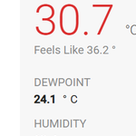
Dew points almost reaching 25c here with close proximity to the Bristol Channel, Absolutely stifling/unbearable

2
205
Ukv got this absolutely bang on, 10/10 forecast. Beat ever model by a marathon. What a supercell this is!

UKV continues to forecast a supercell tracking through southern england creating its own environment and circulation. If this is true or not we have to wait and see. Excessively large hail and damaging wind gusts would come out of this with a small tornado risk on any hook echo.

1
21
2,638


UKV continues to forecast a supercell tracking through southern england creating its own environment and circulation. If this is true or not we have to wait and see. Excessively large hail and damaging wind gusts would come out of this with a small tornado risk on any hook echo.
The heat early next week will feel very oppressive, high humidity and temperatures around 30c or so will make it feel warmer than the thermometer says especially in the South of England. Very uncomfortable!


Model conflicts appearing again as critical processes of this low evolution being slingshot around another area of low pressure causing model confusion and a higher degree of model uncertainty regards to snow weds night. We should get a better idea tomorrow morning (on the day)


12
1,499
Robbie's Weather retweeted

Main Uncertainties
1) How far north will the band of snow reach - linked to the depression itself and its depth.
2) How Heavy will the rain be across Southern counties already impacted so much recently - strongly suggest another 30-50mm perhaps over 60mm across even modest hills
3) note - the Wind will be ESE again so Eastern facing slopes in SE Wales and SE Devon look prone - Otter Valley again looks prone to risk of flooding-
4) How much snow - Models suggest up to 20-30cm over the Brecons and Black Mountains
5) How much snow over the other areas of Central and Southern England, models much more variable here and this aspect of the forecast will need considerable fine tuning tomorrow.
An increasingly interesting day and night ahead on Wednesday. If you do live in the South of England please be aware of this, and M4 north keep this in mind
Obviously as we have seen before ,when rain turns to snow quickly after its rained, the salt washes off and the roads, motorways and major "A" - Trunk Arterial roads can become gridlocked and locked with traffic.
More to come.
Paul


