

🗺️Mapping 1️⃣2️⃣~ x Native Languages of British Isles 🇬🇧(🏴🏴🏴NI〓〓)🇮🇪🇮🇲🇯🇪🇬🇬
🇬🇧🇮🇪🇮🇲🇯🇪🇬🇬
Joined April 2016
- Tweets3.4K
- Following5.8K
- Followers4.9K
- Likes10K

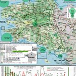


2024 Breton Language / Speakers Map
teapawt.net/UKLanguageMaps/status/…

ℹ️1/11🧵⬇️
#Breizh|#Bretagne 𝍎𝌆🇫🇷
📍maps.app.goo.gl/uTuhf4yrZUXs…
🟩#Brezhoneg|#Breton Map 🗺
131k Speakers🗣|*237k Ability
6%|*13% W #Brittany
🔻1950, 1.1m|75%🗣
🔁#Celtic;#Cymraeg+#Kernewek
ℹ️@OPAB_OPLB+fr.brezhoneg.bzh/
🌐en.wikipedia.org/wiki/Breton…
🎥youtu.be/cUtxMV7O00A?si=tUN3…

Breton Language Map 2024
teapawt.net/UKLanguageMaps/status/…
ℹ️1/11🧵⬇️
#Breizh|#Bretagne 𝍎𝌆🇫🇷
📍maps.app.goo.gl/uTuhf4yrZUXs…
🟩#Brezhoneg|#Breton Map 🗺
131k Speakers🗣|*237k Ability
6%|*13% W #Brittany
🔻1950, 1.1m|75%🗣
🔁#Celtic;#Cymraeg+#Kernewek
ℹ️@OPAB_OPLB+fr.brezhoneg.bzh/
🌐en.wikipedia.org/wiki/Breton…
🎥youtu.be/cUtxMV7O00A?si=tUN3…
British Isles Linguistic Maps retweeted

Call for action after fall in number of children speaking Welsh bbc.in/3W0Dm0k

British Isles Linguistic Maps retweeted

What language is the official language in the most countries?
Data for the most speakers: brilliantmaps.com/most-spoke…

ℹ️1/11🧵⬇️
#Breizh|#Bretagne 𝍎𝌆🇫🇷
📍maps.app.goo.gl/uTuhf4yrZUXs…
🟩#Brezhoneg|#Breton Map 🗺
131k Speakers🗣|*237k Ability
6%|*13% W #Brittany
🔻1950, 1.1m|75%🗣
🔁#Celtic;#Cymraeg+#Kernewek
ℹ️@OPAB_OPLB+fr.brezhoneg.bzh/
🌐en.wikipedia.org/wiki/Breton…
🎥youtu.be/cUtxMV7O00A?si=tUN3…
ℹ️1/11🧵⬇️
#Breizh|#Bretagne 𝍎𝌆🇫🇷
📍maps.app.goo.gl/uTuhf4yrZUXs…
🟩#Brezhoneg|#Breton Map 🗺
131k Speakers🗣|*237k Ability
6%|*13% W #Brittany
🔻1950, 1.1m|75%🗣
🔁#Celtic;#Cymraeg+#Kernewek
ℹ️@OPAB_OPLB+fr.brezhoneg.bzh/
🌐en.wikipedia.org/wiki/Breton…
🎥youtu.be/cUtxMV7O00A?si=tUN3…
British Isles Linguistic Maps retweeted

Alongside 'ginnel', 'snicket' is also used across Yorkshire to refer to alleyways, while 'cut' is a common term in the North East, 'jitty' can be found in the East Midlands, and 'entry' is used on Merseyside and parts of the West Midlands
yougov.com/en-gb/articles/55…

British Isles Linguistic Maps retweeted
What do you call an alleyway? Across Britain, there are more than a dozen dialect words for a narrow passageway, with 'ginnel', 'cut' and 'snicket' among the most common
Alley: 84%
Passage: 31%
Ginnel: 14%
Cut: 7%
Snicket: 6%
Entry: 6%
Close: 6%
Gully: 4%
Jitty: 4%
Wynd: 2%
Vennel: 2%
Twitten: 1%
Tenfoot/eightfoot: 1%
Pend: 1%

British Isles Linguistic Maps retweeted

Belfast to get first Ulster Scots street sign since rule change. bbc.in/3VFRN9I

ℹ️1/11🧵⬇️
#Breizh|#Bretagne 𝍎𝌆🇫🇷
📍maps.app.goo.gl/uTuhf4yrZUXs…
🟩#Brezhoneg|#Breton Map 🗺
131k Speakers🗣|*237k Ability
6%|*13% W #Brittany
🔻1950, 1.1m|75%🗣
🔁#Celtic;#Cymraeg+#Kernewek
ℹ️@OPAB_OPLB+fr.brezhoneg.bzh/
🌐en.wikipedia.org/wiki/Breton…
🎥youtu.be/cUtxMV7O00A?si=tUN3…
🧵9/11
Likely many will recognise Breton song 🎼
Gortoz a Ran (I'm waiting)
[Black Hawk Down 🚁 (2001) 🎼]
by Denez Prigent & Lisa Gerrard
Sang in Celtic #Breton|#Brezhoneg language which has 131,000 speakers in #Brittany 🇫🇷
🎵open.spotify.com/track/00sug…
🎥youtu.be/5nl1WK-uKxw?si=CBZ7…
British Isles Linguistic Maps retweeted

Lake Michigan’s largest island was once the centre of a self-declared Mormon kingdom.
Then the “king” was shot, his followers were driven off, and the island became mostly Irish, with Catholic services still being held in Irish Gaelic decades later.
This is Beaver Island.
1/n

British Isles Linguistic Maps retweeted
🧵⬇️
🟦#Gàidhlig|#Gaelic Ability Map🗺
130k🗣📖✍️💭
•57% Outer #Hebrides;
72%#Scalpay
70%+#Eriskay/#SouthUist
66%#Barra
63%#Benbecula/#NorthUist
60%#Harris
51%#Stornoway
•29% Inner #Hebrides;
44%#Tiree
36%#Skye
25%#Islay
18%#Mull
•16% NW #Highlands
🔗scotlandscensus.gov.uk/atlas…


1️⃣8️⃣9️⃣1️⃣ #Scotland|#Alba 🏴
Language Map🗺⬇️
🔵#Gaelic/#Gàidhlig Speakers 🗣
📍#Highlands & #Hebrides
254k 🗣; 44k Mono/211k Bi
🔴#Scots & #English [4m🗣] [@scotslanguage]
🗣@SpeakGaelic
📺@bbcalba
📻@BBCRnG
🎓@SabhalMorOstaig
🔗behance.net/gallery/11091124…

British Isles Linguistic Maps retweeted
ℹ️1/11🧵⬇️
#Breizh|#Bretagne 𝍎𝌆🇫🇷
📍maps.app.goo.gl/uTuhf4yrZUXs…
🟩#Brezhoneg|#Breton Map 🗺
131k Speakers🗣|*237k Ability
6%|*13% W #Brittany
🔻1950, 1.1m|75%🗣
🔁#Celtic;#Cymraeg+#Kernewek
ℹ️@OPAB_OPLB+fr.brezhoneg.bzh/
🌐en.wikipedia.org/wiki/Breton…
🎥youtu.be/cUtxMV7O00A?si=tUN3… – at Carhaix-Plouguer, France

British Isles Linguistic Maps retweeted

How does ability to speak Welsh look when measured by geographic county?
Our latest graphic uses Census 2021 data, aggregated to the 13 geographic counties - with Merionethshire / Meirionnydd the highest at 56.9%.
More Census data by geographic county at RealCounties.com.

ALT Census 2021 - number of people who can speak Welsh by geographic county - from RealCounties.com
British Isles Linguistic Maps retweeted

🇬🇮 Gibraltar National Day
Map ⬇️ created by my brother H/T @UKLanguageMaps
The spirit of the image is to highlight the vital military value 🇬🇮 provides 🇬🇧 and the vast historical ties that bind us.
A wealth of information is included, covering military, census information, previous borders etc.
🇬🇮🤝🏻🇬🇧
*C.2025, so some information dated such as HMS Trent currently.
@dparody @key2med @Gibdan1 @86SirRoge @BritishOverseas

ℹ️1/11🧵⬇️
#Breizh|#Bretagne 𝍎𝌆🇫🇷
📍maps.app.goo.gl/uTuhf4yrZUXs…
🟩#Brezhoneg|#Breton Map 🗺
131k Speakers🗣|*237k Ability
6%|*13% W #Brittany
🔻1950, 1.1m|75%🗣
🔁#Celtic;#Cymraeg+#Kernewek
ℹ️@OPAB_OPLB+fr.brezhoneg.bzh/
🌐en.wikipedia.org/wiki/Breton…
🎥youtu.be/cUtxMV7O00A?si=tUN3…
ℹ️1/11🧵⬇️
#Breizh|#Bretagne 𝍎𝌆🇫🇷
📍maps.app.goo.gl/uTuhf4yrZUXs…
🟩#Brezhoneg|#Breton Map 🗺
131k Speakers🗣|*237k Ability
6%|*13% W #Brittany
🔻1950, 1.1m|75%🗣
🔁#Celtic;#Cymraeg+#Kernewek
ℹ️@OPAB_OPLB+fr.brezhoneg.bzh/
🌐en.wikipedia.org/wiki/Breton…
🎥youtu.be/cUtxMV7O00A?si=tUN3…
ℹ️1/11🧵⬇️
#Breizh|#Bretagne 𝍎𝌆🇫🇷
📍maps.app.goo.gl/uTuhf4yrZUXs…
🟩#Brezhoneg|#Breton Map 🗺
131k Speakers🗣|*237k Ability
6%|*13% W #Brittany
🔻1950, 1.1m|75%🗣
🔁#Celtic;#Cymraeg+#Kernewek
ℹ️@OPAB_OPLB+fr.brezhoneg.bzh/
🌐en.wikipedia.org/wiki/Breton…
🎥youtu.be/cUtxMV7O00A?si=tUN3…