

Making a new kind of map. Modern, minimal, and stunningly detailed.
Burlington, Vermont
Joined February 2020
- Tweets53
- Following0
- Followers679
- Likes46


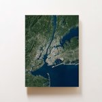


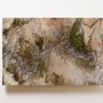

🎁 "This is probably the most well received gift I have ever purchased for my partner. He was blown away by the style, substance, and sophistication of this beautiful work of art."
Get your Ramble before our holiday order deadline of 12/9.
ramblemaps.com/

1
Ramble Maps retweeted

Psyched to release this print of Mount Rainier/Tahoma today on @ramblemaps
It is the culmination of everything we've learned these last couple of years making these images. Combining NAIP orthoimagery + LiDAR elevation data.
ramblemaps.com/mount-rainier…


Ramble Maps retweeted
Maui for @ramblemaps
Used 4 different satellite passes for this one to get a cloud-free view.

Google Earth is awesome. The window that it provides into our world is mind-blowing and the imagery is fantastic.
At Ramble, we make wall art that is like if Google Earth were designed for your wall.
ramblemaps.com/if-google-ear…

New on the site: Puerto Rico
ramblemaps.com/puerto-rico-m…
Part of our Natural Color series of maps that blends satellite imagery with elevation models.

1
Ramble Maps retweeted
New post: If Google Earth Were Designed For Your Wall
(includes lots of pretty pictures of earth)
ramblemaps.com/if-google-ear…

Ramble Maps retweeted
Turning satellite imagery into wall art.
The Big Island of Hawaii for @ramblemaps
How we make the world's most detailed (print) maps.
ramblemaps.com/worlds-most-d…

5

Death Valley National Park.
Gonna have to put it on the list!
#mapart #sentinel2 #satellite #wallmap #nationalparks


Anyone know any Park Rangers?
We’d like to donate maps to national park visitor’s centers and would love to be connected to the right people! #nationalparks #nps
Ramble Maps retweeted
Mount St. Helens erupted 41 years ago today.
Here it is in high resolution LiDAR.

Flat states can be beautiful too!
See all our states, flat and mountainous alike: ramblemaps.com/states
#terrain #wallart #wallmap #cartography #maps


2
Our face-mounted acrylic maps are modern, minimal, and stunningly detailed.
ramblemaps.com
Ramble Maps retweeted

From our Winter Preview: Using lidar data, @ramblemaps are nine times more detailed than a typical USGS survey map — and they look cooler on your wall. 7dvt.co/2K0CovV
