

Providing Short 🌞 to 🥶 Long Range Forecasts For 🇬🇧 🇮🇪 🇪🇺 + 🌎 Weather Stories 🌩 🌡 🌧 ❄ 🏜 Check out my DAILY videos on YouTube!
Ross-Shire, Scotland
Joined July 2009
- Tweets58.9K
- Following600
- Followers5.6K
- Likes13.6K





**SUNDAY LIVE** #GlobalWeatherReportLIVE🔴Ed 206: UK: Double Storms, FRANCE: Record Drought to Record Rain + MORE... youtube.com/live/Rrep_DyTwX0
LIKE & SUBSCRIBE!

#StormBeolo peaks gusts & some highlights.
Note: Recent gust of 80 mph at Inverbervie.

Appears #StormBoelo at it's peak could'nt have been any closer to tying the UK October record set during Storm Amy last year.
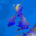
According to Meteociel, Stornoway measured 948mb late last night but curious if there are any sites lower? @danholley_ @RoostWeather @metoffice
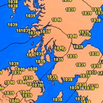
What a pressure difference from last Saturday to this Saturday...
From strongest October high in a decade for Scotland to extremely close to an October low pressure record in a week.


Morning all!
As #StormBoelo pulls away and pressure rises, we're seeing some big gusts (80+ Stornoway, 123 mph over Cairngorm) out of the NW.
Fair amount of damage with road and bridge closures.
Take care!


Appears #StormBoelo peaked around 948mb, exceptionally close to the UK's October record of 947.9mb set just last year.
Maybe somewhere set a new record?

**2nd SATURDAY VIDEO**#TropicalOutlook Typhoon Champi Once Cat 5 Slams Taiwan, E Pacific Activity FINALLY Easing Some? youtu.be/05JWbY0yPvg?is=JoMt…
LIKE & SUBSCRIBE!
#StormBoelo is fast approaching Lewis with central pressure currently 949mb.
Very heavy rain affecting many as pressure rapidly falls with frontal winds gusty and squally.
Core of strongest winds remain offshore.


#StormBoelo
I suspect October wind & pressure records will be threatened across the North next 24 hours...
**1st SATURDAY VIDEO** #StormAusten Departs #StormBeolo Arrives, Driven By Tropics & Even Causing Polar Vortex Disruption? youtube.com/watch?v=C6VhSKLc…
LIKE & SUBSCRIBE!


TROPICS TO POLE!
Notice an uptick in tropical activity in the IO lately?
#StormAusten and now #StormBoelo is part of a chain of events which can be traced back to the tropical Indian Ocean 10 or so days ago and all this looks to be even affecting the stratosphere above the pole


Think a piece of Josephine is actually part of system 3 (due Mon-Tue) not #Boelo . My mistake... U get the idea!

Once (part) of Subtropical Storm Josephine & riding/crossing a 200+ mph trans Atlantic jet stream, #StormBoelo could sweep into the NW Scotland tomorrow night with near record low pressure for Oct.
80-90mph winds in exposed W/NW, 100+ gusts over mtns, 65-75 widely!


MarkVoganWeather.com retweeted

Wow! Latest ECMWF 12z is going all out in the stratosphere, now forecasting an actual Stratospheric Warming event with a wind reversal, making it an official SSW event.
It will likely not remain at this, as this would be an unprecedented event, and the model trend map shows quite a spread between the last runs. But even seeing this suggested at this time is really insane.
All the maps are available in my Polar Vortex hub (link in the comments)
@judah47
I have seen you noticed the 12z ECM, but did you know it also has a proper reversal? 😁


Once (part) of Subtropical Storm Josephine & riding/crossing a 200+ mph trans Atlantic jet stream, #StormBoelo could sweep into the NW Scotland tomorrow night with near record low pressure for Oct.
80-90mph winds in exposed W/NW, 100+ gusts over mtns, 65-75 widely!
MarkVoganWeather.com retweeted

As Storm #Boelo tracks across N/NW Scotland on Sat night, its central pressure is likely to be 946-949 hPa.
The current UK Oct low MSLP record is 947.9 hPa (Storm Amy 2025). There's a chance we could beat this... just one week after near-record high MSLP
xitter.cf/danholley_/status/2111…


**FRIDAY VIDEO** Atlantic Storm Train Cranks Throwing 3 Bomb Cyclones Into Europe, Even Weakening Polar Vortex? youtube.com/watch?v=LYuOEOnw…
LIKE & SUBSCRIBE!
