



Tango retweeted

Milder Atlantic air will move north from the south early this week, bringing spells of rain to many southern areas. However, colder and sunnier conditions will return later in the week as winds switch around to a northerly direction
Tango retweeted

We’re 2nd in the #PL heading into the break. 😁

Tango retweeted
Coming back to this...
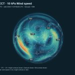
The sPV is currently record weak and despite model output being less enthusiastic, the flagged major SSW looks to begin sometime next week in a more significant weakening than last year's event.
Whether any E'rly anomalies 'drip down' is still uncertain.


Coming back to this...
The sPV is currently record weak and despite model output being less enthusiastic, the flagged major SSW looks to begin sometime next week in a more significant weakening than last year's event.
Whether any E'rly anomalies 'drip down' is still uncertain.
Tango retweeted

This nice plot from NASA's GSFC shows how unprecedentedly early was last November's large #PolarVortex (PV) disruption only to be eclipsed by a truly wide margin this year's large PV disruption & is in a league of its own. Who doesn't enjoy watching the re-writing of record books


Tango retweeted

I have a sneaking suspicion that the extreme eastward shift & intensity of this yr’s “Super” El Niño has something to do w/ the unprecedented, exceptionally early Sudden Stratospheric Warming Event that’s in most model forecasts
Plots via @Recretos’s site
severe-weather.eu/polar-vort…


Tango retweeted

With a lot of talk about the upcoming Polar Vortex disruption and a potentially official SSW (Stratospheric Warming) event, most people cant see what makes this event "unprecedented" as its often called. And for a good reason, as a single map of the #polarvortex can be vague in context. I decided to visualize that context.
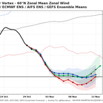
The official criteria for an SSW event is the reversal (0 or negative value) of the stratospheric winds at the 10mb level along the 60N polar circle line. We are still on the edge if we will reach a reversal with this event, but there are forecast runs that suggest its likely. Link to those live forecasts is in the comments 👇
Most of the SSW events occur in January and February. I decided to look at every first SSW of each season (some seasons had two) and when it occurred. As you can see, a reversal in the current event would break the record for the earliest SSW on date by at least 3 weeks!
This is really a strong outlier, and having an SSW this early in the season is what makes this event unprecedented in itself, perhaps more so than any temperature or pressure anomaly in the stratosphere.
Its likely not a coincidence we get this with a very strong Super El Niño ongoing in the Pacific. So overall, this is truly a very interesting season for anyone that is into monitoring the weather and seasonal development.

Tango retweeted

The best player in the world.
Our 2026 #BallonDor winner: HARRY KANE! 🏴🏆

ALT Harry Kane wins the Ballon D'or
Tango retweeted

LATE NOVEMBER / EARLY DECEMBER
First cold spell?
Recent modelling has been suggesting the potential for a very early (record breaking, in fact) major sudden stratospheric warming, this is when the usual westerly circulation above the Arctic reverses to easterly, whilst the likelihood of this remains uncertain, there are other key global drivers beginning to emerge.
During early November the MJO is now forecast to emerge into the east Indian Ocean and begin progressing eastwards through the Maritimes and into the Pacific as November progresses, this will trigger a renewed rise in AAM tendency (within an already very high AAM base state, thanks El Nino!), given the lag times involved with any potential SSW downwelling, the MJO triggered rising AAM and progressing into the Pacific, you could perhaps make a reasonable prediction that the later part of November / early December would increasingly be favourable to amplification of high pressure and high latitude blocking episodes. i.e, is this perhaps the first signal of an early cold spell beginning to materialise?
A few weeks ago you'd have been pretty bold to call anything other than a +NAO, Atlantic dominated pattern through November & December, the tide does appear to be changing on that idea.
Regardless of any SSW, the possibility of a coherent MJO cycle + rising AAM would have been shifting the thinking anyway, an early SSW probably wont hurt in helping that idea along..
SUMMARY:
The likelihood of blocking / colder outbreaks late November into early December appears to be growing some traction on the back of latest developments.
Whilst a milder, unsettled & stormier outlook had been anticipated for that period initially, new developments are starting to suggest other possibilities.