

Veteran/ Poet / Not a scientist
Hell
Joined January 2024
- Tweets21.3K
- Following300
- Followers7.4K
- Likes23.3K







Pinned Tweet
No Glory
Searching for adventure deep and wide
I found what the bravest men always tried to hide
There was never any glory down in the mud and trenches
Only our dreams dying with all our senses
Some fought hand to hand and tore each other apart
While the luckiest ones fell six feet from the start
So no matter the medals that end up on your chest
You can save your war stories I’m not impressed
If you ever feel like you missed your chance and lost.
Don’t forget you’ll never find the glory in battle worth the blood it costs.
DC
#poetry #poet #peace #warriorpoet
Yupppppp…..
Been saying it too! I almost feel stupid repeating myself over and over!
#CDIGR
THE R IS FOR REBALANCING!


DC retweeted

New ECMWF data shows the *strongest subtropical jet stream* in its forecast history blowing across the Pacific and U.S. this winter into next spring, with record-strength winds predicted from California to Florida.
There's even a connection to Europe.
El Niño fuels more thunderstorms near the equator, which release heat high into the atmosphere.
That extra warmth strengthens the Hadley circulation and steepens the temperature gradient between the tropics and the mid-latitudes, which strengthens the subtropical jet.
And that's why such a stormy winter is anticipated across the western, southern and eastern United States.


TSA posted the word “drone” repeatedly, but look what stands out: the capitalization changes throughout the post.
Some words appear as drone, while others appear as drOne.
What happens if we assign numerical values?
🔹 Lowercase o = 0
🔹 Uppercase O = 1
It turns into a binary-style pattern. The uppercase letters appear in clusters, creating a visual formation that expands and contracts.
Now look at another post from the same day.
Simon Says posted an actual eight-bit binary sequence.
When translated into ASCII, it reads:
“SIMON SAYS: PREPARE FOR WHAT’S TO COME.”
One account is emphasizing DRONES, while another is delivering a message about PREPARATION, both using text that invites numerical interpretation.
TSA has also been discussing expanded counter-drone capabilities and airspace security.
We’re being told to prepare.


DC retweeted
The latest ECMWF update has interestingly shifted its forecast El Niño peak (+4.1°C) one month later to January.
This likely owes to relentless westerly wind forcing that continues to shift warm water eastward across the Pacific.
El Niño's impacts will extend well into 2027.



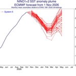
El Niño extraordinario 2026 está mostrando las temperaturas más altas del registro histórico que hayamos visto hasta ahora. Más de 30ºC en la región 3.4 del Pacífico Central y anomalías de más de 5ºC en la región del Niño 1-2. enosmonitor.c2.cl

DC retweeted

No importa si la metodología del cálculo de las anomalías de las temperaturas del mar sean hechas por los Australianos, los Europeos o los Americanos.
Al final del día lo que importa es la temperatura del mar.
En el centro del Pacífico esa temperatura (Región Niño 3.4) con la data de la #NOAA (oficial) es la mayor observada jamás. Por eso la @WMO y @NOAA estiman que este será el mayor evento #ElNiño observado.
Para los peruanos esto supone un sesgo a menores lluvias en nuestra sierra sur principalmente.
En el Pacífico Oriental (Región Niño 1+2), estamos para la época, igualmente más cálidos que nunca. Aun cuando por la estacionalidad no se ha alcanzado la mayor temperatura en esa región. Sin embargo, es muy probable - según los modelos, que tan bien pronosticaron este #ElNiño - que también termine siendo el más cálido desde que hay registros .
Para #Ecuador y #Perú esto supone lluvias costeras muy severas.
En noviembre, en apenas 3 días de lluvias, #Guayaquil y #Tumbes ya exhiben números elocuentes. Ambas ciudades están a pocos días de completar, desde el 1 de setiembre, lo que debe llover en 1 año.
En particular en #Guayaquil ya llovió el 20% de lo observado entre 1982-83 durante el Gran evento de aquellos años; mientras en #Tumbes, en estos 3 días de noviembre, ya precipitó la mitad de todo lo que llovió en octubre. Notable!


